
Airborne thermal infrared hyperspectral remote-sensing quantitative detection method for coal field fire zone

A technology of hyperspectral remote sensing and detection method, which is applied in the field of airborne thermal infrared hyperspectral remote sensing quantitative detection in coal field fire area, can solve the problem of inability to quickly and accurately locate the burning position and combustion range of coal fire, and reach the scope of coal fire area. Accurate, eliminate environmental radiation, and the effect of simple steps

Active Publication Date: 2018-05-11
BEIJING RES INST OF URANIUM GEOLOGY
View PDF4 Cites 11 Cited by
  • Summary
  • Abstract
  • Description
  • Claims
  • Application Information

AI Technical Summary

Problems solved by technology

[0005] The purpose of the present invention is to address the deficiencies of the prior art and to provide an airborne thermal infrared hyperspectral remote sensing quantification method for coalfield fire areas that solves the problem of being unable to quickly and accurately locate the coal fire combustion position and combustion range in a complex and dangerous environment in coalfield fire areas. detection method

Method used


Image

  • Airborne thermal infrared hyperspectral remote-sensing quantitative detection method for coal field fire zone
  • Airborne thermal infrared hyperspectral remote-sensing quantitative detection method for coal field fire zone
  • Airborne thermal infrared hyperspectral remote-sensing quantitative detection method for coal field fire zone

Examples


Embodiment

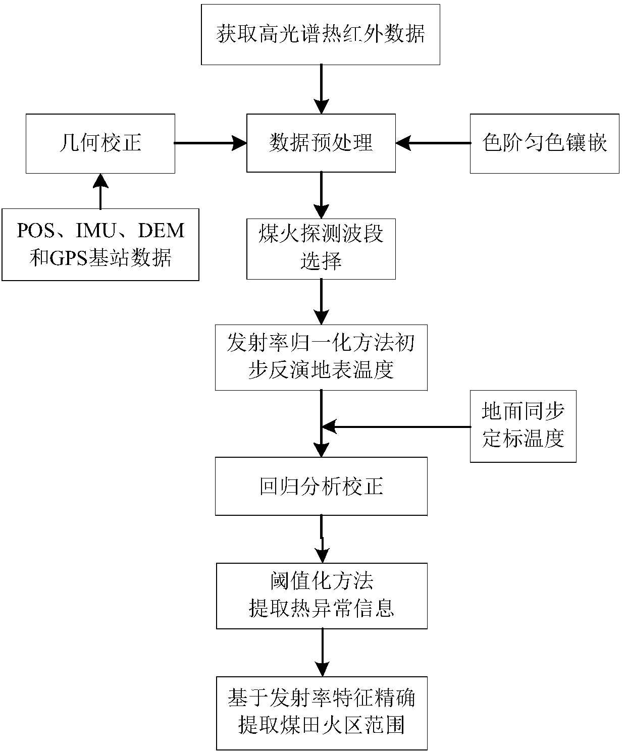
[0072] Airborne thermal infrared hyperspectral remote sensing quantitative detection method for coalfield fire area, the process is as follows figure 1 shown, including the following steps:

[0073] Step 1: Data Acquisition

[0074] The known laser generator and blackbody are used to perform laboratory spectral calibration and radiometric calibration of the sensor. The low-temperature blackbody reference source is set at 0°C, and the high-temperature blackbody reference source is set at 100°C to ensure the distinguishability of low-temperature and high-temperature features. Select an area with obvious linear targets on the ground to perform sensor geometric parameter correction flight to obtain correction data. Acquisition of hyperspectral data is carried out according to the designed flight route. At the same time, a high-sensitivity infrared radiation spot thermometer is used to measure the ground synchronous temperature as the calibration data of hyperspectral data.

[00...


PUM


Abstract

The invention belongs to the technical field of remote sensing detection, and particularly relates to an airborne thermal infrared hyperspectral remote-sensing quantitative detection method for the coal field fire zone. According to the airborne thermal infrared hyperspectral remote-sensing quantitative detection method for the coal field fire zone provided in the invention, the problem that the combustion position and the combustion range of the coal fire cannot be quickly and accurately positioned in the complex and dangerous environment of the coal field fire zone in the prior art can be solved. The method comprises the steps of 1, acquiring data; step 2, performing geometric correction and image uniform-color embedding; 3, selecting a coal fire detection waveband; 4, obtaining an earthsurface temperature inversion model; 5, extracting the thermal anomaly information; 6, accurately extracting the range of the coal field fire zone based on emissivity characteristics. In this way, the quantitative detection of the coal field fire zone can be realized, and the range of the coal field fire zone can be detected accurately. The method is concise and simple in steps, and can be completely applied to the detection of the coal field fire zone based on the thermal infrared hyperspectral remote-sensing technology. Therefore, the method provides real-time supporting data for the fire extinguishing engineering of the coal field fire zone.

Description

technical field [0001] The invention belongs to the technical field of remote sensing detection, and in particular relates to an airborne thermal infrared hyperspectral remote sensing quantitative detection method in a coal field fire area. Background technique [0002] my country has the largest reserves of coal resources in the world. However, the spontaneous combustion of coal fires is very serious, which not only causes a huge waste of coal resources, but also poses a great pollution to the environment. Scholars at home and abroad use remote sensing technology to identify and monitor coalfield fire areas, mainly relying on multi-spectral and medium-low resolution remote sensing images, which can only provide qualitative or semi-quantitative information on the location of fire sources and the approximate range of fire areas, which is difficult to meet the requirements of coalfield fire area monitoring. Increasing demands for precision and accuracy. The conventional remot...

Claims


Application Information

Patent Timeline
IPC IPC(8): G01J5/00
CPCG01J5/0018
Inventor 杨国防赵英俊张鑫田新光
Owner BEIJING RES INST OF URANIUM GEOLOGY
Learn More