A system and method for matching coordinates and administrative regions

A technology of administrative regions and matching methods, applied in the field of geographic information, can solve the problems of many administrative regions in the country, large space complexity, and difficulty in point set data

Active Publication Date: 2021-09-10
江明华
View PDF6 Cites 0 Cited by
  • Summary
  • Abstract
  • Description
  • Claims
  • Application Information

AI Technical Summary

Problems solved by technology

This scheme is a geometric algorithm of points and surfaces, with complex dimensions and a large amount of calculation
[0006] The above methods are very unsatisfactory, very CPU-intensive, and can only be used for accessing small amounts of data
[0007] Among them, A: With the help of a third-party map engine, it is dependent on the map engine, and the application of the advanced features of the map engine is not easy to master. Secondly, this solution is computationally intensive and time-consuming, and cannot meet the needs of big data
[0008] B: With the help of the location service interface provided by the third-party map provider, it is a third-party service interface. It is provided through the service interface, which is time-consuming, slow in response, and cannot meet the needs of big data; the number of visits is limited. After reaching a certain amount, you must TOLL
[0009] C: Realize it by yourself through the algorithm, it is difficult to obtain the national administrative region data, and it is difficult to maintain the national administrative region point set data; the national administrative region, the point set that forms a large area is too large, consisting of tens of thousands or hundreds of thousands of points, it is not easy to maintain; the whole country There are too many administrative regions, and the space complexity is large; the matching amount is too large, and the time complexity is high, which is not suitable for large data requirements
[0010] The matching between latitude and longitude points and administrative regions is the matching between points and planes. It is a geometric calculation in three-dimensional space. The time complexity and space complexity are very high. It is difficult to find a better geometric algorithm in three-dimensional space, and the results are very good. micro

Method used


Image

  • A system and method for matching coordinates and administrative regions
  • A system and method for matching coordinates and administrative regions
  • A system and method for matching coordinates and administrative regions

Examples


Embodiment Construction

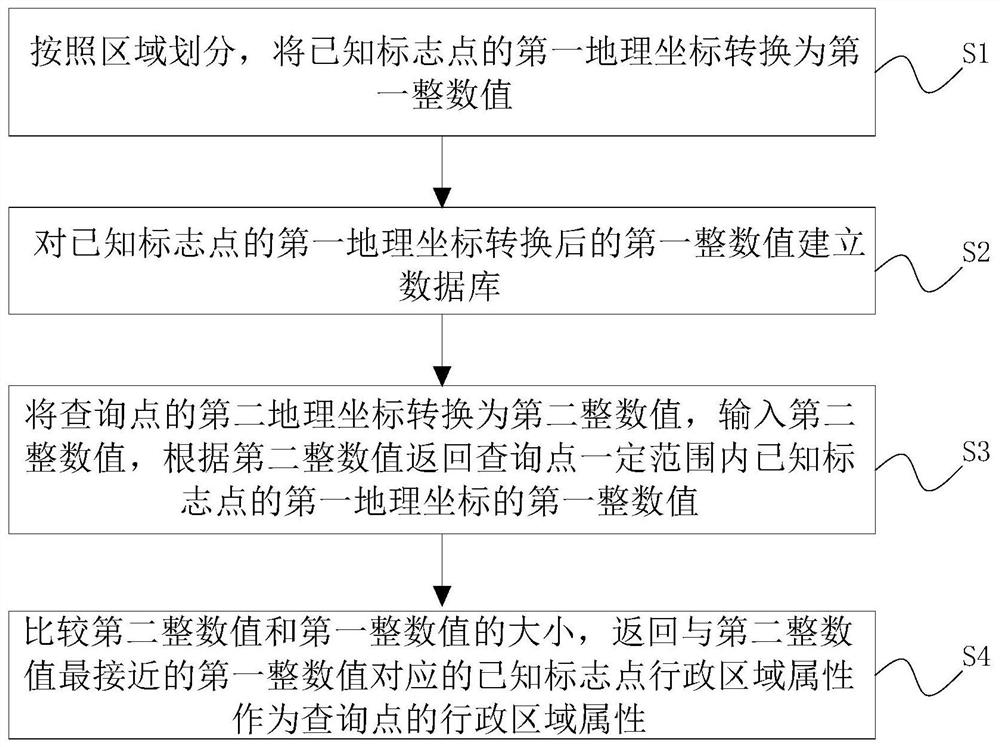
[0030] The following examples are used to illustrate the present invention, but are not intended to limit the scope of the present invention.

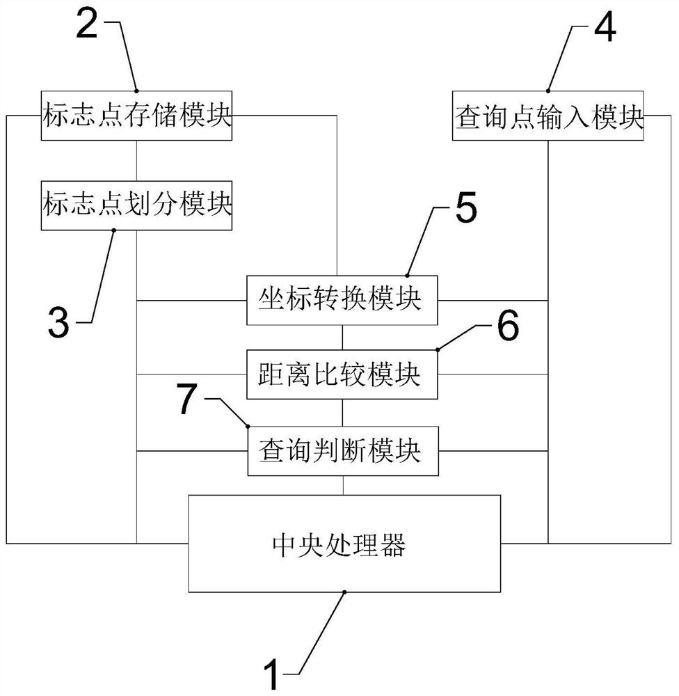
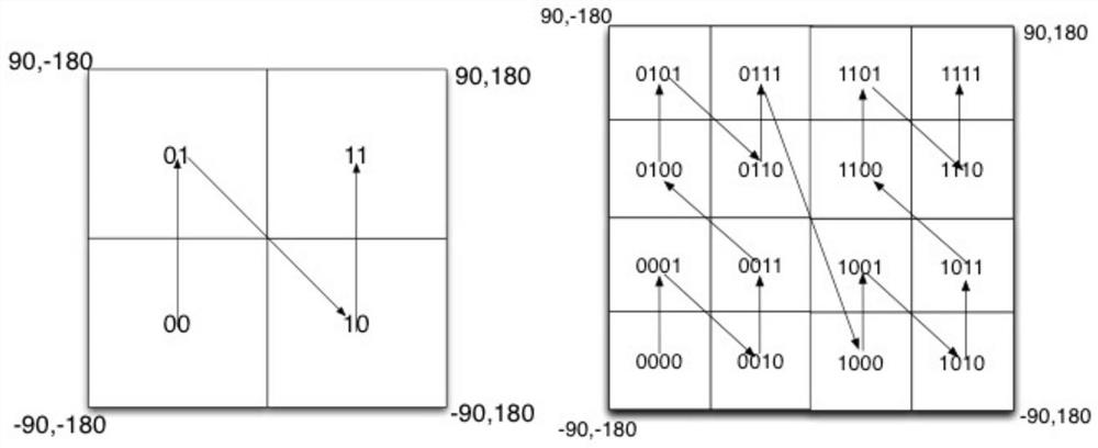
[0031] Such as figure 1As shown, a coordinate and administrative area matching system, the matching system includes a server host, the server host is provided with a central processing unit 1, the matching system includes a marker point storage module 2, a marker point division module 3, a query point input module 4, a coordinate The conversion module 5 and the distance comparison module 6; the marker point storage module 2 is arranged on the upper end of the server; The coordinates of some marker points; the marker point division module 3 is arranged on the server upper end, and the marker point division module 3 establishes a connection relationship with the marker point storage module 2, and the marker point division module 3 is used to carry out regionalization on the marker points stored in the marker point storage module 2 Divis...


PUM


Abstract

The invention discloses a system and method for matching coordinates and administrative regions. The method converts the first geographic coordinates of known marker points into first integer values ​​according to the division of regions; The first integer value establishes the database; the second geographic coordinates of the query point are converted into the second integer value, the second integer value is input, and the first geographic coordinates of the known marker points within a certain range of the query point are returned according to the second integer value. An integer value; compare the size of the second integer value with the first integer value, and return the administrative area attribute of the known marker point corresponding to the first integer value closest to the second integer value as the administrative area attribute of the query point. Compared with the traditional method, the present invention has a qualitative change in space and time complexity, avoids the calculation of three-dimensional space, turns to solve in two-dimensional space, compares the size in one-dimensional space to obtain the optimal solution, and makes the space complexity with an order of magnitude reduction in time complexity.

Description

technical field [0001] The invention relates to the technical field of geographic information, can be applied to the fields of intelligent transportation, freight logistics and the like, and specifically relates to a system and method for matching coordinates and administrative regions. Background technique [0002] The matching of the coordinates and the administrative area means that by inputting a certain geographical coordinate information, the attribute of the administrative area where the geographical coordinate information is located can be returned. Existing technical solutions generally have three implementation methods: [0003] A: With the help of a third-party map engine, such as MapX Gis, Arc Gis map engine, load the area layer data of the local map data, and then input the latitude and longitude through the matching interface between points and areas opened by the map engine, and return the current latitude and longitude and the administrative area Intersectio...

Claims


Application Information

Patent Timeline
Patent Type & Authority Patents(China)
IPC IPC(8): G06F16/29G06F16/9537
CPCG06F16/29G06F16/9537
Inventor 江明华
Owner 江明华
Why Eureka
Try Eureka