Comprehensive acquisition and analysis method of high-precision spatial big data of urban 3D buildings

A technology of comprehensive acquisition and analysis methods, applied in the directions of image data processing, geographic information database, structured data retrieval, etc., can solve the problem of lagging behind in big data acquisition, integration and display, less attention to the mutual influence of various data systems in urban space, The lack of urban geographic spatial coordinates and other issues achieves the effects of rapid acquisition and intuitive query display, which is conducive to classification management and selection operations, and facilitates data input and output

Active Publication Date: 2021-06-01
SOUTHEAST UNIV
View PDF6 Cites 0 Cited by
  • Summary
  • Abstract
  • Description
  • Claims
  • Application Information

AI Technical Summary

Problems solved by technology

[0004] At present, domestic and foreign studies on urban 3D building high-precision spatial large databases mainly focus on the collection, analysis, and visualization of single data, less attention is paid to the mutual influence relationship between various data systems in urban space, and there is even a lack of comprehensive urban space at the level of 3D buildings. Production and dynamic display technology of overlaid three-dimensional building high-precision spatial large database
In the acquisition of high-precision spatial large databases of urban 3D buildings, there is a lack of urban geographic spatial coordinates, data processing in a single dimension, and lagging behind in the field of urban spatial big data acquisition, integration and display of large-scale composite data

Method used


Image

  • Comprehensive acquisition and analysis method of high-precision spatial big data of urban 3D buildings
  • Comprehensive acquisition and analysis method of high-precision spatial big data of urban 3D buildings
  • Comprehensive acquisition and analysis method of high-precision spatial big data of urban 3D buildings

Examples


Embodiment Construction

[0039] In order to describe the technical solution disclosed in the present invention in detail, further elaboration will be made below in conjunction with the accompanying drawings and specific embodiments.

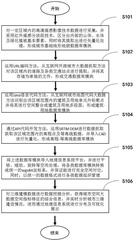
[0040] The comprehensive acquisition and analysis method of the three-dimensional building high-precision spatial big data in the city of Hangzhou, China (total area 16,596 square kilometers, permanent population 9.188 million, urbanization rate 76.2%), the data acquisition process of the present invention is as follows figure 1 As shown, the specific operation steps are as follows:

[0041] (1) Collect the high-definition remote sensing image data within the urban area of ​​Hangzhou, and use infrared remote sensing sub-band technology to distinguish the basic elements of internal mountains, water bodies and green vegetation, and extract them and vectorize them to form Terrain database modules, such as image 3 shown;

[0042] (1.1) Collect the technical data of high-def...


PUM


Abstract

The present invention disclosed the comprehensive collection and analysis method of high -precision space big data in the city's three -dimensional building.4 Land database; (4) build high -end databases such as high -end ‑; (5) Establish a three -dimensional model of the city to form a high -precision space big data of the three -dimensional building of the city;The present invention can deal with the processing of massive space form data, carry out a fast and efficient urban three -dimensional building high -precision space big data acquisition and the measurement of spatial structure elements, and realize the comprehensive collection and information synthesis of basic data based on urban spatial analysis based on artificial intelligence systems.It helps the comprehensive, standardized and efficient operation of urban planning and design.

Description

technical field [0001] The invention relates to a mining, collection and analysis of urban spatial big data, in particular to a comprehensive collection and analysis method of urban three-dimensional building high-precision spatial big data. Background technique [0002] Urban high-precision spatial big data with three-dimensional buildings as the smallest unit has always been the core foundation of spatial planning and even urban planning, but this database has the characteristics of difficulty in obtaining, long cycle, and small samples. In response to this problem, it is of great significance to obtain a large database of urban space by using a multi-source approach of high-tech informatization and intelligentization for the study of the evolution of urban spatial form and the internal development mechanism of the city. Compared with the role of traditional remote sensing satellite maps in distinguishing various elements of the city through infrared bands, the high-precis...

Claims


Application Information

Patent Timeline
Patent Type & Authority Patents(China)
IPC IPC(8): G06F16/29G06F16/9537G06T17/00
CPCG06F16/29G06F16/9537
Inventor 杨俊宴熊伟婷史宜曹俊
Owner SOUTHEAST UNIV
Why Eureka
Try Eureka