
Multi-source monitoring technology fusion-based ground subsidence integrated monitoring method

A technology of land subsidence, technology, applied in measurement devices, mapping and navigation, altitude/level measurement, etc., to achieve the effect of eliminating atmospheric delay

Active Publication Date: 2017-11-24
北京市水文地质工程地质大队 +1
View PDF4 Cites 46 Cited by
  • Summary
  • Abstract
  • Description
  • Claims
  • Application Information

AI Technical Summary

Problems solved by technology

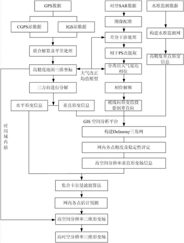
[0008] The technical problem to be solved by the present invention is to provide an integrated land subsidence monitoring method based on the fusion of multi-source monitoring technologies, so that the existing subsidence monitoring technologies can be organically integrated, and the subsidence information obtained by various monitoring means can be data fused. Obtain large-scale, high-precision, high-spatial-resolution three-dimensional surface deformation information, thereby overcoming the shortcomings of existing land subsidence monitoring methods

Method used


Image

  • Multi-source monitoring technology fusion-based ground subsidence integrated monitoring method
  • Multi-source monitoring technology fusion-based ground subsidence integrated monitoring method
  • Multi-source monitoring technology fusion-based ground subsidence integrated monitoring method

Examples


Embodiment Construction

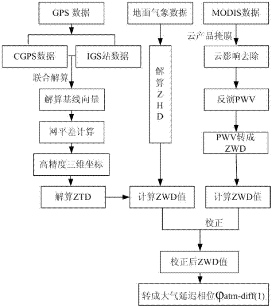
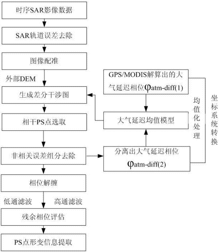
[0050] The specific steps of the invention of the land subsidence integrated monitoring method are described in detail in conjunction with the accompanying drawings.

[0051] Refer to attached figure 1 As shown, the ground subsidence integrated monitoring method of the present invention comprises the following steps:

[0052] 1) Lay out benchmarking points, GPS points and artificial corner reflector (CR)-GPS-leveling integrated points

[0053] Firstly, precision leveling points and GPS monitoring points are arranged in the key monitoring areas of land subsidence for ground subsidence monitoring; CR-GPS-leveling integrated points are arranged in areas with relatively stable ground surface, which can be used as reference points for subsidence monitoring and air-ground monitoring points. Integral connection reference point. And the CR-GPS-leveling integrated point can unify the subsequent GPS measurement data and InSAR data into the same reference coordinate system, and the GPS...


PUM


Abstract

The invention discloses a multi-source monitoring technology fusion-based ground subsidence integrated monitoring method. The method comprises laying benchmarks and GPS monitoring points in a ground subsidence focal monitoring area, laying a CR-GPS-benchmark integrated point in a ground stable region, in the same time sequence, acquiring GPS data, ground meteorological data, MODIS data, SAR images and leveling data, calculating GPS data through the combination of synchronous observation data from surrounding CGPS stations and IGS stations and ground meteorological data, calculating atmospheric delay phase information through the combination of GPS data, ground meteorological data and MODIS data, extracting stable PS point and PS point deformation information in an initial differential interferometric phase map, building a ground subsidence vertical deformation field through deformation formation corresponding to the PS points, GPS points, benchmarks and integrated points, constructing a spatial data field through fusion of a horizontal deformation field and a vertical deformation field and acquiring ground subsidence three-dimensional deformation field information having high temporal-spatial resolution. The method can acquire ground three-dimensional deformation information with a large range, a high precision and high temporal-spatial resolution.

Description

technical field [0001] The invention relates to the field of land subsidence monitoring, in particular to an integrated monitoring method of land subsidence based on fusion of multi-source monitoring technologies. Background technique [0002] At present, the monitoring methods of land subsidence mainly include precision leveling survey, bedrock marker-layer marker survey, GPS survey and synthetic aperture radar differential interferometry (InSAR). [0003] Among them, the precision leveling survey obtains the surface deformation information by laying out graded leveling network, adjustment calculation and spatial interpolation. The land subsidence information obtained by this method has high accuracy and reliability, but due to its long re-measurement cycle, manpower The huge consumption of material resources, the inability to meet the requirements of real-time dynamic monitoring of land subsidence, and the discontinuous monitoring information obtained limit the wide applic...

Claims


Application Information

Patent Timeline
IPC IPC(8): G01C5/00G01D21/02
CPCG01C5/00G01D21/02
Inventor 叶超雷坤超罗勇崔文君陈蓓蓓王荣田芳周毅王新惠田苗壮
Owner 北京市水文地质工程地质大队
Learn More