
Method for automatically extracting point clouds of electric tower from airborne LiDAR data

A technology of automatic extraction and electric tower, applied in the direction of computer parts, instruments, characters and pattern recognition, etc., can solve problems such as manual inspection and maintenance difficulties

Active Publication Date: 2017-10-20
INST OF REMOTE SENSING & DIGITAL EARTH CHINESE ACADEMY OF SCI
View PDF2 Cites 17 Cited by
  • Summary
  • Abstract
  • Description
  • Claims
  • Application Information

AI Technical Summary

Problems solved by technology

[0002] With the rapid development of the national economy and the substantial expansion of high-voltage and ultra-high-voltage power lines, transmission line corridors often need to pass through various complex geographical environments, which brings a lot of difficulties to traditional manual inspection and maintenance.

Method used


Image

  • Method for automatically extracting point clouds of electric tower from airborne LiDAR data
  • Method for automatically extracting point clouds of electric tower from airborne LiDAR data
  • Method for automatically extracting point clouds of electric tower from airborne LiDAR data

Examples


Embodiment Construction

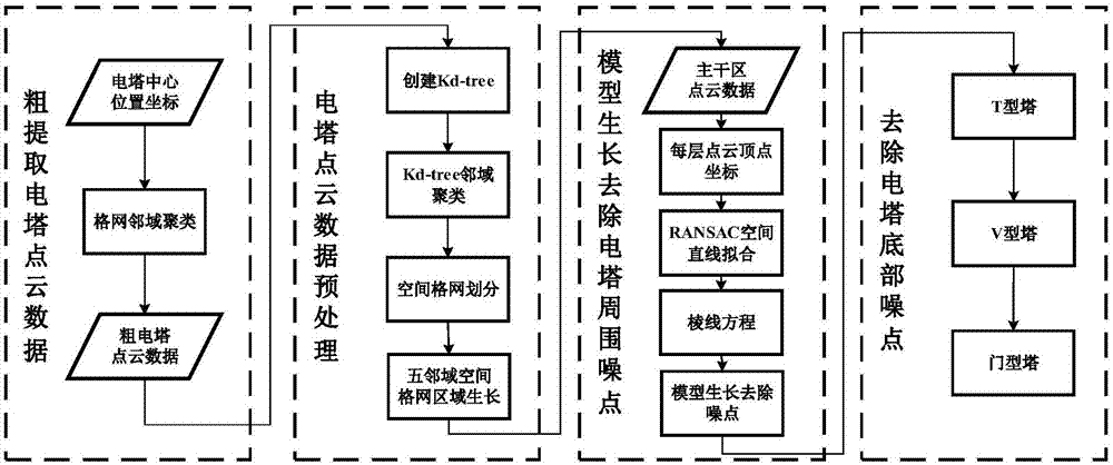
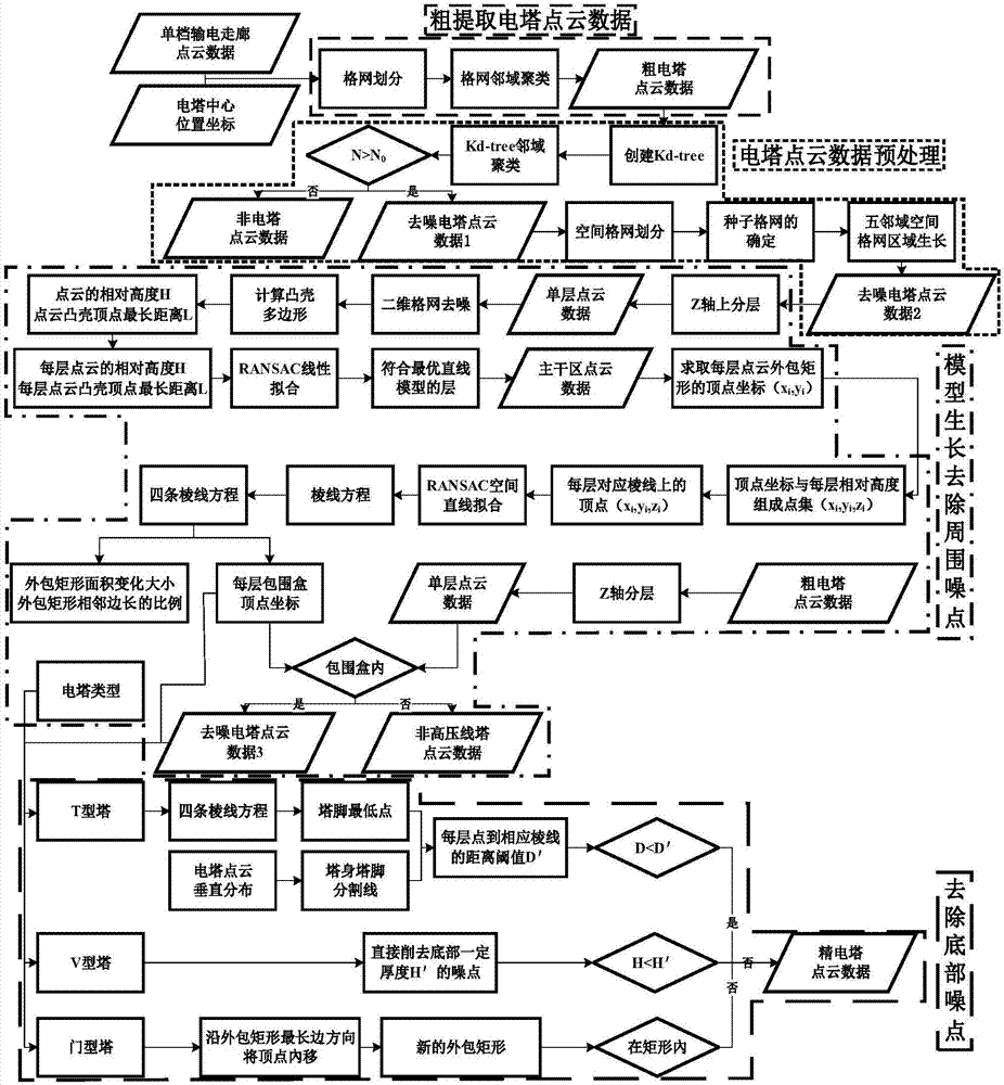
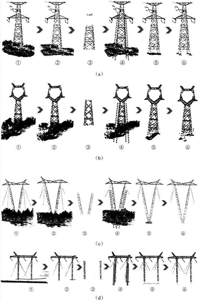
[0009] The general idea of ​​the patent of the present invention is: according to the spatial geometric characteristics and point cloud distribution characteristics of the tower and surrounding terrain and features, based on the plane grid neighborhood clustering, Kd-tree clustering, spatial grid area growth, and RANSAC linear fitting and the model growth method. The automatic extraction of tower point clouds is mainly divided into four steps: rough extraction of tower point clouds based on plane grid neighborhood clustering, point cloud data preprocessing based on Kd-tree clustering and spatial grid growth, and tower based Geometric features and RANSAC algorithm point cloud extraction of tower backbone area and fine extraction of tower point cloud data based on model growth. figure 1 It is the general flowchart of tower point cloud extraction, figure 2 It is a detailed flow chart of tower point cloud extraction, image 3 Example extraction process for different types of to...


PUM


Abstract

The invention discloses a method for automatically extracting point clouds of an electric tower from airborne LiDAR data. The electric tower is important contents in high-voltage line patrol. Based on the plane position and spatial geometric characteristics of the electric tower, a method for extracting the electric tower from point clouds of an airborne laser radar is proposed and comprises the steps of (1) performing electric tower point cloud coarse extraction on original point cloud data, obtained by the airborne laser radar, of a power transmission line according to a two-dimensional grid neighborhood clustering method; (2) preprocessing a coarse extraction result by adopting Kd-tree clustering and spatial grid region growth methods; (3) through a spatial geometric structure of the electric tower, extracting a main region of the electric tower, and determining a tower body edge line equation in combination with an RANSAC spatial linear fitting method; and (4) removing noisy points based on growth of a point cloud model of a main region of a line tower, and removing bottom noisy points of the electric tower by adopting a specific method in combination with different bottom structures of the electric tower, thereby finishing fine extraction of the point clouds of the electric tower. According to the method, fine classification of the point clouds of the electric tower is realized directly through structural characteristics of the point clouds of the electric tower; the problem of relatively poor quality of point cloud data of the electric tower can be solved to a certain extent; and the classification efficiency and precision are high.

Description

Technical field [0001] The patent of the present invention is a technology in the field of earth observation, and relates to a classification method for automatically extracting tower point clouds from airborne LiDAR point cloud data of high-voltage and ultra-high-voltage transmission lines. This method has certain universality and is a method with theoretical research and practical application value. Background technique [0002] With the rapid development of the national economy and the substantial expansion of high-voltage and extra-high-voltage power lines, transmission line corridors often need to pass through various complex geographical environments, which brings a lot of difficulties to traditional manual inspection and maintenance. How to quickly, accurately, and real-time monitor the operation status of transmission lines is a major problem in the power industry. In recent years, with the in-depth development of airborne LiDAR technology in power line inspection, ...

Claims


Application Information

Patent Timeline
IPC IPC(8): G06K9/46G06K9/62G06K9/40G06K9/00
CPCG06V20/176G06V10/30G06V10/44G06F18/232G06F18/231G06F18/24
Inventor 王成李雪松习晓环
Owner INST OF REMOTE SENSING & DIGITAL EARTH CHINESE ACADEMY OF SCI
Learn More