DSM-based unmanned aerial vehicle flight safety zone calculation display method

A flight safety, calculation and display technology, applied in the field of traffic information, can solve the problems of high cost, lack of precise expression of ground object elevation information, and failure to take into account the elevation difference of different floors, etc., to simplify processing work, simplify DSM data processing, improve The effect of precision

Active Publication Date: 2017-10-10
QIANXUN SPATIAL INTELLIGENCE INC
View PDF9 Cites 9 Cited by
  • Summary
  • Abstract
  • Description
  • Claims
  • Application Information

AI Technical Summary

Problems solved by technology

For example, for the taller street trees in the urban green belt, if each street tree is regarded as a feature object and given an elevation, the cost is very high;
[0006] The second is that the simple cylinder model based on vector ground objects plus elevation is not precise enough for the expression of ground object elevation information
For example, if a g

Method used


Image

  • DSM-based unmanned aerial vehicle flight safety zone calculation display method
  • DSM-based unmanned aerial vehicle flight safety zone calculation display method

Examples


Embodiment Construction

[0035] Hereinafter, the present invention will be further described in conjunction with the drawings and embodiments.

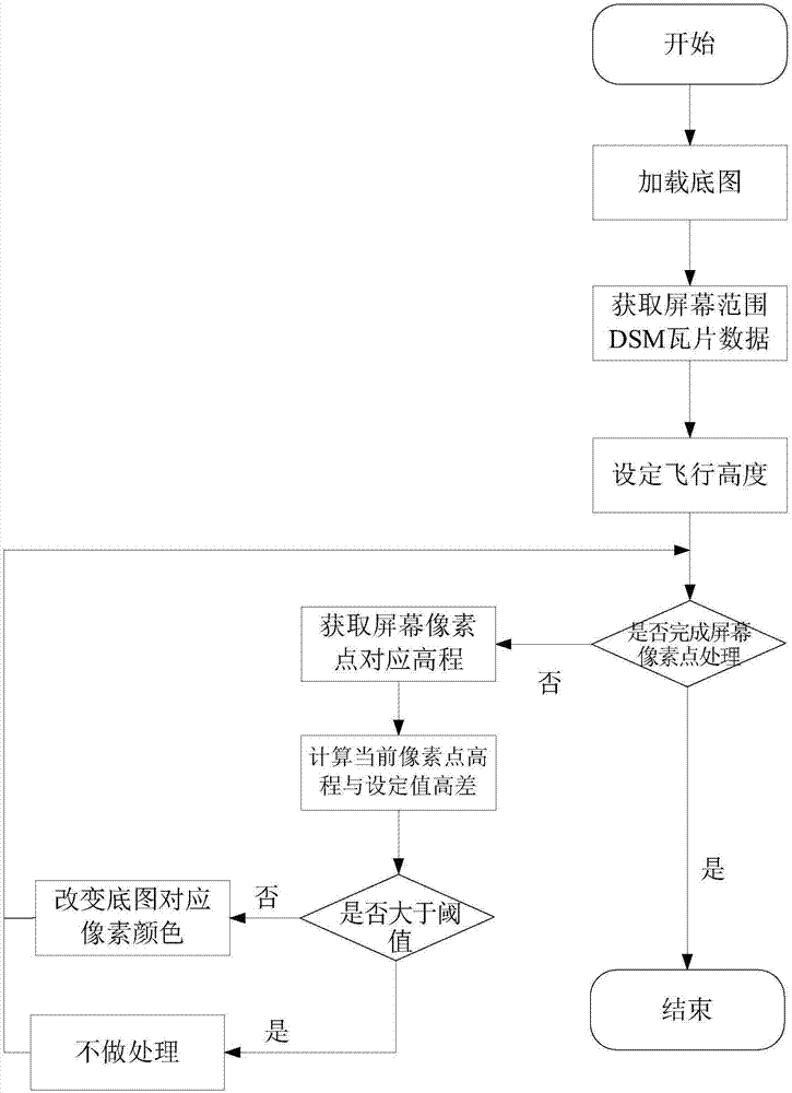
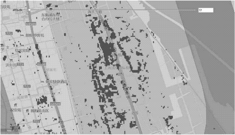
[0036] figure 1 It is a flow chart of the present invention, initially loading an online map from a map server as a raster base map for display, and simultaneously calling a feature elevation data service to load high-precision DSM tile data within the spatial range of the map window as basic data for subsequent calculations. After the user sets the flight height of the drone through the human-computer interaction interface on the web side, the system obtains the elevation value corresponding to each pixel in the screen range in real time through coordinate conversion and combined with DSM data, and calculates the difference between the elevation value and the set height Value, according to certain rules to decide whether to change the color of the current basemap pixel to remind the user. After the traversal operation is completed, the system rendering proc...


PUM


Abstract

The invention provides a DSM-based unmanned aerial vehicle flight safety zone calculation display method. An online map is loaded from a map server as a basic base map to be displayed, and at the same time, a ground feature elevation data service is called to load high-precision DSM tile data in a map window spatial range as basic data of subsequent calculation. After a user sets flight height of an unmanned aerial vehicle at a web side through a man-machine interactive interface, through coordinate transformation, and combining with DSM data, a system obtains an elevation value corresponding to each pixel pint in a screen range in real time, calculates a difference value between the elevation value and the set height, and decides according to certain rules whether to change the color of current base map pixels to remind the user. After traversal operation is completed, the system renders a processing result and outputs the result to a screen to be displayed, and distinguishes the general situation of a flight zone under the current set condition through color. The DSM-based unmanned aerial vehicle flight safety zone calculation display method reduces the loading amount of DSM data, simplifies the complexity of front-end calculation, and improves the calculation efficiency of the front end.

Description

technical field [0001] The invention relates to the technical field of traffic information, in particular to a DSM-based method for calculating and displaying a flight safe area of ​​an unmanned aerial vehicle. Background technique [0002] Digital Elevation Model (DEM, Digital Elevation Model) is a digital simulation of ground terrain through limited terrain elevation data (that is, the digital expression of terrain surface morphology). Solid ground model. Digital Surface Model (DSM, Digital Surface Model) refers to a ground elevation model that includes the heights of surface buildings, bridges and trees. Compared with DSM, DEM only contains the elevation information of the terrain and does not include other surface information. DSM is based on DEM and further covers the elevation of other surface information except the ground. It is the most realistic expression of ground fluctuations and is widely used in various industries. For example, in forest areas, it can be used...

Claims


Application Information

Patent Timeline
IPC IPC(8): G06T17/05G06T15/00
CPCG06T15/005G06T17/05
Inventor 陈立威
Owner QIANXUN SPATIAL INTELLIGENCE INC
Why Eureka
Try Eureka