
Open source map-based distributed GIS state monitoring system

A state monitoring and distributed technology, applied in the direction of hardware monitoring, geographic information database, data processing input/output process, etc., can solve the problems of unsure position information, easy loss of manpower and material resources, etc., and achieve intuitive and convenient operation mode Effect

Active Publication Date: 2017-09-22
浙江正泰中自控制工程有限公司
View PDF4 Cites 13 Cited by
  • Summary
  • Abstract
  • Description
  • Claims
  • Application Information

AI Technical Summary

Problems solved by technology

[0006] Existing pipeline network monitoring GIS applications need to accurately display the actual monitoring object information in the open source map. Since each enterprise only displays a small number of monitoring points, if the surveying and mapping department is entrusted to conduct surveying and mapping to obtain the latitude and longitude coordinates of each monitoring point, it is easy to lose a lot of resources. Manpower and material resources, but the monitoring points without surveying and mapping data cannot determine their accurate location information, so there is still room for improvement

Method used


Image

  • Open source map-based distributed GIS state monitoring system

Examples


Embodiment Construction

[0035] The present invention will be further described in detail below with reference to the accompanying drawings.

[0036] This specific embodiment is only an explanation of the present invention, and it does not limit the present invention. Those skilled in the art can make modifications without creative contribution to the present embodiment as required after reading this specification, but as long as the rights of the present invention are used All claims are protected by patent law.

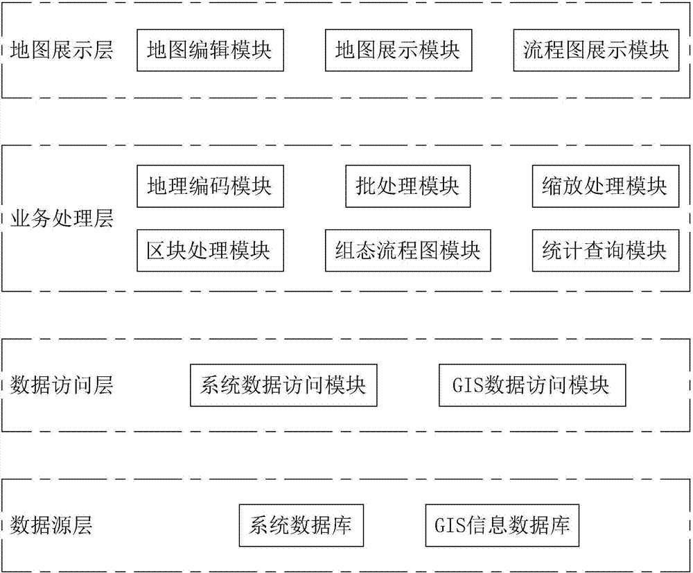
[0037] A distributed GIS state monitoring system based on an open source map disclosed in this embodiment, such as figure 1 As shown, it includes a map display layer 1, a business processing layer 2, a data access layer 3 and a data source layer 4. The map display layer 1 includes a map display module 5 for displaying the current map area, and the business processing layer 2 is used to input each The address information of the monitoring point and the reverse coordinate deduction method ar...


PUM


Abstract

The invention discloses an open source map-based distributed GIS state monitoring system, and solves the problem that position information of a monitoring point free of surveying and mapping data cannot be determined. According to the key points of the technical scheme, a map display layer comprises a map display module used for displaying a current map region; and a business processing layer is used for inputting address information of each monitoring point, performing coordinate mapping on the address information in an inverse coordinate deduction mode to determine a coordinate position, and performing display in the map display module. According to the open source map-based distributed GIS state monitoring system, the inverse coordinate deduction is that address matching is performed in a geocoding manner, conversion from known address description to corresponding longitude and latitude coordinates is performed, and point coordinates corresponding to the address are queried, so that address-to-coordinate mapping is realized; and the longitude and latitude coordinates of each monitoring point can be obtained without entrusting a surveying and mapping department to perform data surveying and mapping, so that the manpower and material resources are saved and the position information of each monitoring point can be accurately obtained.

Description

technical field [0001] The invention relates to a monitoring system, in particular to a distributed GIS state monitoring system based on an open source map. Background technique [0002] In the water industry, GIS applications mainly include two aspects: [0003] (1) Pipe network monitoring and pipe network simulation, using professional GIS maps, such as ArcGIS, requires basic product authorization and services provided by the GIS platform provider. [0004] (2) Use open source geographic information systems, such as various electronic maps, to display all distributed monitoring points, in the form of overview maps, with low investment costs. [0005] The application of GIS for pipe network monitoring has been applied in major water supply companies as early as the 1980s, and the technology is quite mature. There is a characteristic for each jurisdiction under a water group, pumping stations scattered throughout the city, pipeline inspection points, key equipment status, ...

Claims


Application Information

Patent Timeline
IPC IPC(8): G06F17/30G06F3/0481G06F3/0484G06F11/30
CPCG06F3/04812G06F3/04845G06F11/3034G06F16/29G06F16/904
Inventor 黄永忠曹福国吴晔孙权
Owner 浙江正泰中自控制工程有限公司
Learn More