Urban road network model oriented to lane-level navigation positioning

A navigation and positioning, lane-level technology, used in road network navigators, special data processing applications, instruments, etc., can solve the problem of insufficient detail and perfect road network model, redundant data structure, restricting the expansion of digital map attributes and the improvement of accuracy, etc. question

Active Publication Date: 2017-09-22
SOUTHEAST UNIV
View PDF5 Cites 10 Cited by
  • Summary
  • Abstract
  • Description
  • Claims
  • Application Information

AI Technical Summary

Problems solved by technology

[0004] However, most of the current urban road network models are not detailed enough, lack the data information required for high-precision positioning, the model structure is too single, the data structure is redundant, the accuracy is low, and the adaptability is poor.
These deficiencies greatly restrict the expansion of digital map attributes and the improvement of accuracy
In addition, in the dense traffic environment of urban buildings, the navigation and positioning satellite signals are often blocked by high-rise buildings, and the signal error is relatively large. If there are more satellites for positioning calculation, the vehicle cannot achieve accurate, continuous and real-time positioning.

Method used


Image

  • Urban road network model oriented to lane-level navigation positioning
  • Urban road network model oriented to lane-level navigation positioning
  • Urban road network model oriented to lane-level navigation positioning

Examples


Embodiment Construction

[0053] Below in conjunction with accompanying drawing and specific embodiment the present invention is described in further detail:

[0054] The present invention proposes an urban road network model oriented to lane-level navigation and positioning. The model framework is novel and reasonable, and the data structure is concise and perfect. With the advantages of complete quantity, high precision, and wide applicability, it can realize accurate, continuous, and real-time navigation and positioning of vehicles in complex urban traffic environments, and meet the needs of lane-level navigation and positioning.

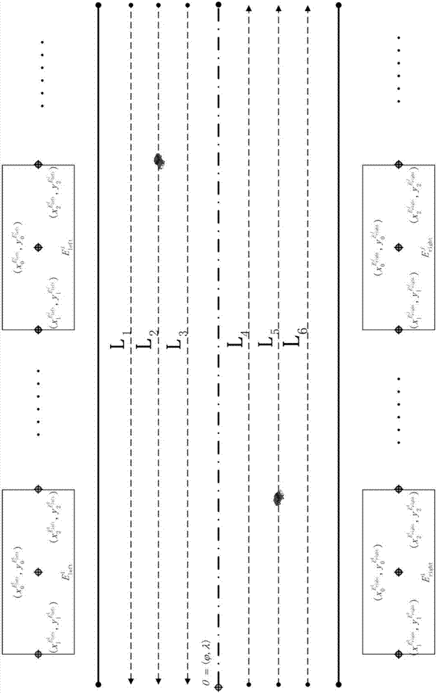
[0055] As an embodiment of the present invention, the present invention proposes as figure 1 and figure 2 Shown is an urban road network model for lane-level navigation and positioning. This model is based on the model framework and data structure of traditional road-level digital maps, and redefines the urban road network framework for the actual needs of lane-level na...


PUM


Abstract

The invention relates to an urban road network model oriented to lane-level navigation positioning. The model mainly consists of three parts including road geographic information, building information layers on two sides of a road and a road plane lane line information layer. Meanwhile, the road plane lane line information layer in the model uses a Cardinal spline interpolation algorithm for three times to fit the plane lane line of a target road, so that a line shape has the characteristics of good smoothness, continuity and plasticity, a spline curve can more favorably adapt to large urban road curvature change, and the obtained parameter can more truly reflect the plane lane current situation of the urban road. By use of the urban road network model which is put forward by the invention, the attributes of a traditional road level digital map are expanded, the accuracy of the traditional road level digital map is improved, and the model has the advantages of complete amount of information, high accuracy, wide applicability and the like, the accurate, continuous and real-time navigation positioning of a vehicle can be realized under a complex urban traffic environment, and the requirements of the lane-level navigation positioning are met.

Description

technical field [0001] The invention relates to the field of vehicle navigation and positioning, in particular to an urban road network model oriented to lane-level navigation and positioning. Background technique [0002] At present, the vigorous development of vehicle navigation and positioning technology has put forward higher requirements for digital maps. Traditional road-level digital maps can no longer meet the requirements of intelligent transportation systems (ITS Intelligent Transportation System) for positioning accuracy. Therefore, lane-level enhanced digital maps with sub-meter accuracy are being widely studied by scholars at home and abroad. Lane-level enhanced digital maps have gradually become an important information source for modern vehicle navigation and positioning systems. [0003] Lane-level enhanced digital map is a digital map that adds some unique attributes (such as road curvature, slope, lane line, etc.) on the basis of the original traditional ro...

Claims


Application Information

Patent Timeline
IPC IPC(8): G06F17/30G01C21/32
Inventor 李旭夏亮蒋荣蔡志祥
Owner SOUTHEAST UNIV
Why Eureka
Try Eureka