Method for positioning and tracking ground target by using unmanned aerial vehicle

A ground target, positioning and tracking technology, used in satellite radio beacon positioning systems, radio wave measurement systems, instruments, etc., can solve the problems of acoustic principles and installation that have great influence, unable to work alone for a long time, noise interference, etc. Reduced baseband signal processing and solution, maintains tracking capability, and enhances the effect of contributions

Active Publication Date: 2021-01-12
SHANDONG UNIV
View PDF5 Cites 1 Cited by
  • Summary
  • Abstract
  • Description
  • Claims
  • Application Information

AI Technical Summary

Problems solved by technology

INS has accumulated errors and cannot work alone for a long time. In order to weaken the accumulated errors, it is necessary to improve the accuracy of INS at a higher cost.
DVL calculates the relevant speed information by measuring the frequency shift. It has strong practicability and has a certain autonomy. However, it is greatly affected by the acoustic principle and installation, and it is prone to noise interference during speed measurement, resulting in deviation.
[0004] Due to the increasingly high requirements for high precision and high reliability of navigation and positioning systems, a single navigation system has defects in ensuring the accuracy and accuracy of positioning

Method used


Image

  • Method for positioning and tracking ground target by using unmanned aerial vehicle
  • Method for positioning and tracking ground target by using unmanned aerial vehicle
  • Method for positioning and tracking ground target by using unmanned aerial vehicle

Examples


Embodiment Construction

[0048] The following will clearly and completely describe the technical solutions in the embodiments of the present invention with reference to the drawings in the embodiments of the present invention.

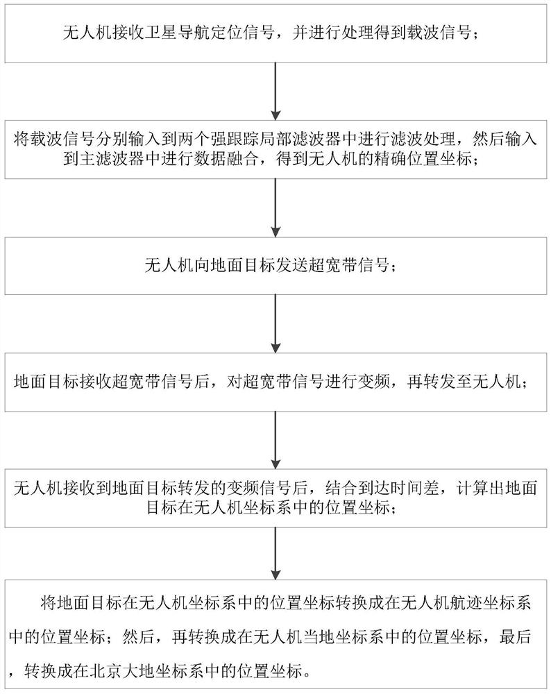
[0049] The present invention provides a kind of method that utilizes unmanned aerial vehicle to carry out the method for locating and tracking the ground target, such as figure 1 shown, including the following steps:

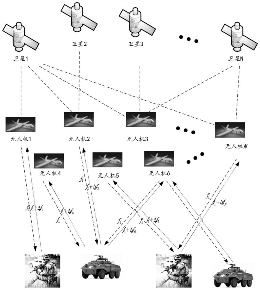
[0050] Such as figure 2 As shown, the drone in this embodiment includes a drone composed of multiple drones.

[0051] Step 1, the UAV receives the satellite navigation and positioning signal, and uses the satellite signal receiving module to process and obtain the carrier signal;

[0052] The premise of positioning in the present invention is that the satellite positioning system broadcasts satellite navigation and positioning signals in real time, and the signal sources include multi-frequency and multi-modal navigation and positioning information such as Be...


PUM


Abstract

The invention discloses a method for positioning and tracking a ground target by using an unmanned aerial vehicle, which comprises the following steps that the unmanned aerial vehicle receives a satellite navigation positioning signal and processes the satellite navigation positioning signal to obtain a carrier signal; the carrier signals are respectively input into two strong tracking local filters for filtering processing, and then the carrier signals are input into a main filter for data fusion to obtain accurate position coordinates of the unmanned aerial vehicle; the unmanned aerial vehicle sends an ultra-wideband signal to a ground target; after receiving the ultra-wideband signal, the ground target performs frequency conversion on the ultra-wideband signal and forwards the ultra-wideband signal to the unmanned aerial vehicle; after the unmanned aerial vehicle receives the frequency conversion signal forwarded by the ground target, a position coordinate of the ground target in anunmanned aerial vehicle coordinate system is calculated and into position coordinates in a Beijing geodetic coordinate system. According to the method disclosed by the invention, the accuracy and robustness of the system are greatly improved.

Description

technical field [0001] The invention relates to a method for locating and tracking a ground target, in particular to a method for locating and tracking a ground target by using an unmanned aerial vehicle. Background technique [0002] The development of navigation and positioning system is gradually developed along with the needs of people's life and production. With the continuous development of today's society, "navigation" has gradually developed from the initial guidance and direction to a variety of global The stage where the satellite navigation system and other navigation systems coexist. In recent years, whether in the military field or in civilian fields such as aviation, smart transportation, medicine, and agriculture, navigation and positioning have played a huge role, not only providing impetus for scientific and technological progress, but also providing favorable support for today's social and economic development. The vigorous development of navigation-relate...

Claims


Application Information

Patent Timeline
Patent Type & Authority Applications(China)
IPC IPC(8): G01S19/42
CPCG01S19/42
Inventor 熊海良庄众朱维红任美婷侯强王宏蕊
Owner SHANDONG UNIV
Why Eureka
Try Eureka