
A satellite integrated navigation method

A joint navigation and satellite navigation system technology, applied in the field of navigation system design, can solve problems such as long satellite deployment time, satellite function damage, and space junk generation, and achieve the goals of reducing satellite launch costs, improving resource utilization, and improving positioning accuracy Effect

Active Publication Date: 2020-01-17
HARBIN INST OF TECH SHENZHEN GRADUATE SCHOOL
View PDF5 Cites 0 Cited by
  • Summary
  • Abstract
  • Description
  • Claims
  • Application Information

AI Technical Summary

Problems solved by technology

[0004] Now only through the global navigation system can the navigation service of the target area or the whole world be realized. For our country, the Beidou satellite navigation system has the advantages of wide coverage, long working life and all-weather work, but it faces many challenges in the actual environment: 1. , The deployment time is long and the cost is high; physical and electromagnetic strikes in space will cause serious damage to satellite functions, and the communication and other functions of the satellite itself will stop serving under many interference conditions
It takes a long time to deploy satellites to make up for the missing system, and the launch cost is several times higher than that of small satellites
2. High-orbit resources are limited; all GNSS GEO synchronous satellites and IGSO satellites are in high-orbit positions, and scarce orbital resources have become the object of competition among various countries
Fourth, the navigation accuracy is limited; for the global coverage of GNSS, it is not enough to achieve high-precision navigation requirements in local areas, and for BDS that is not yet perfect, or other GNSS that lacks satellites, it is necessary to complete navigation in some blind spot areas More need for assistance from other satellites
Low-orbit small satellites have the characteristics of less deployment time, low cost, good performance, and short development cycle, as well as rich orbital resources. However, there are some disadvantages when used alone for the construction of navigation systems, such as limited coverage, Generally, there are many small satellites used in low orbits. Due to their low orbits, the coverage of the ground is limited. If the target area is large, the number of low orbit small satellites required is large, which will also cause the generation of space junk.

Method used


Image

  • A satellite integrated navigation method
  • A satellite integrated navigation method
  • A satellite integrated navigation method

Examples


Embodiment Construction

[0040] The preferred embodiments of the present invention will be further described in detail below in conjunction with the accompanying drawings.

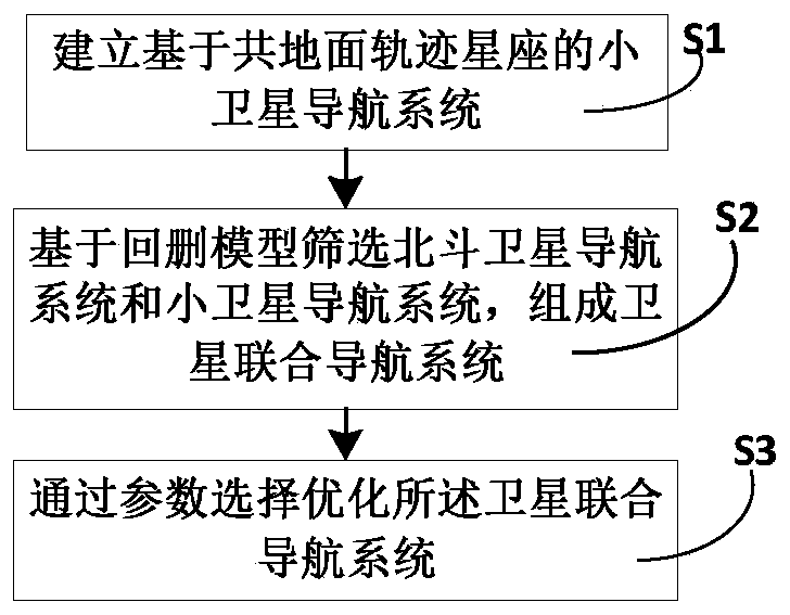
[0041] Such as figure 1 and figure 2 As shown, this example provides a satellite integrated navigation method, including the following steps:

[0042] Step S1, establishing a small satellite navigation system based on a common ground trajectory constellation;

[0043] Step S2: Screening the Beidou satellite navigation system and the small satellite navigation system based on the back-and-deletion model to form a satellite integrated navigation system; Structured navigation system, the integrated satellite navigation system is actually the integrated navigation system corresponding to the integrated satellite navigation method;

[0044] Step S3, optimizing the satellite integrated navigation system through parameter selection.

[0045] In other words, this example is mainly divided into two parts. The first part is to use the ...


PUM


Abstract

The invention provides a satellite combined navigation method comprising the following steps: S1, a small satellite navigation system based on common-ground track constellations is built; S2, a Beidou satellite navigation system is screened based on a back-tracing deletion model, and the small satellite navigation system and the Beidou satellite navigation system constitute a satellite combined navigation system; and S3, the satellite combined navigation system is optimized through parameter optimization. According to the invention, the small satellite navigation system based on common-ground track constellations is designed, and the Beidou satellite navigation system and the small satellite navigation system are combined originally through the back-tracing deletion model. The problems mainly solved are spatial fast response and coverage strengthening. When the Beidou satellite navigation system does not cover a target area, the small satellite navigation system designed based on common-ground track constellations provide fast navigation service. Under the condition that the Beidou satellite navigation system cannot meet the requirement of basic coverage or accuracy in a focus area, the positioning accuracy is improved and the cost of satellite launching is reduced through the satellite combined navigation method.

Description

technical field [0001] The invention relates to a design method of a navigation system, in particular to a design method of satellite joint navigation. Background technique [0002] Global Navigation Satellite System (GNSS) mainly includes GPS (Global Positioning System), Beidou Satellite Navigation System BDS (BeiDou Navigation System), GLONASS (GLONASS) and Galileo Satellite Navigation System (GALLILEO). Its role is to provide users with all-weather three-dimensional coordinates, speed and time information of space-based radio navigation and positioning at any place on the earth's surface or near-Earth space. In the further development process, the development of distributed satellite network, differential enhancement, inter-satellite link and other related technologies can make the satellite system's navigation and positioning capability for the region reach the meter level, which is widely used in timing, navigation, positioning, Meteorology, surveying and mapping, tran...

Claims


Application Information

Patent Timeline
Patent Type & Authority Patents(China)
IPC IPC(8): G01S19/42
CPCG01S19/423
Inventor 张钦宇胡有军张田田高厚莲张可洪靖轩
Owner HARBIN INST OF TECH SHENZHEN GRADUATE SCHOOL
Learn More