Remote sensing image-based grassland degradation degree automatic extraction method

A technology of automatic extraction of degradation degree, applied in the direction of instruments, character and pattern recognition, computer components, etc., can solve the problems of limited inversion accuracy and generalization, non-uniform degradation indicators, and fuzzy reference system, etc., to improve data processing Speed, avoiding the salt and pepper effect, and improving the recognition accuracy

Inactive Publication Date: 2017-06-27
ZHEJIANG UNIV
View PDF4 Cites 12 Cited by
  • Summary
  • Abstract
  • Description
  • Claims
  • Application Information

AI Technical Summary

Benefits of technology

This technology allows us to quickly identify areas where there are no longer enough green vegetations or trees that require maintenance without causing damage from overexposure during winters when snow falls down at nightfall. By doing this we aim to reduce costs associated with maintaining these crops while ensuring they last through harsh weather conditions.

Problems solved by technology

This patented describes various technical problem addressed during studying vegetal turf production: environmental factors affects how well it works over its lifetime; while decompositional environments like rain or snow may cause damage to crops. Current techniques involve manual assessment and analysis that require significant amounts of measuring equipment and subjective judgment. Additionally, these conventional approaches only provide direct feedback about changes caused by decomposition rather than understanding their impact on crop growth performance.

Method used


Image

  • Remote sensing image-based grassland degradation degree automatic extraction method
  • Remote sensing image-based grassland degradation degree automatic extraction method
  • Remote sensing image-based grassland degradation degree automatic extraction method

Examples


Embodiment Construction

[0029] The purpose and effects of the present invention will become more apparent by describing the present invention in detail below in conjunction with the accompanying drawings.

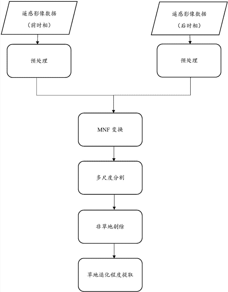
[0030] The specific process of the method in this example is as follows: figure 1 shown, including:

[0031] 1) Data acquisition: The remote sensing images used are the Lnadsat5TM images acquired in mid-August of the grassland in 2004 (front phase) and 2011 (post phase). The experimental area is located in Xilinhot City, Inner Mongolia Autonomous Region, including a variety of typical degraded grasslands and non-grass land.

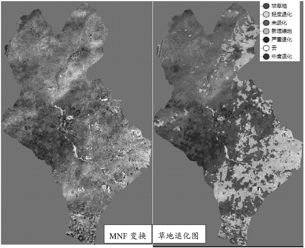
[0032] 2) Data preprocessing: Since the image quality is good, there are no abnormal bands to be eliminated, and then radiometric calibration, mosaicking, cropping, and atmospheric correction are performed on the front and rear phase images respectively. figure 2 It is the preprocessed pre-phase (left) and post-phase (right) images.

[0033] 3) Minimum noise separation tr...


PUM


Abstract

The invention discloses a remote sensing image-based grassland degradation degree automatic extraction method. The method comprises the following steps that: the satellite remote sensing image data of an area to be monitored in a front time phase and a rear time phase are obtained; the images are preprocessed, abnormal wave bands are removed, and atmospheric correction is performed; band optimization is performed by using minimum noise separation transformation, and therefore, the data can be optimized, and grassland degradation information can be integrated; segmentation scales are determined, and multi-scale segmentation is performed, so that a salt and pepper effect can be eliminated; non-grassland objects are eliminated through using a NDVI index and a band threshold value, and therefore, the influence of the non-grassland objects on extraction precision is reduced; and training samples are divided, so that grassland with different degradation degrees is extracted, so that grassland degradation degree automatic extraction can be realized. With the remote sensing image-based grassland degradation degree automatic extraction method of the invention adopted, data processing amount is decreased, extraction efficiency is improved, the salt and pepper effect is eliminated, grassland degradation information can be effectively extracted, and ideal extraction precision can be achieved.

Description


Claims


Application Information

Patent Timeline
Owner ZHEJIANG UNIV
Why Eureka
Try Eureka