
Multi-frequency data processing-based airborne D-InSar deformation detection method

A technology of data processing and detection method, applied in the field of radar, can solve the problems of the contradiction between detection accuracy and data processing difficulty, the low flight height of the airborne platform, and the difficulty of phase unwrapping, etc., so as to improve the detection accuracy and stability of the system, simplify the The effect of interfering with the data processing process and improving the detection accuracy of the system

Active Publication Date: 2017-05-24
BEIHANG UNIV
View PDF4 Cites 20 Cited by
  • Summary
  • Abstract
  • Description
  • Claims
  • Application Information

AI Technical Summary

Problems solved by technology

However, the flight altitude of the airborne platform is low. At this time, the instantaneous slant distance angle between the main and auxiliary antennas cannot be approximated to 0. If the slant distance difference is still approximated as the horizontal component of the baseline, a large system detection error will be introduced
At the same time, the track error of the airborne platform is relatively large, which brings certain difficulties to the selection of specific methods for the leveling operation.
[0004] In addition, the D-InSAR system still has the problem of the contradiction between the detection accuracy and the difficulty of data processing. The outstanding performance is that the phase unwrapping is difficult. Therefore, solving the above problems is the key to improving the detection accuracy and stability of the airborne D-InSAR system.

Method used


Image

  • Multi-frequency data processing-based airborne D-InSar deformation detection method
  • Multi-frequency data processing-based airborne D-InSar deformation detection method
  • Multi-frequency data processing-based airborne D-InSar deformation detection method

Examples


Embodiment 1

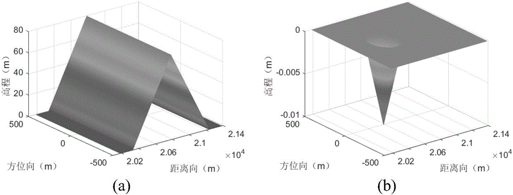
[0086] For a front and back slope scene, a concave conical deformation field is used for terrain deformation detection, and the radar imaging method is front and side view. The deformation field information such as image 3 As shown, where (a) is terrain information, and (b) is deformation field information. The distance length of the flat area on both sides of the front and rear slope terrain is 150m, the azimuth range is 1000m, the distance range is 1200m, the slope height is 80m, the deformation cone radius is 173m, and the height line is 10mm. The system parameters are set as follows: the height of the airborne platform is 12km, the platform speed is 150m / s, the downward angle of view is 60°, the pulse width of the FM signal is 500us, the bandwidth of the FM signal is 160MHz, the length of the antenna in the azimuth direction is 6m, the sampling rate in the azimuth direction is 95, and the baseline B1 is 10m , baseline angle α 1 is 0, the baseline B2 is 5m, and the basel...


PUM


Abstract

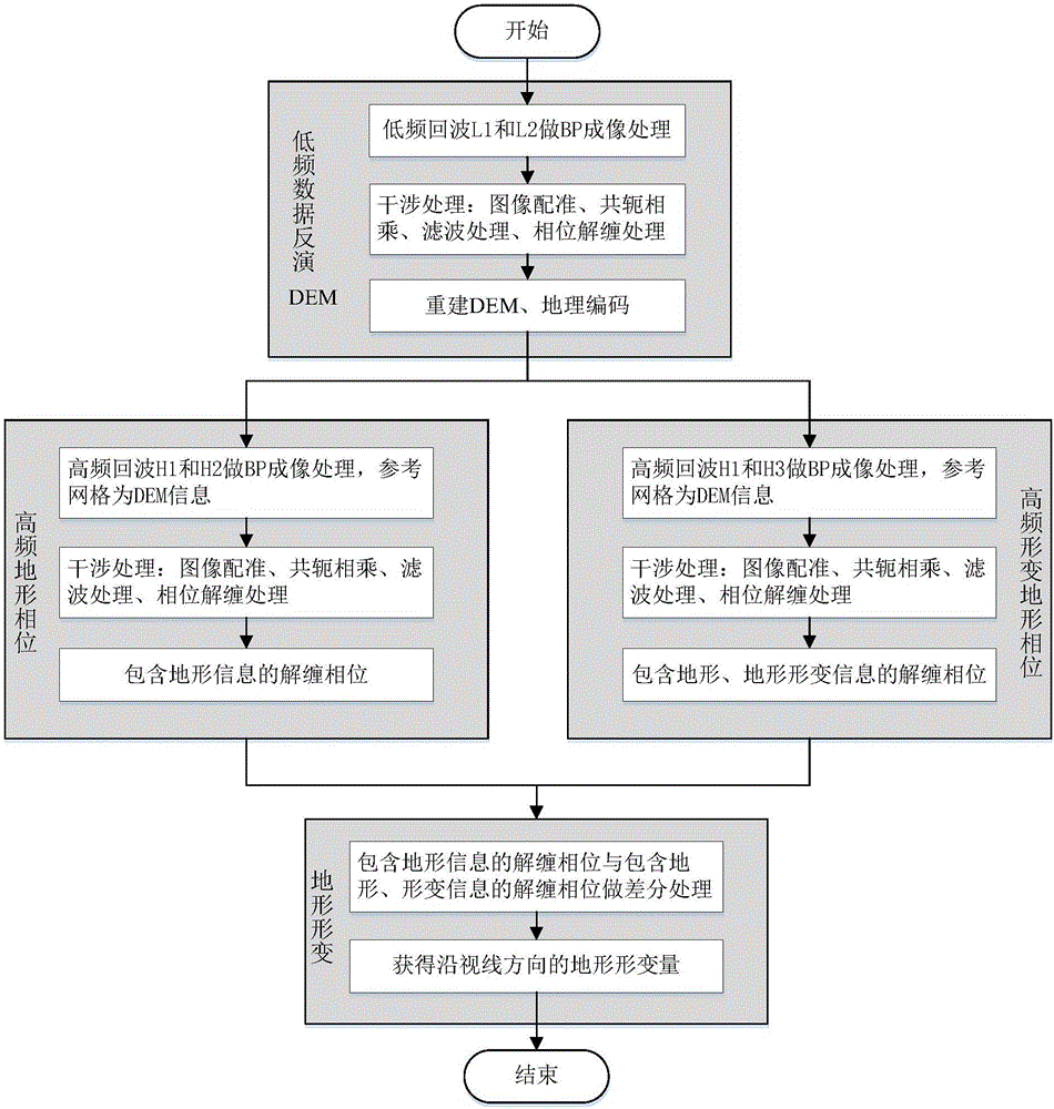
The present invention provides a multi-frequency data processing-based airborne D-InSar deformation detection method. According to the method, DEM (Digital Elevation Model) information is obtained through low-frequency echo data interference processing and inversion; the DEM information is adopted as reference rids for high-frequency echo BP imaging, so that a corresponding SAR image can be obtained; interferometric processing is performed on the SAR image, so that an interference phase containing terrain information and an interference phase containing terrain and terrain deformation information are obtained; and differential processing and inversion processing are performed on the two interference phases, so that corresponding terrain deformation variables can be obtained. With the method provided by the invention adopted, error introduced by the approximate calculation of a system can be controlled, and therefore, the detection precision of the system can be improved; contradiction between detection accuracy and data processing complexity of a traditional D-InSAR system can be alleviated; the information of high-frequency data can be obtained effectively; phase unwrapping difficulty can be reduced; the detection accuracy and stability of the system can be improved; de-grounding operation can be omitted; and flat-earth effect removal operation can be omitted; and an interference data processing flow can be simplified.

Description

technical field [0001] The present invention relates to the field of radar technology, in particular to an airborne platform, using low-frequency echo data to invert terrain DEM, using it as a BP imaging reference plane of high-frequency echo data to obtain corresponding SAR images, and obtaining them through differential interference processing High-precision terrain deformation detection method. Background technique [0002] Compared with spaceborne D-InSAR technology, the airborne D-InSAR system has the advantages of flexible orbit, short revisit period, and high detection accuracy, but at the same time, the airborne platform has problems such as low flight control capability and large track error. Therefore, how to improve The detection accuracy of the system has always been a research hotspot and difficulty. The traditional single-frequency D-InSAR system obtains terrain deformation information through steps such as SAR image registration, interference processing, de-l...

Claims


Application Information

Patent Timeline
Patent Type & Authority Applications(China)
IPC IPC(8): G01S13/90G01S13/88
CPCG01S13/885G01S13/90G01S13/9017G01S13/9023
Inventor 孙兵张洁琼许海伦左志雄
Owner BEIHANG UNIV
Learn More