
Automatic extraction and vectorization of road sill points based on vehicle-mounted laser scanning data

A vehicle-mounted laser scanning and automatic extraction technology, which is applied in the direction of measuring devices, height/level measurement, instruments, etc., can solve the problems of lack of applicability, low precision of road ridges, and low degree of automation, so as to improve the degree of automation, fast and stable Extract and vectorize effects for increased productivity

Active Publication Date: 2017-12-15
WUHAN UNIV
View PDF2 Cites 0 Cited by
  • Summary
  • Abstract
  • Description
  • Claims
  • Application Information

AI Technical Summary

Problems solved by technology

[0004] In general, there are still problems in quickly and accurately extracting road sill points from large-scale laser scanning data: (1) It is seriously affected by factors such as noise, point density changes, and occlusion, resulting in low accuracy of road sill extraction ; (2) It is only suitable for road sill extraction in certain scenarios such as urban areas, expressways, and national highways, lacking wide applicability, and low degree of automation in actual production, etc.

Method used


Image

  • Automatic extraction and vectorization of road sill points based on vehicle-mounted laser scanning data
  • Automatic extraction and vectorization of road sill points based on vehicle-mounted laser scanning data
  • Automatic extraction and vectorization of road sill points based on vehicle-mounted laser scanning data

Examples


Embodiment Construction

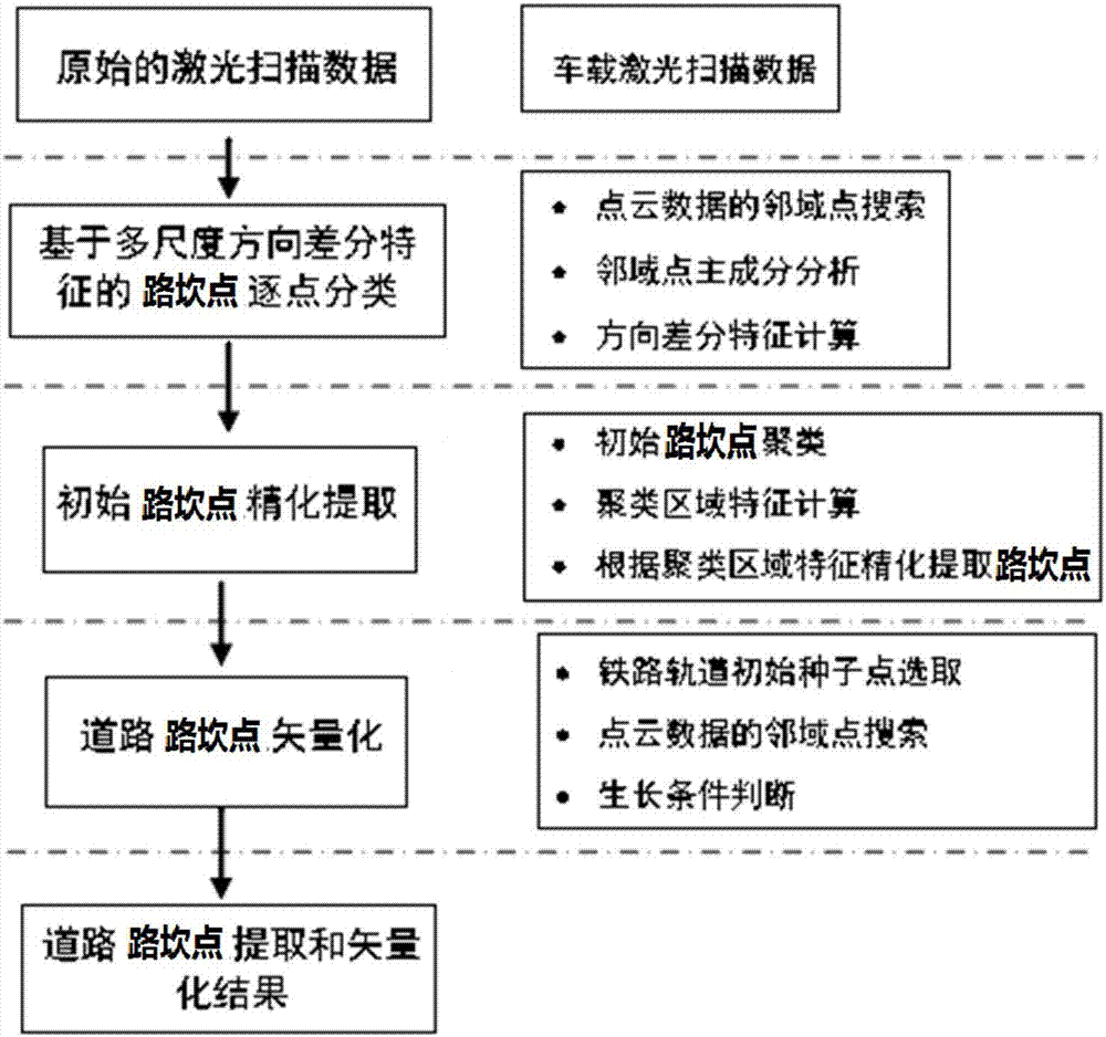
[0047] The technical scheme of the present invention adopts computer software to support the automatic operation process, and its process is as follows: figure 1 shown. The technical solution of the present invention will be described in detail below in conjunction with the embodiments and accompanying drawings. Implementation example Carry out road sill point extraction and vectorization according to the designed scheme, and the step-by-step detailed instructions are as follows:

[0048] Step 1. Calculate the features of each laser foot point in the 3D laser point cloud data.

[0049] For any laser foot point pt, the implementation of multi-scale direction difference feature calculation is as follows:

[0050] Step 1.1: Parameter initialization:

[0051] Initialize the small neighborhood radius r based on experience small = 0.3m and large neighborhood radius r large =0.5m

[0052] Step 1.2: Take the laser foot point pt as the center of the sphere, and take r small and ...


PUM


Abstract

The invention discloses a method for automatic extraction and vectorization of road junction points based on vehicle-mounted laser scanning data. feature, use the naive Bayes classifier to classify the laser footpoints into roadblock points and non-roadblock points, and the obtained roadblock points are recorded as initial roadblock points; step 3, use all initial roadblock points to build a KD tree, and for each The initial road junction points are calculated respectively for their directional characteristics; step 4, according to the directional characteristics of the initial road junction points, KD tree is used to cluster the initial road junction points; Set the conditional clustering area to obtain the extraction result of road cut points. The invention improves the automation degree and production efficiency of point cloud data processing, and the method is simple and easy to realize, and has good practical value.

Description

technical field [0001] The invention belongs to the technical field of laser scanning data intelligence, and more specifically relates to an automatic extraction and vectorization method of road ridge points based on vehicle-mounted laser scanning data. Background technique [0002] Road boundary information is one of the important components of basic geographic information. Accurate and high-precision road information plays an important role in urban planning, traffic control, and emergency response (Yang Bisheng, 2013). At the same time, the road boundary is also an important information for autonomous navigation of unmanned vehicles. It distinguishes the road area from the surrounding environment and provides feasible areas for unmanned vehicles. Semi-automatic or automatic extraction of road information based on optical images has always been a research hotspot in the field of photogrammetry and remote sensing. However, the road extraction results based on optical image...

Claims


Application Information

Patent Timeline
Patent Type & Authority Patents(China)
IPC IPC(8): G06K9/00G06K9/62G01C5/00
CPCG01C5/00G06V20/588G06F18/24155
Inventor 杨必胜袁鹏飞董震刘缘李健平
Owner WUHAN UNIV
Learn More