Geological map compilation device and method based on data driven
A data-driven, geological map technology, applied in electronic digital data processing, structured data retrieval, geographic information database, etc., can solve the problems of complex map compilation process, backward map compilation technology, low efficiency, etc., to improve map compilation. efficiency, improve timeliness, improve efficiency
- Summary
- Abstract
- Description
- Claims
- Application Information
AI Technical Summary
Problems solved by technology
Method used
Image
Examples
Embodiment 1
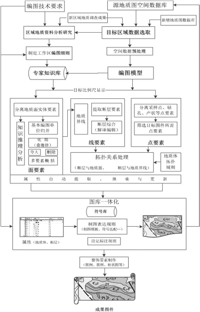
[0073] Embodiment 1: A data-driven geological map compiling device, including: a source database establishment module, a target area data selection module, a spatial data preprocessing module, a regional geological data analysis and mapping detailed rules formulation module, and a geological body evolution model module, graphics feature processing module, feature attribute update module, library Figure 1 Integrate and decorate element modules, and result forming modules.
[0074] The source database building module is used to establish a source database from the basic geological map and data update data platform, the new regional geological survey results and research results are the basic geological map and data update content;
[0075] The target area data selection module is used to update the map range according to the geological map and data, select a geological map spatial database with a scale one level larger than the compiled target geological map, and select a newer ...
Embodiment 2
[0083] Embodiment 2: A method for compiling a geological map based on data-driven, including: the step of establishing a source database, the step of selecting target area data, the step of preprocessing spatial data, the step of analyzing and researching regional geological data and formulating detailed rules for map compilation, and the evolution model of geological bodies step, graphic feature processing step, feature attribute update step, library Figure 1 Integrate and decorate element steps, result formation steps.
[0084] The step of establishing the source database is used to establish the source database from the basic geological map and the data platform for data update, the new regional geological survey results and research results are the content of the basic geological map and data update;
[0085] The target area data selection step is used to update the range of the map frame according to the geological map compilation and data, select a geological map spatial...
Embodiment 3
[0093] Embodiment 3: a spatial data preprocessing method in geological map compilation, comprising the following steps:
[0094] Steps of geographic projection conversion: organize and unify the geographic coordinate systems of the selected source data and new data, and transform the large-scale geological map spatial database into corresponding spatial coordinates according to the working target scale projection;
[0095] Steps for establishing the basic structure of data preprocessing: During the update process of the geological map spatial database, the database structure of the source data is adjusted according to the basic structure of data preprocessing; The geological surface layers of the source data are merged to form a unique geological surface layer;
[0096] The steps of topology checking: After the source database structure is adjusted, the topology is checked and corrected.
PUM
 Abstract
Description
Claims
Application Information
 - R&D
- Intellectual Property
- Life Sciences
- Materials
- Tech Scout
- Unparalleled Data Quality
- Higher Quality Content
- 60% Fewer Hallucinations
Browse by: Latest US Patents, China's latest patents, Technical Efficacy Thesaurus, Application Domain, Technology Topic, Popular Technical Reports.
© 2025 PatSnap. All rights reserved.Legal|Privacy policy|Modern Slavery Act Transparency Statement|Sitemap|About US| Contact US: help@patsnap.com


