
OBU positioning subdivision calculation method and system

A technology of positioning calculation and positioning information, which is applied in the field of traffic inspection, can solve problems such as missed tolls and untimely output of positioning information, and achieve the effect of avoiding missed tolls

Inactive Publication Date: 2016-10-19
WATCHDATA SYST
View PDF4 Cites 5 Cited by
  • Summary
  • Abstract
  • Description
  • Claims
  • Application Information

AI Technical Summary

Problems solved by technology

The method and system can solve the situation of missing charges caused by the untimely output of positioning information caused by the excessive speed of the vehicle

Method used


Image

  • OBU positioning subdivision calculation method and system
  • OBU positioning subdivision calculation method and system
  • OBU positioning subdivision calculation method and system

Examples


Embodiment Construction

[0033] The following will clearly and completely describe the technical solutions in the embodiments of the present invention with reference to the accompanying drawings in the embodiments of the present invention. Obviously, the described embodiments are only some, not all, embodiments of the present invention.

[0034] In this embodiment, the OBU automatically calculates the payment amount according to the rate table obtained from the background service system in advance to complete the payment operation, and reports the relevant data to the background service system, wherein the rate table includes toll points, toll roads, toll collection points, etc. Information such as area, toll time, toll base fee, toll model multiplier, discount type, discount rate, etc.

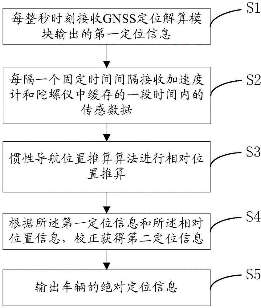
[0035] like figure 1 Shown, a kind of OBU positioning subdivision calculation method comprises the following steps:

[0036] S1. GNSS positioning calculation module outputs the first positioning information every w...


PUM


Abstract

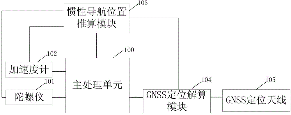
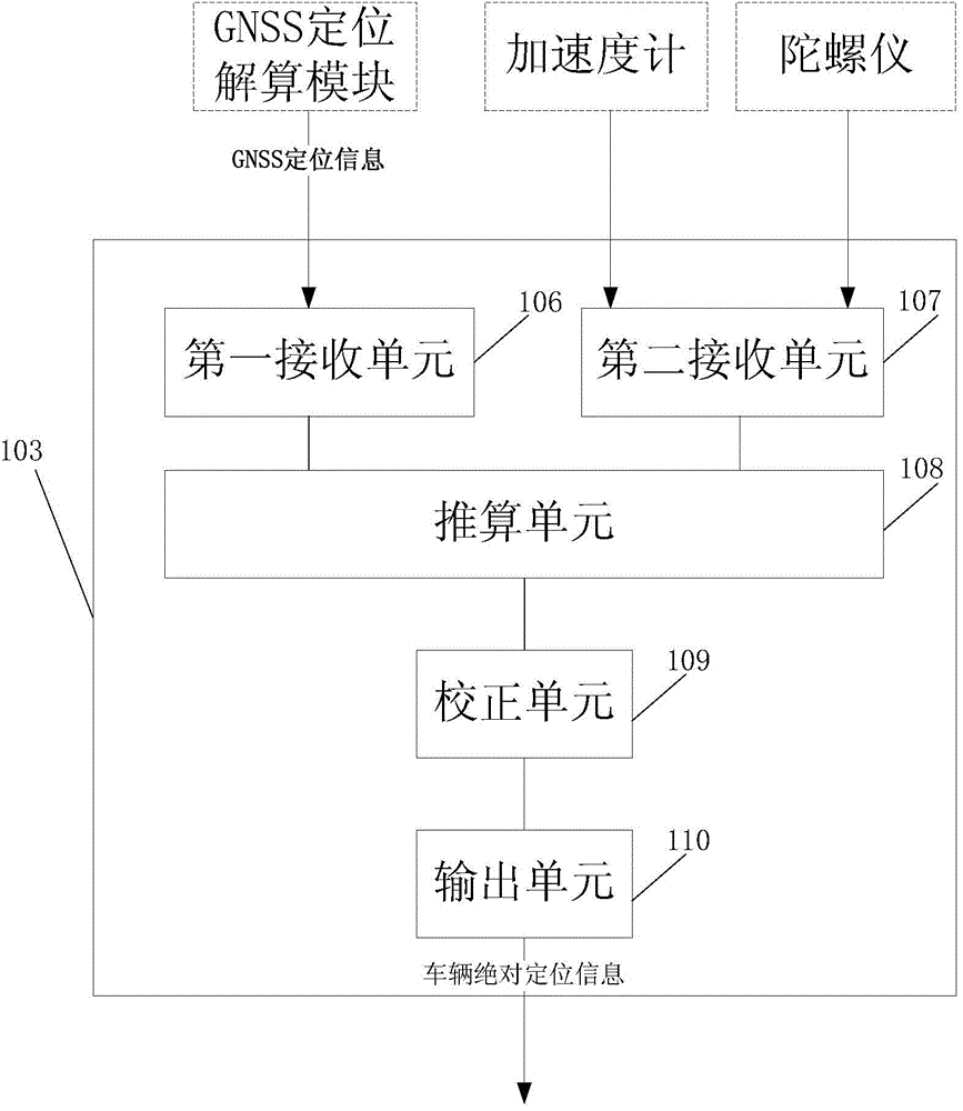
The invention relates to an OBU positioning subdivision calculation method and system. In a satellite-based charging system for a congested city, the prior art can cause miss charging when a vehicle passes a preset charging point due to the fact that positioning information is not outputted timely. The OBU positioning subdivision calculation method comprises steps of (1) receiving first positioning information outputted by a GNSS positioning calculation module per second, (2) receiving sensing data cached in a speedometer and a gyroscope after a fixed time interval, (3) calculating vehicle relative position information according to received first positioning information and sensing data cached in the speedometer and the gyroscope, (4) obtaining second positioning information by correction according to the first positioning information and the relative positioning information, (5) and outputting vehicle absolute positioning information. The OBU positioning subdivision calculation method and system can solve the problem that the positioning information is not outputted timely and prevent miss charging when the vehicle passes the preset charging point.

Description

technical field [0001] The invention belongs to the field of traffic inspection, and in particular relates to an OBU positioning subdivision and calculation method and system. Background technique [0002] At present, the charging model based on satellite positioning and navigation system is becoming more and more popular, and countries have begun to emphasize the use of a wide range, not just for a few roads or areas. Global satellite positioning and navigation systems can not only be limited to important inter-city and some rural roads, but also can be applied to urban roads, which can help alleviate traffic congestion and reduce carbon dioxide emissions. For example, Russia has approved the use of GLONASS global satellite positioning and navigation system to charge trucks on important roads; while France uses both 5.8GHz short-range dedicated communication technology and global satellite positioning technology. In addition, Singapore is exploring hybrid GPS and The 5.9GH...

Claims


Application Information

Patent Timeline
Patent Type & Authority Applications(China)
IPC IPC(8): G01S19/47
CPCG01S19/47
Inventor 李成贾安州徐海平高兴蒲强冯勇平
Owner WATCHDATA SYST
Learn More