
Multi-layer cloud and single-layer cloud type integrated classification and identification method in remote sensing image

A remote sensing image, single-layer technology, which is applied in the field of remote sensing image cloud layer recognition, can solve the problems of not giving the cloud layer type of single layer cloud in detail, and not giving the phase state of multi-layer cloud, so as to achieve the effect of enriching image information

Active Publication Date: 2016-08-31
BEIHANG UNIV
View PDF5 Cites 9 Cited by
  • Summary
  • Abstract
  • Description
  • Claims
  • Application Information

AI Technical Summary

Problems solved by technology

[0017] Although literature [2] realizes the distinction between single-layer cloud pixels and multi-layer cloud pixels, it still has the following shortcomings: this method only recognizes satellite image pixels as single-layer cloud pixels, multi-layer cloud pixels and vertical cloud pixels. Expand the three types of cloud pixels, neither the cloud type of single layer cloud nor the phase state of multilayer cloud is given in detail

Method used


Image

  • Multi-layer cloud and single-layer cloud type integrated classification and identification method in remote sensing image
  • Multi-layer cloud and single-layer cloud type integrated classification and identification method in remote sensing image
  • Multi-layer cloud and single-layer cloud type integrated classification and identification method in remote sensing image

Examples


Embodiment

[0072] The following examples illustrate the specific application process of the comprehensive multi-layer cloud and single-layer cloud type identification method proposed by the present invention.

[0073] Using the orbit (five-minute strip) data observed by the MODIS sensor on the Terra satellite on June 1, 2015 (Julian calendar 152), the observation time is 02:30-02:35 at five-minute intervals (five-minute strips), with a resolution of 5km There are two specifications of resolution 406×207 and 1km resolution 2030×1354. Figure 5 This is a MODIS RGB false-color image with large areas of cloud cover. In addition, there are many types of cloud layers in this image, and there are cases where multiple layers of cloud layers overlap. Now utilize the method proposed by the present invention to Figure 5 The 5km resolution satellite image data of the corresponding area is used to identify the phase state of multi-layer clouds and the type of single-layer clouds.

[0074] The clo...


PUM


Abstract

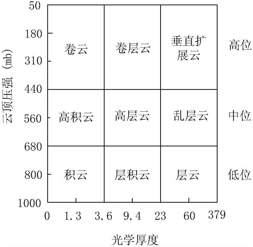
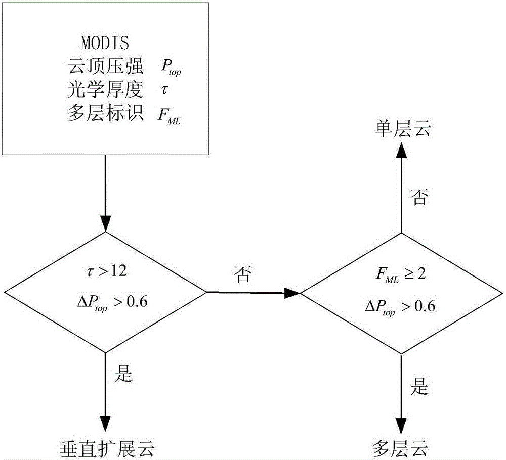
The invention discloses a multi-layer cloud and single-layer cloud type integrated classification and identification method in a remote sensing image. The method comprises: step one, carrying out cloud-included pixel element identification; step two, carrying out coarse classification and marking on single-layer and multi-layer clouds; step three, carrying out refined single-layer cloud type classification; and step four, carrying out cloud layer phase-state classification and marking. Therefore, cloud-included pixel element identification and integrated cloud layer classification and identification in a remote sensing image can be completed. According to the invention, a precise cloud layer type identification and classification result can be obtained. Distinguishing of a single-layer cloud pixel element and a multi-layer cloud pixel element can be realized; and a phase state of a multi-layer cloud pixel element and a cloud layer type of a single-layer cloud pixel element can be determined. And thus the pixel elements of the remote sensing image can be identified as thirteen kinds of pixel elements including a cloudless sky (cloud-free pixel element), a multi-layer water cloud, a multi-layer ice cloud, a cirrus cloud, a cirrostratus, a vertical extended cloud, a high cumulus cloud, an altostratus, a nimbostratus, a cumulus cloud, a stratocumulus, a stratus cloud, and a filling value, so that diversified image information can be provided for subsequent processing and application of the remote sensing image.

Description

technical field [0001] The invention relates to the technical field of cloud layer identification in remote sensing images, in particular to a method for comprehensive classification and identification of multi-layer clouds and single-layer cloud types in remote sensing images. Background technique [0002] The existence of clouds is an important interference factor affecting the imaging performance of spaceborne optical sensors for Earth observation. There are many kinds of clouds, and the spatial distribution of different types of clouds and their scattering radiation and transmission characteristics are very different. In order to study the properties of each cloud type and eliminate the influence of clouds on the observation system, the identification of cloud types has become the focus and difficulty of research ( See literature [1-2]). In addition, both space-based and ground-based sensor observations show that the existence of multilayer clouds is common and has a gr...

Claims


Application Information

Patent Timeline
IPC IPC(8): G06K9/00G06K9/62
CPCG06V20/13G06F18/241
Inventor 王虹霞许小剑
Owner BEIHANG UNIV
Learn More