Estuary-tidal-range fast prediction method
A tidal range and rapid technology, applied in the field of rapid tidal range forecasting in estuaries, can solve problems such as a large number of measured hydrological data, high computational complexity and low efficiency.
- Summary
- Abstract
- Description
- Claims
- Application Information
AI Technical Summary
Problems solved by technology
Method used
Image
Examples
Embodiment 1
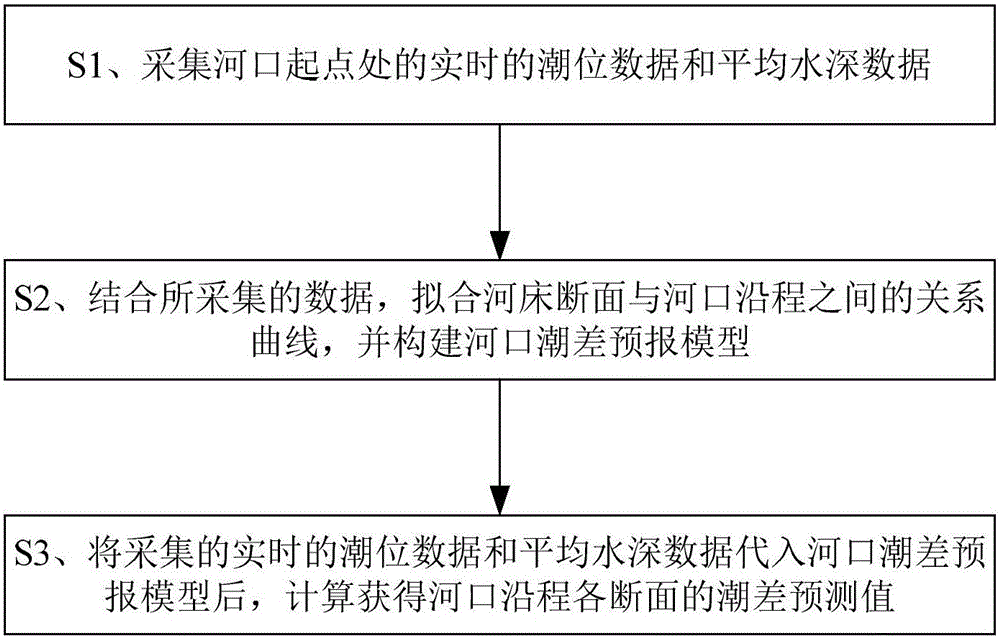
[0084] A method for rapid forecasting of tidal range in an estuary, comprising the steps of:
[0085] S1. Collect real-time tide level data and average water depth data at the starting point of the estuary;
[0086] S2. Combined with the collected data, fit the relationship curve between the section of the river bed and the distance along the estuary, and construct the tidal range forecast model of the estuary;
[0087] S3. After substituting the collected real-time tidal level data and average water depth data into the estuary tidal range prediction model, calculate and obtain the tidal range prediction value of each section along the estuary, specifically: the obtained along-course index and the collected real-time The tidal level data and average water depth data are substituted into the formula of the estuary tidal range forecasting model for solution, so as to calculate and obtain the tidal range prediction value of each section along the estuary.
[0088] In this embodi...
Embodiment 2
[0143] Taking the Pearl River estuary as an example, the method of Embodiment 1 is used to carry out dynamic forecast control of urban river flood control and drainage.
[0144] Step 1. Real-time tidal level data and average water depth data at the starting point of the estuary. The acquisition device includes a water level gauge, which can store the collected real-time rainfall data in the data memory, and collect the starting points of Lingdingyang, Modaomen and Huangmaohai in the Pearl River estuary. The tidal level, average water depth and other data at the estuary, and the measured tidal range value H at the starting point of the estuary 0 and average water depth data As shown in Table 1 below:
[0145] Table 1
[0146]
[0147] Step 2. Data transmission and reception
[0148] Using wireless communication, the collected data is sent to the data receiver of the control terminal through GPRS communication. The data receiver can include a receiving antenna, a radio st...
PUM
 Abstract
Description
Claims
Application Information
 - R&D
- Intellectual Property
- Life Sciences
- Materials
- Tech Scout
- Unparalleled Data Quality
- Higher Quality Content
- 60% Fewer Hallucinations
Browse by: Latest US Patents, China's latest patents, Technical Efficacy Thesaurus, Application Domain, Technology Topic, Popular Technical Reports.
© 2025 PatSnap. All rights reserved.Legal|Privacy policy|Modern Slavery Act Transparency Statement|Sitemap|About US| Contact US: help@patsnap.com


