
GNSS point positioning coordinate correction method based on CORS

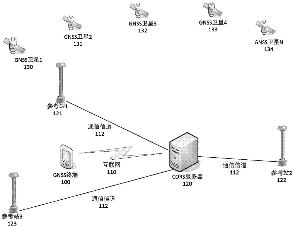
A single-point positioning and coordinate technology, applied in the field of surveying and mapping geographic information, can solve problems such as limiting the application range of RTK or RTD, failing to provide phase or pseudo-range observation values, and the difference effect is not obvious, so as to achieve easy implementation, expand the application range, Computational Model Simple Effects

Inactive Publication Date: 2016-03-30
WUHAN UNIV
View PDF5 Cites 19 Cited by
  • Summary
  • Abstract
  • Description
  • Claims
  • Application Information

AI Technical Summary

Problems solved by technology

However, the differential method requires GNSS terminals to provide original phase or pseudorange observations, which limits the application range of RTK or RTD to a large extent. For example, currently popular smartphones generally have GNSS positioning functions, but most Can only output coordinate results, not raw phase or pseudorange observations
The traditional coordinate difference requires that the two GNSS terminals must receive exactly the same satellite, otherwise the difference effect is not obvious
The precise point positioning (PPP) method not only requires the GNSS terminal to output pseudorange and phase observations, but also requires precise ephemeris and clock error, and its scope of application is further limited.

Method used


Image

  • GNSS point positioning coordinate correction method based on CORS
  • GNSS point positioning coordinate correction method based on CORS
  • GNSS point positioning coordinate correction method based on CORS

Examples


no. 1 example

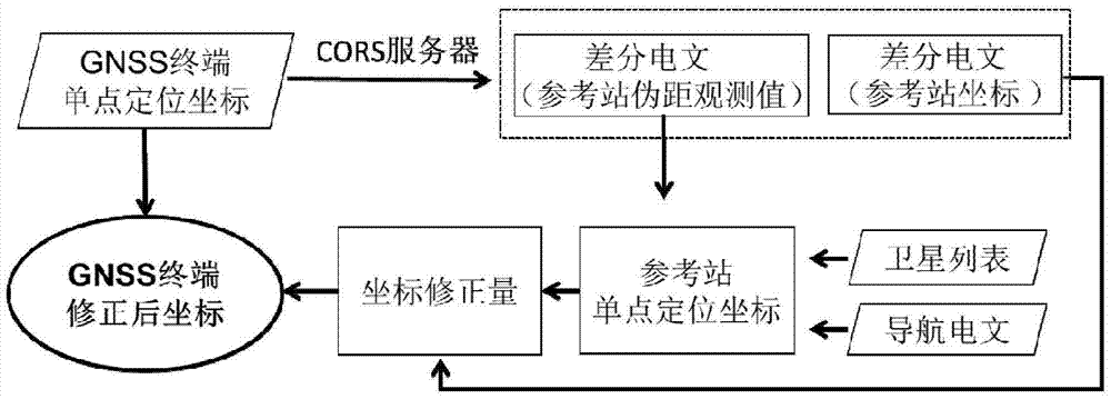
[0025] please see figure 2 , a CORS-based GNSS single-point positioning coordinate correction method provided in this embodiment includes the following steps:

[0026] Step 1: The GNSS terminal uses the received pseudo-range observations to perform single-point positioning and obtain the approximate coordinates at time t Will Send to the CORS server via the Internet;

[0027] Step 2: The CORS server sends a differential message to the GNSS terminal through the Internet, which contains the following information: reference station coordinates Pseudorange observations at the reference station at time t;

[0028] Step 3: Obtain according to GNSS terminal Select the corresponding pseudo-range observation value from the differential message, combine the navigation message obtained by the GNSS terminal to perform single-point positioning, and obtain the single-point positioning coordinates of the reference station at time t The acquisition of the navigation message here ca...

Embodiment 2

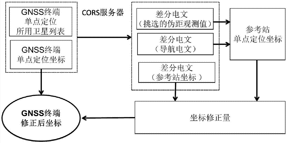
[0034] please see image 3 , a kind of CORS-based GNSS single-point positioning coordinate correction method provided by the present embodiment, is characterized in that, comprises the following steps:

[0035] Step 1: The GNSS terminal uses the received pseudo-range observations to perform single-point positioning and obtain the approximate coordinates at time t Will and the satellite list Γ used at time t is sent to the CORS server through the Internet;

[0036] Step 2: The CORS server sends a differential message to the GNSS terminal through the Internet, which contains the following information: reference station coordinates Navigation messages and pseudo-range observations of satellites listed in Γ;

[0037] Step 3: According to Γ, select the corresponding pseudo-range observation value from the differential message for single-point positioning, and obtain the single-point positioning coordinates of the reference station at time t

[0038] Step 4: Calculate the coo...


PUM


Abstract

The invention discloses a GNSS point positioning coordinate correction method based on CORS. A CORS system acquires coordinates of a reference station and observation values, and a coordinate correction value is calculated based on the initial outline coordinates obtained by a GNSS terminal in a point positioning manner and a satellite list used during the positioning; and the coordinate correction value is applied to the outline coordinates and precision approximate to the pseudo range difference can be obtained. The original observation values of the GNSS terminal are not needed, and the problem of inconsistent signs of conventional coordinate difference technology is solved, so that the application prospect is wide.

Description

technical field [0001] The invention belongs to the technical field of surveying and mapping geographic information, and in particular relates to a CORS (Continuously Operating Reference Station System)-based GNSS single-point positioning coordinate correction method, which can improve single-point positioning accuracy without relying on original observation values ​​of GNSS terminals. Background technique [0002] GNSS (Global Satellite Navigation System) is a general term for various satellite positioning systems such as GPS, GLONASS, and BDS, and is currently widely used in various fields of national economic construction. At any position on the earth, as long as the signals of more than 4 satellites can be received at the same time, the coordinates of the GNSS terminal can be determined according to the principle of space distance rendezvous. Due to the existence of satellite orbit error, ionospheric delay, tropospheric delay, pseudo-range noise and other errors, the acc...

Claims


Application Information

Patent Timeline
Patent Type & Authority Applications(China)
IPC IPC(8): G01S19/41
CPCG01S19/41
Inventor 章迪郭际明陈明史俊波李昕周吕王高靖
Owner WUHAN UNIV
Learn More