
Multi-scale space-time hot point path detection method based on rapid road network modeling

A technology of hotspot paths and detection methods, which is applied to road network navigators and other directions

Active Publication Date: 2016-01-20
SHENYANG INST OF AUTOMATION - CHINESE ACAD OF SCI
View PDF2 Cites 31 Cited by
  • Summary
  • Abstract
  • Description
  • Claims
  • Application Information

AI Technical Summary

Problems solved by technology

The clustering direction of trajectory clustering diverges in any direction and is unlimited; while the detection direction of hotspot path detection can only be along the direction of the road, which is limited

Method used


Image

  • Multi-scale space-time hot point path detection method based on rapid road network modeling
  • Multi-scale space-time hot point path detection method based on rapid road network modeling
  • Multi-scale space-time hot point path detection method based on rapid road network modeling

Examples


Embodiment Construction

[0058] The present invention will be further described in detail below in conjunction with the accompanying drawings and examples.

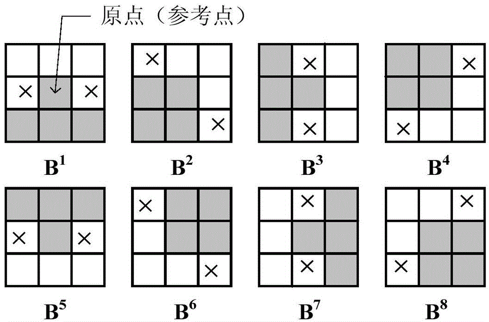
[0059] The invention relates to a global hotspot path detection method based on large-scale spatio-temporal trajectory data, including: based on the historical trajectory data of moving objects in the city, using a morphological method to quickly construct a road network structure represented by a grid; performing road matching on the trajectory, Convert the track point sequence into a "road grid" sequence; divide the time domain into small-scale time periods, and count the trajectory amount of the "road grid" in each period, that is, the flow; define the "road grid" according to the grid flow According to the traffic reachability condition, hotspot path starting condition, and path traffic reachability condition, the road network structure is transformed into a graph structure according to the flow reachability definition, and the graph is transf...


PUM


Abstract

The present invention relates to a multi-scale space-time hot point path detection method based on rapid road network modeling. The multi-scale space-time hot point path detection method comprises: constructing a road network by using large-scale track data; based on the constructed road network, carrying out road matching on the track; converting the track point sequence into the grid sequence covering the road; and carrying out hot point detection. According to the present invention, the multi-scale space-time hot point path detection method under the road-network-free topology support is provided so as to achieve the rapid road network construction based on the large-scale track data and the effective detection on the high flow path in the road network; and the high precision road network topology support is not required, the particular type of the data is not required, the positioning data of any existing positioning equipment can be used, and advantages of low economic input, rapidness, high efficiency and the like are provided.

Description

technical field [0001] The invention relates to the technical field of hotspot path search in road networks, and is a method for quickly constructing a road network and then detecting hotspot paths by using large-scale spatio-temporal trajectory data without the support of a road network map. Background technique [0002] A hotspot path can be defined as a road section frequently passed by a large number of moving objects in a period of time. It can reflect the degree of attention or dependence of people on a certain geographical area during the movement process, and can also reveal the law of people's movement to a certain extent. Hotspot path detection can be used for decision support in urban planning, traffic management, advertising and other fields. [0003] Different from the hot path concept in Patent Document 1 (Patent Publication No. CN103323018A), the hot path refers to the most commonly used path among all paths from the source point to the destination point, whic...

Claims


Application Information

Patent Timeline
IPC IPC(8): G01C21/34
Inventor 吕赐兴朱云龙张丁一库涛陈瀚宁吴俊伟
Owner SHENYANG INST OF AUTOMATION - CHINESE ACAD OF SCI
Learn More