
Method for converting microwave remote sensing surface temperature to thermal infrared remote sensing land surface temperature

A technology for thermal infrared remote sensing and surface temperature, applied in the field of remote sensing applications

Active Publication Date: 2015-12-30
UNIV OF ELECTRONIC SCI & TECH OF CHINA
View PDF4 Cites 11 Cited by
  • Summary
  • Abstract
  • Description
  • Claims
  • Application Information

AI Technical Summary

Problems solved by technology

[0004] However, there is a major problem in the application of passive microwave in retrieval of surface temperature: compared with thermal infrared remote sensing, passive microwave has stronger penetrating ability and can carry radiation information from deeper below the surface
[0005] At present, considering the factor of thermal sampling depth, there are relatively few studies on estimating land surface temperature from passive microwave remote sensing data

Method used


Image

  • Method for converting microwave remote sensing surface temperature to thermal infrared remote sensing land surface temperature
  • Method for converting microwave remote sensing surface temperature to thermal infrared remote sensing land surface temperature
  • Method for converting microwave remote sensing surface temperature to thermal infrared remote sensing land surface temperature

Examples


Embodiment Construction

[0042] The technical solution of the present invention will be described in detail below in combination with the embodiments and the accompanying drawings.

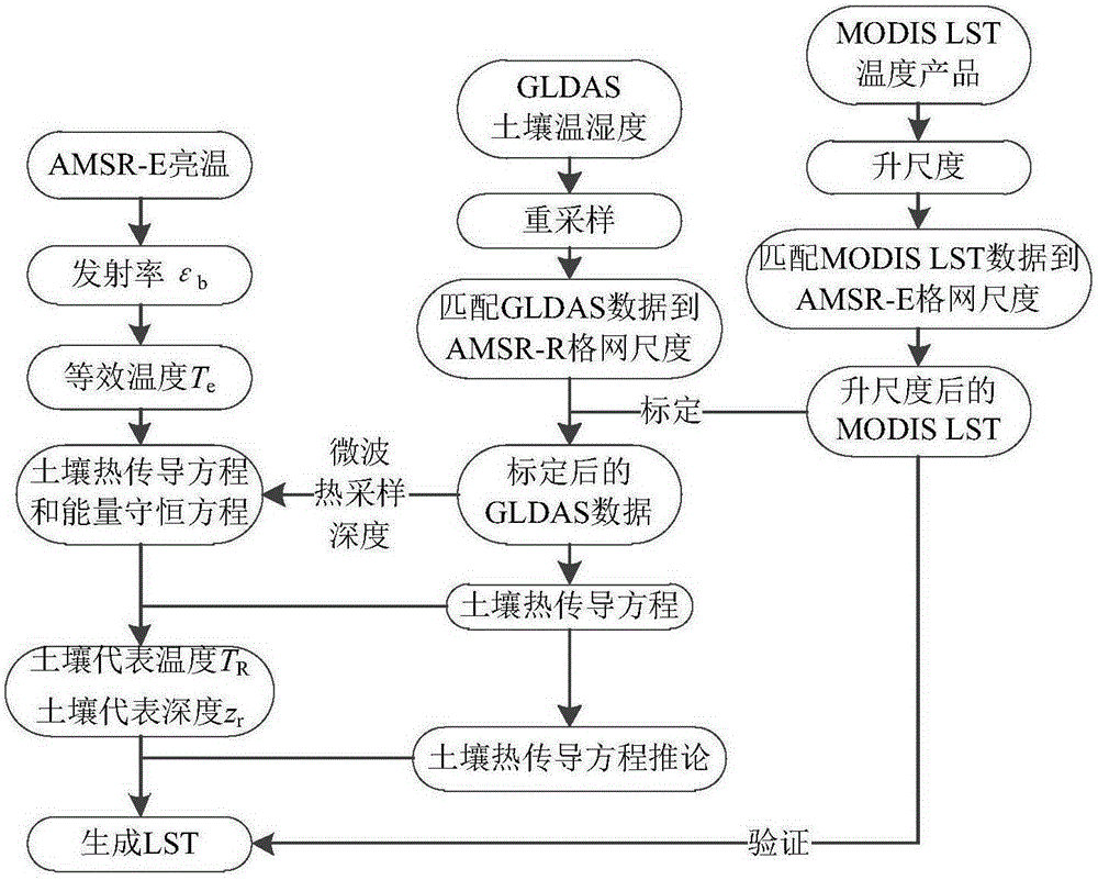
[0043] Two typical regions were selected, namely northwest China and parts of Mongolia (98°E~103°E, 39°N~44.5°N), and western Namibia (14.5°E~16°E, 21°S~ 24°S). It is characterized in that the underlying surface is dominated by bare soil. At the same time, the climate of the two regions is arid, and the temperature difference between day and night is large. The microwave thermal sampling temperature difference is obvious, which can fully highlight the difference between the microwave surface temperature and the surface temperature. The processing flow of the present invention is as figure 1 shown.

[0044] The data sets used in this embodiment include: AMSR-E brightness temperature, MODIS surface temperature products, and GLDAS global land surface soil temperature and humidity data. It is characterized in that AMSR-E d...


PUM


Abstract

The invention belongs to the technical field of remote sensing application, and particularly relates to a method for converting microwave remote sensing surface temperature to thermal infrared remote sensing land surface temperature. A physical method suitable for a bare-ground area is provided based on a soil heat conduction equation. The method comprises the steps of data preprocessing; GLDAS data calibration; equivalent temperature generation; conversion from microwave remote sensing surface temperature to thermal infrared remote sensing land surface temperature, wherein land surface temperature which has the same physical significance as thermal infrared remote sensing land surface temperature is generated through passive microwave remote sensing data. The method can be universally applied to existing passive microwave remote sensing inversion land surface temperature algorithms. By the adoption of the method, the precision of the algorithms in inversion of bare-ground area surface temperature is improved.

Description

technical field [0001] The invention belongs to the technical field of remote sensing applications, in particular to a method for converting microwave remote sensing surface temperature to thermal infrared remote sensing skin surface temperature. Background technique [0002] As a key parameter at the interface between the land surface and the atmosphere, surface temperature is an indicator of global and regional climate change. The acquisition of large-scale surface temperature is a key link in the research of energy conversion between the earth and the atmosphere and monitoring of terrestrial ecosystems. Therefore, timely and accurate acquisition of surface temperature is of great significance for the study of global climate change and ecological environment change. [0003] Algorithms for retrieving land surface temperature from thermal infrared remote sensing data have been very mature, which has effectively promoted the study of various land surface processes and playe...

Claims


Application Information

Patent Timeline
IPC IPC(8): G01S13/95G01S7/02
CPCG01S7/02G01S13/95Y02A90/10
Inventor 周纪张晓东马晋代冯楠
Owner UNIV OF ELECTRONIC SCI & TECH OF CHINA
Learn More