Sunshine duration calculation based on ground feature TIN model

A technology of sunshine and hours, which is applied in the field of calculation of sunshine hours based on the ground object TIN model, can solve the problems affecting the calculation of the shadow range of ground objects and the large error in the calculation of sunshine hours, so as to reduce errors, improve calculation methods, and improve The effect of computational precision

Inactive Publication Date: 2015-12-02
NORTH CHINA UNIV OF WATER RESOURCES & ELECTRIC POWER
View PDF5 Cites 7 Cited by
  • Summary
  • Abstract
  • Description
  • Claims
  • Application Information

AI Technical Summary

Problems solved by technology

[0003] On the contrary, the difference in latitude and longitude coordinates between ground features will appear in the calculation of elevation angle and azimuth angle, which will affect the calculation of shadow range of ground features, and eventually lead to large errors in the calculation of sunshine hours

Method used


Image

  • Sunshine duration calculation based on ground feature TIN model
  • Sunshine duration calculation based on ground feature TIN model
  • Sunshine duration calculation based on ground feature TIN model

Examples


Embodiment Construction

[0022] The present invention will be described in further detail below in conjunction with the accompanying drawings and specific embodiments.

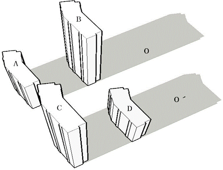
[0023] Because complex geographic scenes include features such as buildings, terrain, vegetation, and landmarks, choosing the TIN data model to express feature data can not only effectively achieve the fusion and conversion of multi-source data, but also simplify feature projection and test points. Judgment process of topological relationship.

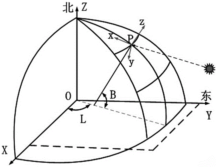
[0024] The present invention uses an astronomical algorithm, that is, a method published in "Astronomical Algorithms" (Meeus, 1998) (a representative algorithm of TEP-SPA) as the SPA algorithm for calculating the sun's position.

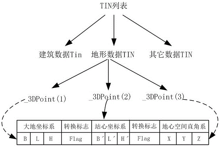
[0025] like figure 1 As shown, in the present invention, buildings, landforms and other ground object types are uniformly expressed by TIN structure, and a single TIN is composed of disordered three points (_3DPoint self-defined structure). In order to avoid ignori...


PUM


Abstract

The invention provides sunshine duration calculation based on a ground feature TIN model. The sunshine duration calculation comprises the following steps: a data structure of a ground feature TIN model is established, an internal storage structure of a single point in the data structure comprises a ground coordinate system, a topocentric coordinate system and a space rectangular coordinate system, and the conversion sign of the coordinate systems is Flag; all-day sunshine duration is calculated, the all-day sunshine duration is dispersed according to a set step and a dispersed time sequence is formed; the solar altitude and azimuth of a certain time point in the time sequence are calculated, then ground feature data in a ground feature TIN list is cycled, a projection formed by a certain point in the model on a shadow receiving altitude plane, whether a point needing calculation of sunshine duration is shielded is determined, and once shielding is formed, cycle exit is performed; finally, accumulation of shielding time of the points needing calculation sunshine duration is carried out, and the sunshine duration period is calculated. Errors caused by longitude and latitude coordinates are reduced, a calculation method for sunshine duration is improved, and the calculation precision of sunshine duration is raised greatly.

Description

technical field [0001] The invention relates to the calculation of daily hours of complex terrain, in particular to a calculation of sunshine hours based on a ground object TIN model. Background technique [0002] The shape of the earth and the spatial position of the occluded and occluded objects have an important impact on the sunshine hours, but in the traditional analysis of building sunshine, the entire analysis area is regarded as an ideal plane under the same longitude and latitude, not only ignoring the shape of the earth features, and also ignores the difference between the longitude and latitude coordinates of the occluded and occluded features. According to the theory of "Ellipsoid Geodesy", when the earth's surface distance is greater than 10 kilometers, the calculation of the normal intercept line must consider the shape characteristics of the earth. Taking Nanjing (East Longitude 118°48′, North Latitude 32°04′) as an example, at 7:30 am on December 21, 2008 (W...

Claims


Application Information

Patent Timeline
Patent Type & Authority Applications(China)
IPC IPC(8): G01W1/12G06F19/00
Inventor 张富毛大鹏张丽娟邱本志
Owner NORTH CHINA UNIV OF WATER RESOURCES & ELECTRIC POWER
Why Eureka
Try Eureka