Software receiver-based distributed deep integrated navigation method and system

A software receiver and deep integrated navigation technology, which is applied in the field of satellite navigation, can solve the problems of poor dynamic tracking performance of the receiver, large tracking error of the GNSS receiver, and low positioning accuracy, so as to suppress the influence of noise and multipath effect, The effect of improving dynamic tracking performance and reducing tracking error

Inactive Publication Date: 2015-09-23
NANJING UNIV OF SCI & TECH
View PDF4 Cites 8 Cited by
  • Summary
  • Abstract
  • Description
  • Claims
  • Application Information

AI Technical Summary

Problems solved by technology

However, in the current distributed deep combination, even if the tracking loop of the GNSS receiver is assisted, the frequency drift of the receiver clock cannot be estimated more accurately, and the dynamic stress and carrier effects of high dynamics on the tracking loop cannot be completely eliminated. Due to the frequency offset caused by mechanical vibration, clock drift, etc., the tracking error of the GNSS receiver is still large, resulting in poor dynamic tracking performance of the GNSS receiver; at the same time, due to the influence of GNSS r

Method used


Image

  • Software receiver-based distributed deep integrated navigation method and system
  • Software receiver-based distributed deep integrated navigation method and system
  • Software receiver-based distributed deep integrated navigation method and system

Examples


Embodiment Construction

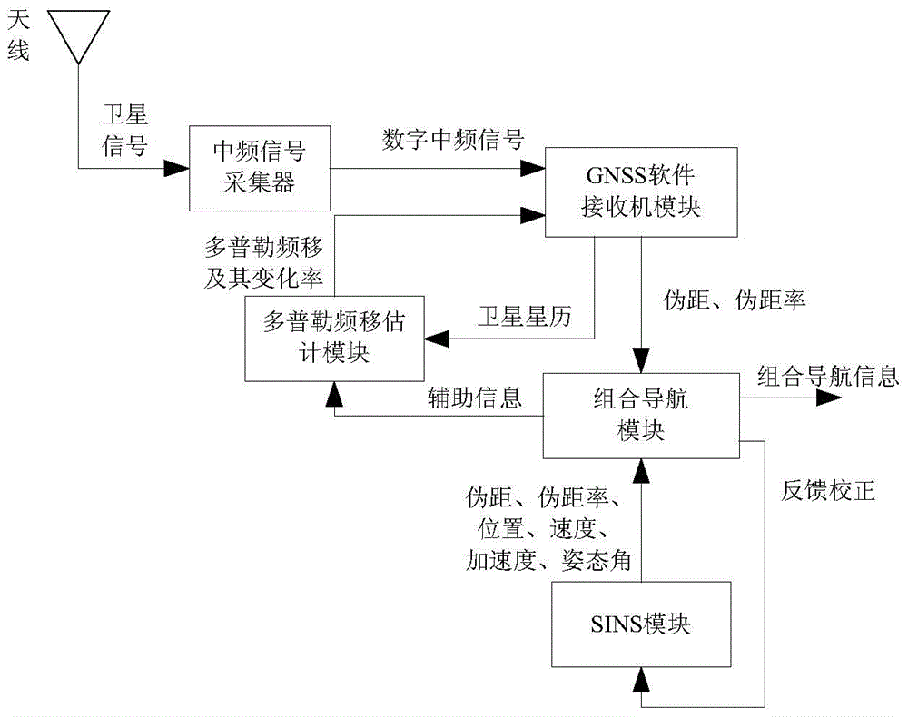
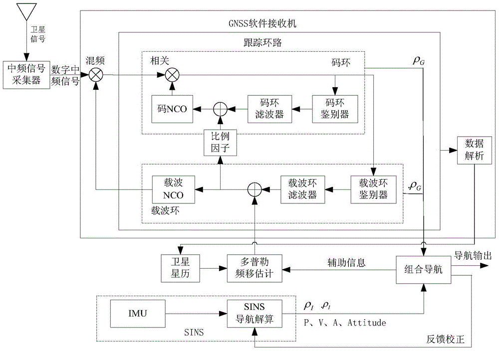
[0017] The distributed deep integrated navigation system of the present invention includes an intermediate frequency signal collector, a Doppler frequency shift estimation module, a SINS module, a GNSS software receiver module and an integrated navigation module.

[0018] 1. IF signal collector

[0019] The intermediate frequency signal collector performs down-conversion and digital processing on the received satellite signals, generates digital intermediate frequency signals and saves them as binary files, and provides them to the GNSS software receiver module for use.

[0020] 2. Doppler frequency shift estimation module

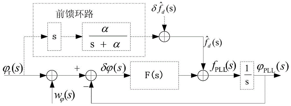
[0021] The Doppler frequency shift estimation module predicts and obtains the three-dimensional position, velocity and acceleration information of the carrier at the current moment according to the three-dimensional position, velocity and acceleration auxiliary information of the carrier provided by the integrated navigation module at the previous moment; ...


PUM


Abstract

The invention provides a software receiver-based distributed deep integrated navigation method and system. According to the software receiver-based distributed deep integrated navigation method and system, a GNSS software receiver adopts Doppler frequency shift calculated by Doppler frequency shift estimation; an auxiliary receiver tracking loop performs carrier tracking and code tracking, and filters outputted GNSS pseudo-range and pseudo-range rate information and provides the filtered information to an integrated navigation module; a carrier tracking loop adjusts a carrier NCO according to the Doppler frequency shift and carrier frequency errors outputted by a carrier loop filter; a code tracking loop adjust a code NCO according to frequency provided by the carrier tracking loop and code frequency errors outputted by a code loop filter; and therefore, two-way assistance of a GNSS and an SINS can be realized. With the software receiver-based distributed deep integrated navigation method and system of the invention adopted, the influence of the dynamic condition of a carrier on the carrier tracking loop can be decreased, and the tracking errors of the GNSS receiver can be decreased under a high dynamic environment, and the dynamic tracking performance of the GNSS receiver under the high dynamic environment can be improved, and therefore, the navigation and positioning accuracy of the integrated navigation system can be further improved.

Description

technical field [0001] The invention belongs to the technical field of satellite navigation, and in particular relates to a software receiver-based distributed deep integrated navigation method and system. Background technique [0002] The integrated navigation system composed of the combination of Strap-down Inertial Navigation System (SINS) and Global Navigation Satellite System (GNSS) fully utilizes the advantages of GNSS positioning accuracy not changing with time and SINS completely autonomous navigation. Advantages, its overall performance is far superior to each independent system. The combination of SINS and GNSS can be roughly divided into three types, among which deep integrated navigation is the most advanced combination form at present. According to related literature at home and abroad, there are two main implementation forms of deep integrated navigation of SINS and GNSS: centralized deep combination based on deep combination filter proposed by Draper laborato...

Claims


Application Information

Patent Timeline
IPC IPC(8): G01S19/49G01C21/16
CPCG01S19/49G01C21/165
Inventor 陈帅刘亚玲丁翠玲余威董亮屈新芬黄思亮彭蜀军邓贵军陆帅
Owner NANJING UNIV OF SCI & TECH
Why Eureka
Try Eureka