A method and system for supervising highway signs

A marking and highway technology, applied in the field of computer information, can solve the problems of inconsistent standards, influence of travel instructions, and long detection cycle time, and achieve the effect of improving detection efficiency, ensuring driving safety, and shortening detection cycle.

Active Publication Date: 2017-08-25
HUNAN NORMAL UNIVERSITY
View PDF5 Cites 1 Cited by
  • Summary
  • Abstract
  • Description
  • Claims
  • Application Information

AI Technical Summary

Problems solved by technology

At present, the systems used for road supervision and maintenance mainly include road surface management system and bridge management system, etc., and these systems are only used to detect and maintain the geology and road surface, and cannot realize the supervision of road signs
[0003] Highway signs are usually set on both sides of the highway or on the top of the highway. When monitoring them, staff need to collect and input data on the spot along the way, which not only consumes a lot of manpower, material resources, time and resources, but is prone to missed inspections and missing records. , and because the detection cycle takes a long time, the damaged road signs will not be found and replaced in time, which will affect the specification, appearance and safety index of the road, and have a negative impact on people's travel instructions; in addition, due to human judgment Differences can easily lead to problems such as inconsistent standards
It is self-evident that the integrity of the road signs on the expressway is important to the safe driving of drivers. For example, the lack of road signs on the expressway can easily lead to serious traffic accidents such as speeding of high-speed vehicles; The long distance of the road and the excessive speed of the vehicle will also affect the working efficiency of the staff, and more importantly, it will also endanger the safety of the staff

Method used


Image

  • A method and system for supervising highway signs
  • A method and system for supervising highway signs
  • A method and system for supervising highway signs

Examples


Embodiment Construction

[0069] The present invention will be further described in detail below in conjunction with the accompanying drawings and specific embodiments.

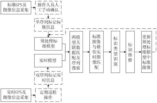
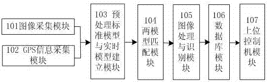
[0070] A supervision system for highway signs, its structural block diagram is as follows figure 2 As shown, it includes an image acquisition module 101, a GPS information acquisition module 102, a preprocessing standard model and real-time model building module 103, a two-model matching module 104, an image processing and recognition module 105, a database module 106 and a host computer control module 107. The functions of each module and the transmission of information between modules are as follows.

[0071] The image collection module 101 is configured to collect images of road signs. The image collection module 101 includes two parts: one is to collect and store standard images of fixed-point road signs through the vehicle-mounted industrial camera, and the other is to collect real-time images of road signs during the traveling...


PUM


Abstract

A method and system for supervising highway signs, the method includes: firstly, establishing a preprocessing standard model by labeling a single sequence from existing highway standard GPS and image data; secondly, obtaining the latest real-time GPS and Image data, establish a real-time model by annotating double sequences; then, compare the real-time model data with the standard model data through double-sequence matching search, and match the real-time best image obtained from the real-time model with the standard image in the standard model. ; Further, use the image matching algorithm to compare the standard model image data to determine the specific type of identification damage; finally, update the standard model according to the identification result and maintenance status. According to the internal relationship between the position of the road sign and the image, the invention periodically collects, automatically identifies and locates the damage of the road sign and its type, thereby improving the detection efficiency of road assets and reducing the maintenance workload.

Description

technical field [0001] The invention relates to the field of computer information technology, in particular to a method and a system for supervising road signs by using an information system. Background technique [0002] As one of the basic constructions, roads are an important part of public assets. After road construction is completed, real-time supervision and maintenance are required to ensure the normal use of roads. At the same time, real-time supervision and maintenance are also one of the most basic means to protect road assets. At present, the systems used for road supervision and maintenance mainly include pavement management system and bridge management system, etc., and these systems are only used to detect and maintain the geology and road surface, and cannot realize the supervision of road signs. [0003] Highway signs are usually set on both sides of the highway or on the top of the highway. When monitoring them, staff need to collect and input data on the sp...

Claims


Application Information

Patent Timeline
Patent Type & Authority Patents(China)
IPC IPC(8): G06K9/54G06K9/62G06Q50/26
Inventor 彭可谢琴邵添郭启明阳领冯准王世杰李仲阳
Owner HUNAN NORMAL UNIVERSITY
Why Eureka
Try Eureka