A kind of bus gps positioning system and method thereof

A technology of GPS positioning and positioning method, which is applied in the direction of satellite radio beacon positioning system, radio wave measurement system, instrument, etc., and can solve the problem of large deviation in the ideal situation of the application terminal display module, the position of the bus cannot be reached, the bus is not on the road, etc. problem, to achieve the effect of reducing the difficulty of getting started, showing a simple and beautiful display, and displaying a clear and easy-to-understand effect

Active Publication Date: 2018-11-13
贵州智通天下信息技术有限公司
View PDF6 Cites 0 Cited by
  • Summary
  • Abstract
  • Description
  • Claims
  • Application Information

AI Technical Summary

Problems solved by technology

However, the GPS data is not accurate enough. The deviation of civilian GPS data is generally 100 meters, at least up to 10 meters. For a specific application that can display the location of the bus on Baidu map / Gaode map in real time, it is necessary to use GPS The position is corrected to prevent the user from having the illusion that the bus is not running on the bus line correctly
[0003] Specifically, as figure 1 As shown, in the prior art, the application terminal display module directly reads and displays information from the map database, the bus route database, and the bus GPS device. However, the bus route is not always a simple line segment. In practice, the bus route may have various There may even be four stations on opposite sides of a building, and the bus may deviate from the scheduled bus route due to reasons such as refueling and traffic jams during the actual driving process, which makes the application terminal display The deviation between the actual situation displayed by the module and the ideal situation is very large, and such a deviation will undoubtedly make the user feel very confused, and then produce the feeling that it is better not to perform GPS positioning, that is, the disadvantages of the existing technology are:
[0004] 1. Since the bus line is formed by the pre-stored data connection, the position of the bus on the map cannot be displayed on the bus line;
[0005] 2. Due to the error of the GPS data itself, the position of the bus on the map may not be on the road;
[0006] 3. Unable to judge the direction of the bus, so that the correct bus line that should be displayed cannot be selected, causing users to feel bad, and mistakenly believe that the application software cannot correctly display the bus location;

Method used


Image

  • A kind of bus gps positioning system and method thereof
  • A kind of bus gps positioning system and method thereof
  • A kind of bus gps positioning system and method thereof

Examples


Embodiment Construction

[0042] The technical solution of the present invention is further described below, but the scope of protection is not limited to the description.

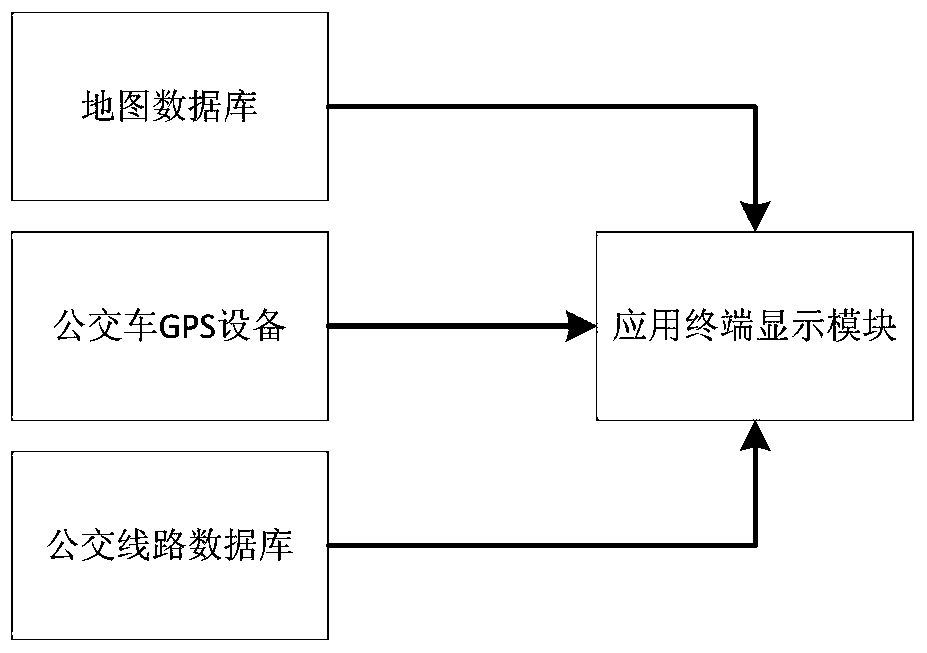
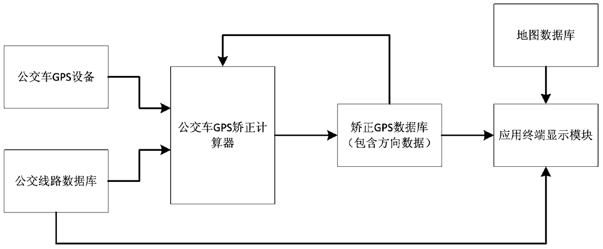
[0043] Such as figure 2 A bus GPS positioning system is shown, the bus is provided with a bus GPS device, there is a bus route database locally, the bus route database is connected to the bus GPS correction calculator, and the bus GPS device is connected to the bus The car GPS correction calculator and bus GPS correction calculator are set on the local or application terminal; there is a correction GPS database locally, and the bus GPS correction calculator communicates with the correction GPS database; the network or local map database and the local The corrected GPS database is connected in parallel with the display module of the application terminal.

[0044] The corrected GPS database stores the corrected GPS position data, and provides it as a data source to the display module for position display.

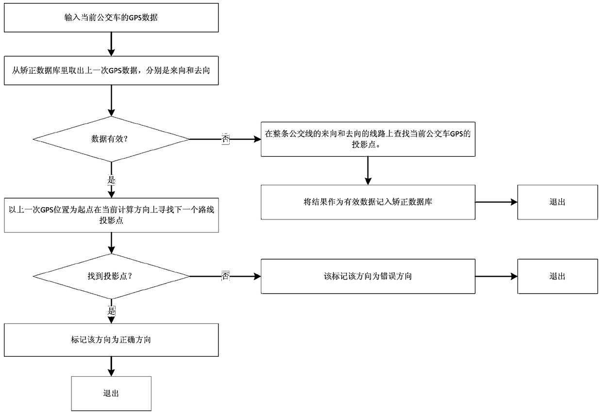
[0045] The correction c...


PUM


Abstract

The invention provides a bus GPS (global positioning system) and a positioning method thereof. The bus GPS is characterized in that a bus is provided with bus GPS equipment, a bus line database is arranged locally and is in communicated connection with a bus GPS correcting calculator which is arranged locally or an application terminal, and the bus GPS equipment is connected to the bus GPS correcting calculator in a communication manner. A correcting GPS database is arranged locally, the bus GPS correcting calculator is connected to the correcting GPS database in a communication manner, and a network or local map database and the local correcting GPS database are parallel to be in communicated connection with an application terminal display module. The bus GPS and the positioning method thereof are capable of correcting bus GPS position data and describing bus positions accurately so as to provide optimal usage feeling for a user.

Description

technical field [0001] The invention relates to a bus GPS positioning system and a method thereof, belonging to the bus positioning technology. Background technique [0002] GPS positioning system is widely used in various transportation equipment, bus is only one example. Install GPS equipment on the bus to obtain its own GPS location information in real time, and send it to the background data center to complete the acquisition process of GPS positioning data. However, the GPS data is not accurate enough. The deviation of civilian GPS data is generally 100 meters, at least up to 10 meters. For a specific application that can display the location of the bus on Baidu map / Gaode map in real time, it is necessary to use GPS The position is corrected to prevent users from having the illusion that the bus is not running on the bus line correctly. [0003] Specifically, as figure 1 As shown, in the prior art, the application terminal display module directly reads and displays i...

Claims


Application Information

Patent Timeline
Patent Type & Authority Patents(China)
IPC IPC(8): G01S19/42
CPCG01S19/42
Inventor 游明琦牟俊杨才皓
Owner 贵州智通天下信息技术有限公司
Why Eureka
Try Eureka