
Method for automatically identifying seabed sand wave features based on ODP

An automatic identification and multi-beam technology, applied in special data processing applications, instruments, electrical digital data processing, etc., can solve the problems of limitations and low recognition rate

Active Publication Date: 2014-09-24
SECOND INST OF OCEANOGRAPHY MNR
View PDF3 Cites 3 Cited by
  • Summary
  • Abstract
  • Description
  • Claims
  • Application Information

AI Technical Summary

Problems solved by technology

[0006] Aiming at the limitations of existing terrain recognition methods that rely heavily on threshold selection and the low recognition rate, the present invention discloses an automatic recognition method for seabed sand wave features based on ODP, specifically a grid-based seabed sand wave feature identification method. Optimally-Directional Profiling method (ODP, Optimally-Directional Profiling method) of wave characteristic lines: Firstly, based on the optimal profile direction of the water depth surface, the derivative is determined and the extremum is determined, so as to extract the feature points of the seabed sand wave ridges and valleys

Method used


Image

  • Method for automatically identifying seabed sand wave features based on ODP
  • Method for automatically identifying seabed sand wave features based on ODP
  • Method for automatically identifying seabed sand wave features based on ODP

Examples


Embodiment 1

[0070] A method for automatic identification of seabed sand wave features based on ODP, comprising the following steps:

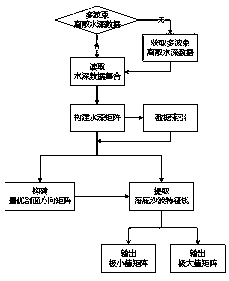
[0071] The schematic flow chart of the present invention is shown in figure 1 .

[0072] Step 1) Mapping digital water depth matrix

[0073] 1.1) Construct water depth matrix

[0074] 1.1.1) If there is no multi-beam discrete water depth data, use the full coverage measurement method to obtain multi-beam water depth data, obtain the multi-beam discrete data set MBES after data editing and correction processing, and enter step 1.1.2);

[0075] 1.1.2) If the multi-beam discrete water depth data set MBES, use the inverse distance weighting method to construct the water depth matrix Among them, G(i, j) is the water depth matrix point in row i and column j, nx is the total number of rows in the matrix, ny is the total number of columns in the matrix, and i, j, nx, and ny are all natural numbers;

[0076] 1.2) Construct data index of water depth matrix

[0...

Embodiment 2

[0122] In order to verify the effectiveness and correctness of "a kind of automatic recognition method for seabed sand wave characteristics based on ODP", the technical process in Example 1 is used to select a representative sand wave area for experiments. The specific process:

[0123] 1) Surveying and mapping digital water depth matrix: In the experiment, the sand wave data measured by the multi-beam bathymetry system is used to test the method. The high-precision water depth data adopts the R2Sonic2024 ultra-high resolution multi-beam sounding system. After data editing and correction processing, the multi-beam discrete data set is obtained, and the distance inverse weighting method is used to construct the water depth matrix in the sand wave area. Figure 4 ;

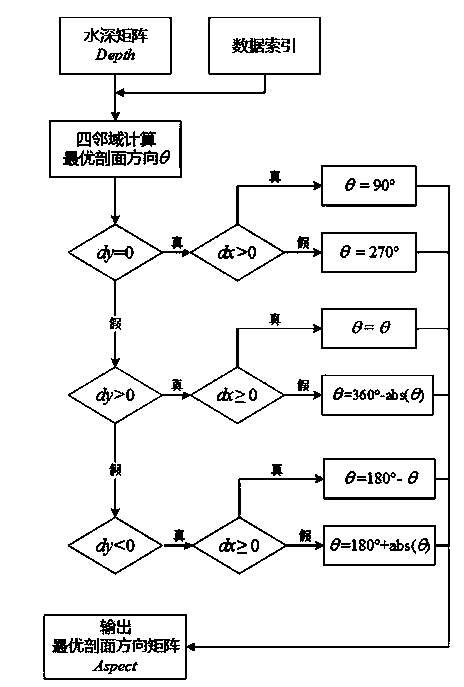
[0124] 2) Construct the optimal profile direction matrix: according to figure 2 In the steps shown, the optimal section direction matrix of the constructed sand wave area is Figure 5 ;

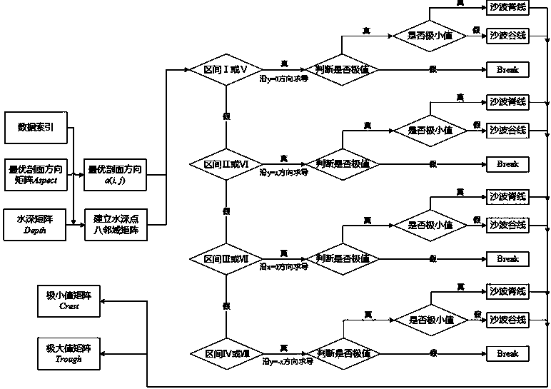
[0125] 3) Extract the c...

Embodiment 3

[0129] In order to further verify the effectiveness and correctness of "an automatic identification method for seabed sand wave characteristics based on ODP", the hydrological analysis method and the slope aspect variability analysis method were used to carry out comparative experiments on the same sand wave area in Example 2, and the statistics Under different classification threshold conditions, the hydrological analysis method and slope aspect variability analysis method extract the number of feature points in the sand wave area and the correlation coefficient with the manual identification feature line:

[0130] 1) The hydrological analysis method extracts the number of characteristic points of ridges and valleys in the sand wave area, and the correlation coefficient with the characteristic lines of manual identification is as follows: Figure 7 , where the maximum correlation coefficients between the ridgeline and valleyline in the sand wave area extracted by the hydrologi...


PUM


Abstract

The invention discloses a method for automatically identifying seabed sand wave features based on an ODP. By means of the method, feature points of ridge lines and valley lines of seabed sand waves are extracted by means of an extreme value derived and judged according to the optimal profile direction of a water depth curve, and used for automatic identification and extraction of a seabed sand wave feature line. By means of the steps of (1) constructing a digital water depth matrix, (2) constructing an optimal direction matrix and (3) extracting the seabed sand wave features, automatic identification of the seabed sand waves is achieved. The method is verified by a multi-beam water depth data test in an actual measurement mode, the correlation coefficient of the seabed sand wave feature automatically identified by the method and the feature line identified by workers is higher than 80 percent, and compared with the traditional method, and the accuracy rate of automatic identification is increased by 30 percent averagely. Furthermore, no setting of a threshold value is needed, so that working efficiency is increased greatly. The method can be applied to automatic identification of other types of submarine topography and land topography, and has important practical application value in aspects of hydrographic surveying and charting, marine geographic information systems, computer graphics, seabed scientific researches and the like.

Description

technical field [0001] The invention relates to the technical fields of seabed topography and landform mapping, ocean surveying and mapping, ocean geographic information system, computer graphics and seabed science. Background technique [0002] Submarine sand wave is a very common marine landform developed on the offshore shelf. The migration and movement of sand wave can characterize the characteristics of the marine sedimentary environment, and may also affect or even hinder human activities, such as the possibility of hollowing out or burying laid submarine pipelines , silting and shallowing the channel port, causing the structure foundation of the wind farm to be unstable, etc., which can cause serious submarine disasters. Therefore, the study of seabed sand waves provides powerful information and support for understanding shallow sea sediment transport and rationally designing and planning ocean engineering. Sand waves have a wave-like shape, and the crests and trough...

Claims


Application Information

Patent Timeline
Patent Type & Authority Applications(China)
IPC IPC(8): G06F19/00
Inventor 吴自银周洁琼赵荻能李守军尚继宏梁裕扬周勐佳
Owner SECOND INST OF OCEANOGRAPHY MNR
Learn More