InSAR atmosphere delay correction method based on GPS

An atmospheric delay and algorithm technology, applied in the field of large-scale, GPS, microwave remote sensing technology fusion, high-precision, multi-temporal surface deformation monitoring, can solve problems affecting deformation monitoring accuracy, achieve high-precision correction, improve accuracy and efficiency , the effect of improving the accuracy

Inactive Publication Date: 2014-06-25
HENNAN ELECTRIC POWER SURVEY & DESIGN INST
View PDF3 Cites 13 Cited by
  • Summary
  • Abstract
  • Description
  • Claims
  • Application Information

AI Technical Summary

Problems solved by technology

[0006] The technical problem to be solved by the present invention is: for the existence of InSAR atmospheric delay, which seriously affects the accuracy of its deformation monitoring, the interpolation algorithm is used to calculate the GPS atmospheric delay to realize the correction of InSAR atmospheric delay

Method used


Image

  • InSAR atmosphere delay correction method based on GPS
  • InSAR atmosphere delay correction method based on GPS
  • InSAR atmosphere delay correction method based on GPS

Examples


Embodiment Construction

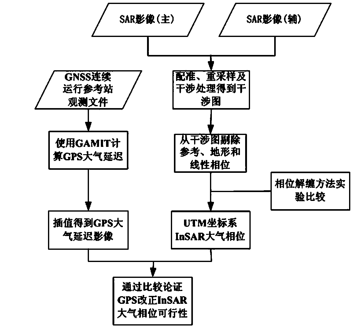
[0025] The concrete process of the present invention is described in detail with reference to accompanying drawing, comprises the following steps:

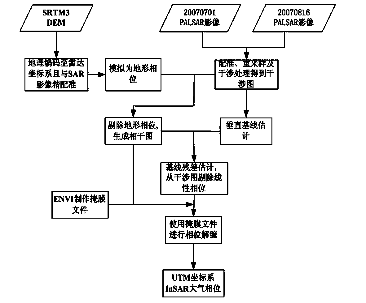
[0026] 1) SAR image processing

[0027] Use GAMMA software to perform interference processing on two SAR images in the same area, as shown in the attached figure 1 The shown includes image registration, resampling, interferometric processing, reference ellipsoid phase, terrain phase and linear phase from the interferogram, and finally an interferogram including only the InSAR atmospheric phase, as shown in the attached figure 2 shown.

[0028] 2) Evaluation of InSAR phase unwrapping accuracy

[0029] Using Visual C++ and MATLAB language and software, six methods including branch-cut method, quality-guided path tracking, unweighted least squares, weighted least squares, minimum discontinuity and minimum cost flow are used to phase the SAR interferometric image in the selected area Unwrapping, use the formula (1) to compare and ...


PUM


Abstract

The invention discloses an InSAR atmosphere delay correction method based on the GPS. The method comprises steps that: firstly, InSAR phase unwrapping method precision is optimized, and InSAR atmosphere delay phase in the UTM coordinate is extracted; secondly, a zenithal atmosphere delay value of a GPS continuous operation reference station is acquired, and interpolation is carried out by utilizing a PSO-LSSVM algorithm to acquire a GPS atmosphere delay image; and lastly, correction on InSAR atmosphere delay is carried out according to the result, and InSAR technology precision is greatly improved.

Description

technical field [0001] The invention belongs to the fusion field of GPS and microwave remote sensing technology, and specifically relates to a method for correcting the atmospheric delay of InSAR technology by utilizing the high-precision space water vapor model of GPS, and is mainly applied in the field of large-scale, high-precision, multi-temporal surface deformation monitoring. Background technique [0002] After more than 20 years of research, InSAR and D-InSAR technology have achieved fruitful results, and have been widely studied and applied in many fields, such as topographic survey, earthquake, landslide, volcano, large-scale surface subsidence, ocean mapping and disaster monitoring etc. However, there are still a series of problems such as time de-correlation and baseline de-correlation, atmospheric effects, phase unwrapping, etc., which greatly limit its application in actual production. [0003] The SAR satellite signal is affected by the atmosphere when passing...

Claims


Application Information

Patent Timeline
IPC IPC(8): G01S7/40G01S13/90
CPCG01B21/32G01S13/904G01S13/9023
Inventor 剧成宇王宇孙建勇张中原王绍宏高晓东乔石铭
Owner HENNAN ELECTRIC POWER SURVEY & DESIGN INST
Why Eureka
Try Eureka