Method for calibrating tidal flat DEM (digital elevation model) on basis of remote sensing water lines

A water edge and tidal flat technology, applied in special data processing applications, instruments, electrical digital data processing, etc., can solve problems such as uncontrollable accuracy, poor timeliness, difficult measurement, etc., to achieve simple and feasible technology, convenient operation, and solution acquisition difficult effect

Inactive Publication Date: 2014-04-30
HOHAI UNIV
View PDF3 Cites 8 Cited by
  • Summary
  • Abstract
  • Description
  • Claims
  • Application Information

AI Technical Summary

Problems solved by technology

[0012] The technical problem to be solved by the present invention is to provide a tidal flat DEM calibration method based on remote sensing water edge, which overcomes the problems of measurement difficulty, poor timeliness and uncontrollable precision in the existing DEM construction method, and realizes it through continuous correction of DEM. The complete agreement between the hydrodynamic model and the remote sensing water edge improves the accuracy of DEM construction, and this method can obtain the latest topographic data (DEM) that can best reflect the current status of the tidal flat based on the old terrain through the correction of the water edge. Meet the needs of real-time monitoring

Method used


Image

  • Method for calibrating tidal flat DEM (digital elevation model) on basis of remote sensing water lines
  • Method for calibrating tidal flat DEM (digital elevation model) on basis of remote sensing water lines
  • Method for calibrating tidal flat DEM (digital elevation model) on basis of remote sensing water lines

Examples


Embodiment Construction

[0033] Below in conjunction with accompanying drawing, technical scheme of the present invention is described in further detail:

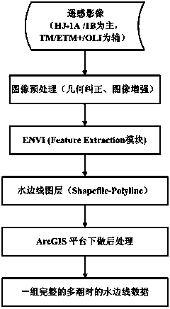
[0034] A tidal flat DEM calibration method based on remote sensing water edge, such as figure 1 shown, including the following steps:

[0035] 1. Collect multi-source and multi-temporal remote sensing images of the tidal flat area, and extract the water edge, such as figure 2 As shown; the multi-source and multi-temporal remote sensing images are the remote sensing images of each tidal time with a spatial resolution of 30 meters within half a year, and are mainly based on the HJ-1A / 1B images of the environment and disaster monitoring and forecasting small satellite constellation, Landsat series satellites TM / ETM+ / OLI image as a supplement; after preprocessing the image for geometric correction and image enhancement, use the Feature Extraction module of the object-oriented space in ENVI to extract the water edge, and input the result into ArcGIS sof...


PUM


Abstract

The invention discloses a method for calibrating a tidal flat DEM (digital elevation model) on the basis of remote sensing water lines. The method includes particular steps of collecting multi-source and multi-temporal remote sensing images of tidal flat regions and extracting the water lines; building an initial DEM according to historical terrain data; building a two-dimensional tidal level numerical simulation model on the basis of the initial DEM and verifying the model by the aid of measured tidal station data; computing tidal flat exposure regions at acquisition moments of the corresponding remote sensing images by the aid of the two-dimensional tidal level numerical simulation model, comparing the tidal flat exposure regions to the water lines at the corresponding moments, comparing the tidal flat exposure regions to a next water line if the tidal flat exposure regions are matched with the previous water lines, or correcting the tidal flat exposure regions if the tidal flat exposure regions are not matched the previous water lines; calibrating the DEM by the aid of the multiple water lines by the same process, matching all the water lines with the exposure regions computed by the aid of the two-dimensional tidal level numerical simulation model and outputting the optimal result of the DEM. The method has the advantages that the optimal realistic DEM data can be generated for the tidal flat regions with shortage in terrain data, the method is speedy, efficient, simple and feasible, and operation is convenient.

Description

technical field [0001] The invention relates to a tidal flat DEM calibrating method based on a remote sensing water edge, especially for constructing a DEM conforming to the status quo in tidal flat areas with rapid terrain changes. Background technique [0002] As a dynamic and unstable land resource, tidal flats are easily affected by global climate change, sea level change and human activities. The evolution of landforms often shows the characteristics of large erosion, large siltation, and changeable erosion and siltation. The terrain often changes in a short period of time. Great changes have taken place, and the previous terrain (DEM) data cannot meet the current needs. It is really necessary to study a simple and feasible method for real-time acquisition of tidal flat DEM. At present, there are four main methods for obtaining tidal flat topography (DEM): field survey, aerial survey, elevation inversion of remote sensing images, and composite technology of water edge ...

Claims


Application Information

Patent Timeline
Patent Type & Authority Applications(China)
IPC IPC(8): G06F17/50
Inventor 康彦彦丁贤荣夏娟
Owner HOHAI UNIV
Why Eureka
Try Eureka