SAR image road damaging information extracting method based on vector data

A vector data and information extraction technology, applied in image data processing, image analysis, instruments, etc., can solve the problem of road damage extraction that few people have set foot in

Active Publication Date: 2014-04-09
WUHAN UNIV
View PDF2 Cites 29 Cited by
  • Summary
  • Abstract
  • Description
  • Claims
  • Application Information

AI Technical Summary

Problems solved by technology

Although many scholars have studied the method of road extraction from SAR images, few people have been involved in the extraction of road damage from SAR images, especially high-resolution SAR images.

Method used


Image

  • SAR image road damaging information extracting method based on vector data
  • SAR image road damaging information extracting method based on vector data
  • SAR image road damaging information extracting method based on vector data

Examples


Embodiment Construction

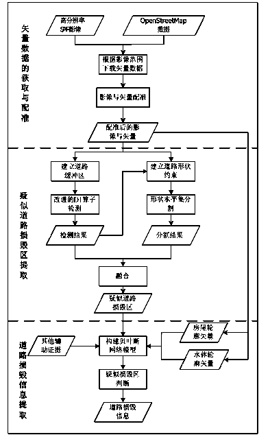
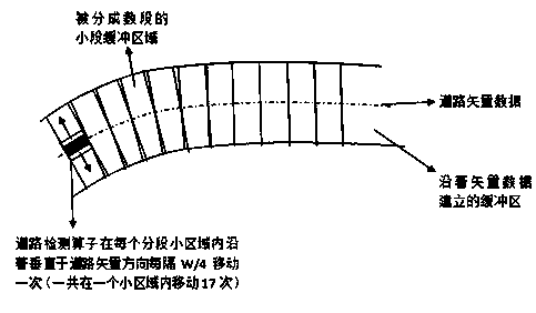
[0034] The invention provides a SAR image road damage extraction method aided by geographic information vector data. The main research content is road damage extraction from high-resolution SAR images, using geographic information vector data as prior information, and finding suspected road damage areas based on the improved buffer line detection and level set segmentation integration method. Further considering factors such as overlay, coherent speckle interference, and the complexity of the road background in the SAR image, the present invention adopts a Bayesian posterior probability model to conduct in-depth analysis on the suspected road damage area, and then extracts the road damage.

[0035] The technical solution of the present invention will be described in detail below in conjunction with the drawings and embodiments.

[0036] OpenStreetMap (OSM for short) is an open source online map collaboration project. Users can download various vector data (including road vecto...


PUM


Abstract

Provided is an SAR image road damaging information extracting method based on vector data. According to the range of SAR images after a disaster, vector data of a corresponding area are obtained; the vector data are projected to a coordinate system of the SAR images and then are registered on the SAR images; a suspected road damaging area of the SAR images is extracted, wherein a road detecting operator is used for line detecting, road width information and the road vector data are subjected to shape level set segmentation, and the road damaging area is obtained by fusion; and a Bayes network model is established to carry out further judging on the suspected road damaging area, and road damaging information is extracted. According to the method, the vector data are used as prior information for helping SAR image road changing detecting, detecting rate is high, a breaking zone can be well extracted through a method with line detecting and a shape level set being combined, the omission factor is low, interference information can be effectively removed through the established Bayes network model, and false alarm in road damaging extracting is lowered.

Description

technical field [0001] The invention relates to the technical field of remote sensing image processing, in particular to a method for extracting road damage information from high-resolution SAR images aided by vector data. Background technique [0002] Roads are the arteries of the country's economy and military, and are of great significance in both military and civilian uses. When various disasters occur, the lifeline of the road may be blocked, such as floods, landslides, mudslides and other natural disasters may cause road blockage, which greatly hinders the dispatch of rescue personnel and the delivery of relief materials to the disaster area. Disaster relief is a huge inconvenience. After the occurrence of natural disasters, since the method of manual field survey is a time-consuming and labor-intensive task, remote sensing technology has become an extremely important way to extract road damage due to the characteristics of "eyes in the sky". [0003] Looking at the ...

Claims


Application Information

Patent Timeline
Patent Type & Authority Applications(China)
IPC IPC(8): G06K9/46G06T7/00G06V10/764
CPCG06V20/182G06V10/764G06F18/24155
Inventor 眭海刚吴弦骏刘俊怡范一大陈光
Owner WUHAN UNIV
Why Eureka
Try Eureka