
Positioning monitoring system and method

A positioning monitoring and monitoring server technology, applied in satellite radio beacon positioning system, radio wave measurement system, service based on location information, etc., can solve the problem of large monitoring and alarm traffic

Active Publication Date: 2014-03-26
TECHTOTOP MICROELECTRONICS
View PDF6 Cites 13 Cited by
  • Summary
  • Abstract
  • Description
  • Claims
  • Application Information

AI Technical Summary

Problems solved by technology

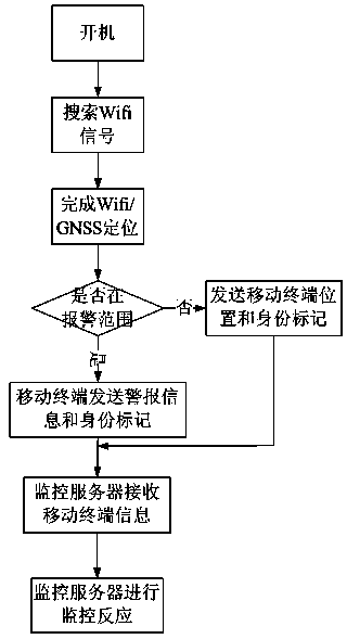
[0004] The purpose of the present invention is to provide a positioning monitoring system and method, which solves the problem of continuous positioning through Wi-Fi positioning and GNSS positioning technology, and places with poor GNSS signals are often places with rich Wi-Fi signals, which can Effectively make up for the lack of GNSS positioning, and Wi-Fi can also communicate, which solves the problem of large traffic generated by monitoring and alarming

Method used


Image

  • Positioning monitoring system and method
  • Positioning monitoring system and method
  • Positioning monitoring system and method

Examples


Embodiment Construction

[0023] In order to make the object, technical solution and advantages of the present invention clearer, the present invention will be further described in detail below in conjunction with the accompanying drawings and embodiments. It should be understood that the specific embodiments described here are only used to explain the present invention, not to limit the present invention.

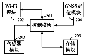
[0024] Such as figure 1 As shown, the system of the present invention mainly includes 3 parts, mobile terminals, such as current mobile phones, PADs, notebook computers or data tags with transceiver functions, etc., among the examples listed above, especially mobile phones have a very wide range of applications, and currently Most of the smart phones basically have Wi-Fi function, and have operating systems such as IOS or Android system, etc., and can install third-party application software, so as to easily realize customized functions.

[0025] Wi-Fi hotspots, with the acceleration of urbaniza...


PUM


Abstract

The invention provides a positioning monitoring system. The positioning monitoring system comprises a mobile terminal, and a monitoring server. The system further at least comprises three Wi-Fi hotspots. The mobile terminal is used to perform positioning through the Wi-Fi hotspots, and sending the monitoring result to the monitoring server. The invention further provides a positioning monitoring method using the positioning monitoring system. By adopting the technical scheme of the invention, continuous real-time positioning monitoring can be performed on a monitored object, and effective alarming can be realized through preset alarming conditions.

Description

technical field [0001] The present invention relates to location information service technology, more specifically to a positioning monitoring system and method based on Wi-Fi and GNSS joint positioning. Background technique [0002] GNSS (Global Navigation Satellite System, GNSS) uses navigation satellites for timing, positioning and ranging, and can provide all-weather, all-round and continuous real-time high-precision three-dimensional space for sea, land and air users around the world. , speed and time information. At present, GNSS includes GPS of the United States, GLONASS of Russia, Galileo system of the European Union, and Beidou navigation system of China. Taking the GPS system as an example, the system is mainly composed of three parts, namely the space part, the ground control part and the user device part. The space part is composed of 24 satellites, which are distributed in 6 track planes. The ground control part is composed of the main control station responsi...

Claims


Application Information

Patent Timeline
Patent Type & Authority Applications(China)
IPC IPC(8): G01S19/48H04W4/02H04W84/12
CPCG01S19/48H04W4/021
Inventor 李国贤周善明
Owner TECHTOTOP MICROELECTRONICS
Learn More