
A shallow lake water surface imaging spectrum acquisition system and synchronous automatic monitoring method

An imaging spectrum and automatic monitoring technology, applied in the field of environmental remote sensing monitoring, can solve the problems of satellite data atmospheric correction errors, high operating costs, interference, etc., and achieve the effects of ensuring stable operation, rapid and stable operation, and improving capabilities

Inactive Publication Date: 2016-01-13
NANJING INST OF GEOGRAPHY & LIMNOLOGY +1
View PDF5 Cites 0 Cited by
  • Summary
  • Abstract
  • Description
  • Claims
  • Application Information

AI Technical Summary

Problems solved by technology

[0008] 1. The traditional instrument for obtaining spectral information on the surface of water is a non-imaging spectrometer. The spectrometer actually obtains the information of a certain point on the water surface, but the specific location of the point cannot be accurately judged and can only give an approximate range. For complex and changeable eutrophication As far as water bodies are concerned, it is not conducive to accurately obtain information such as water quality, hydrology, and underwater light fields that are synchronized with spectral information;
[0009] 2. The traditional research method for spatial scale conversion of remote sensing information is based on satellite images with different spatial resolutions. However, the transit time of different satellites is not consistent, and the spatial resolution of satellite images is too rough (a few meters to hundreds of meters). In addition, , the immature atmospheric correction technology for second-class water bodies, resulting in significant errors in the atmospheric correction of satellite data, which will cause severe interference to the water body information with weak signals, directly affecting the accuracy of the final monitoring results
Imaging spectrometers can be mounted on space-based platforms such as drones, but their operating costs are high, and it is difficult to obtain remote sensing information with different spatial resolutions of the same research area at different heights in a short time interval.

Method used


Image

  • A shallow lake water surface imaging spectrum acquisition system and synchronous automatic monitoring method
  • A shallow lake water surface imaging spectrum acquisition system and synchronous automatic monitoring method
  • A shallow lake water surface imaging spectrum acquisition system and synchronous automatic monitoring method

Examples


Embodiment 1

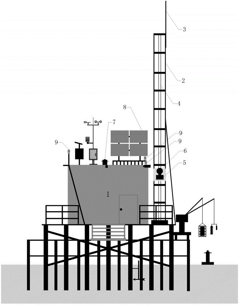
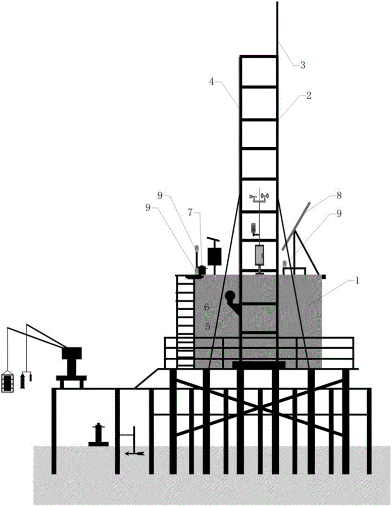
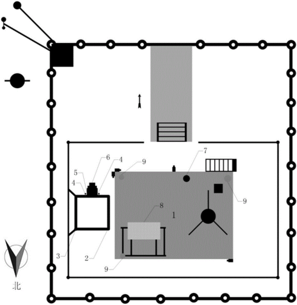
[0060] Figure 1a , 1b 1c and 1d are schematic diagrams of the structure of the present invention. As shown in the figure, a shallow lake water surface imaging spectrum automatic monitoring system includes a support platform, a power supply system, an imaging spectrum data collector system, a data transmission system, and a data center.

[0061] The supporting platform must be 1m higher than the historically highest water level in the water area. It is supported by a total of 48 pipe piles, each of which is 8m long, and is driven into the bottom of the lake about 3m. The anticorrosive wood partition (ie platform) is laid on it, and the platform is set on it. Rainproof instrument room, and in order to facilitate platform operations, a stainless steel ladder can be welded to the roof on one side of the instrument room, and the imaging spectrometer observation tower 2 on the other side. This platform system can withstand a great load, can maintain sufficient stability under the attack...

Embodiment 2

[0068] image 3 It is a flowchart of the present invention. As shown in the figure, an automatic monitoring method using the shallow lake water surface imaging spectrum automatic monitoring system described in the first embodiment includes the following steps:

[0069] (1) On a sunny day, solar panels 8 are used to convert solar energy into electrical energy and stored in the battery pack 11; the battery pack 11 is the data collector system (including the navigation light 9, the water surface imaging spectrum acquisition system 6 and the communication module 12). source;

[0070] (2) Use the camera to collect the video image of the water surface within a radius of 500m; then according to the characteristics of the algae bloom or water color change on the lake surface, the water color change information in the image is extracted and transmitted to the data center through the built-in program of the data transmission system, and the appropriate time is selected for development Experi...


PUM


Abstract

The invention discloses an automatic spectrum monitoring system for the water surface imaging of a shallow lake and a synchronous automatic monitoring method. The system comprises a support platform, a power supplying system, a data collector system, a data transmission system and a data center; the support platform comprises a platform formed by a plurality of pile supports and an instrument room built on the platform; the power supplying system supplies power for the data collector system and the data transmission system; the data collector system comprises an imaging spectrometer and a matched observation tower frame; the data transmission system is connected with the data collector system and transmits the water surface imaging spectrum remote sensing information collected by the data collector system to the data center. The spectrum collecting system for the water surface imaging of the shallow lake and the synchronous automatic monitoring method are suitable for the remote sensing field monitoring and research on the water color and the algae bloom, converted under a region expansion space size, of the area with the characteristics of relative immobilization and high frequency of an algae bloom generating position of the eutrophication lake.

Description

Technical field [0001] The invention belongs to the field of environmental remote sensing monitoring, and relates to a shallow lake water surface imaging spectrum acquisition system and a monitoring method thereof. Background technique [0002] The spectral characteristics of water bodies are the external characteristics of the composition of water bodies, and the types and contents of water bodies can be analyzed by using remote sensing reflectance of water bodies measured in the field. [0003] The water spectrum characteristics of water from visible light to near-infrared bands are mainly manifested as: about 412nm can reflect yellow substances and debris, 443nm can reflect the absorption peak of medium and low concentrations of chlorophyll, and about 490nm can reflect the absorption peak of medium and high concentrations of chlorophyll, 510nm Can reflect the suspended sediment and red tide, about 560nm can reflect the concentration of suspended sediment, and the minimum chlorop...

Claims


Application Information

Patent Timeline
Patent Type & Authority Patents(China)
IPC IPC(8): G01J3/28G08C17/02G01N21/25
Inventor 张玉超马荣华王新雨
Owner NANJING INST OF GEOGRAPHY & LIMNOLOGY
Learn More