Method for indexing scattered point cloud space of historic building

A technology of ancient buildings and scattered points, which is applied in the field of point cloud indexing, can solve problems such as single resolution and data redundancy, and achieve the effects of simple implementation, high query efficiency, and high indexing efficiency

Inactive Publication Date: 2014-01-29
BEIJING UNIV OF CIVIL ENG & ARCHITECTURE
View PDF6 Cites 13 Cited by
  • Summary
  • Abstract
  • Description
  • Claims
  • Application Information

AI Technical Summary

Problems solved by technology

[0004] In view of the above technical problems, the present invention designs and develops a method for spatial indexing of scattered point clouds of ancient buildings. The purpose is to solve the problems of single resolution and data redundancy while maintaining the advantages of simple grid indexing algorithm and high query efficiency. , reduce the amount of data in each query, and ensure the query efficiency of the K-D tree

Method used


Image

  • Method for indexing scattered point cloud space of historic building

Examples


Embodiment Construction

[0022] The present invention will be further described in detail below in conjunction with the accompanying drawings, so that those skilled in the art can implement it with reference to the description.

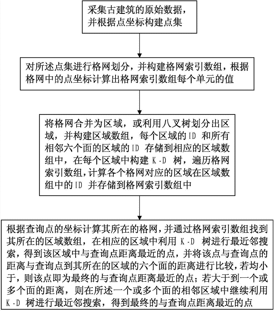
[0023] Such as figure 1 As shown, the present invention provides a method for spatial indexing of scattered point clouds of ancient buildings, comprising the following steps:

[0024] Step 1. Collect the original data of ancient buildings, and construct a point set according to the point coordinates, marked as {X};

[0025] Step 2. Carry out grid division on the point set {X}, construct a grid index array, and calculate the value of each unit of the grid index array according to the point coordinates in the grid;

[0026] Step 3. Set the minimum threshold for the number of points contained in the grid, merge the grids with points less than the minimum threshold into regions, or use the octree to divide the region, and set the threshold for the number of points contained in t...


PUM


Abstract

The invention relates to the field of point cloud indexing, in particular to a method for indexing scattered point cloud space of a historic building. The method is characterized by including steps of acquiring a data construction point set; gridding the point set, setting grid index digit groups, and calculating value of each unit of the grid index digit groups according to point coordinates in grids; merging the grids into an area or dividing an area by an octree, setting area digit groups, storing ID (identification) of each area and IDs of the areas of all adjacent six sides into the corresponding digit group, constructing a K-D tree in each area, traversing grid index digit groups, and calculating IDs the areas corresponding to the grid in the area digit groups; looking for the grids and the areas where inquired points locate according to coordinates of the inquired points, indexing in the areas and the adjacent areas by means of the K-D tree and obtaining the point nearest to the inquired point. The method solves the problems of single resolution ratio and data redundancy, and guarantees inquiry efficiency of the K-D tree.

Description

technical field [0001] The invention relates to the field of point cloud indexing, in particular to a method for spatial indexing of scattered point clouds of ancient buildings. Background technique [0002] Spatial index refers to a data structure arranged in a certain order according to the position and shape of spatial objects or a certain spatial relationship between spatial objects, which contains the summary information of spatial objects. Point cloud data of ancient buildings has the characteristics of large data volume (massiveness), fine data expression (high spatial resolution), and no topological relationship (scattering) between spatial three-dimensional points. Neighborhood search, so data organization and indexing must be carried out to improve the speed of subsequent neighborhood retrieval and query operations. [0003] For point cloud data, octree and K-D tree indexes are often used. The octree algorithm is simple to implement, but it is more suitable for ev...

Claims


Application Information

Patent Timeline
Patent Type & Authority Applications(China)
IPC IPC(8): G06F17/30
CPCG06F16/9027G06F16/903
Inventor 赵江洪王晏民张瑞菊郭民
Owner BEIJING UNIV OF CIVIL ENG & ARCHITECTURE
Why Eureka
Try Eureka