Scenic area navigation system based on bar code scanning technique
A barcode scanning and navigation system technology, which is applied in the field of scenic spot navigation system based on barcode scanning technology, can solve the problems of tourists being discouraged, easy to take the wrong route, and increasing the pressure on scenic spot facilities, so as to reduce pressure and facilitate monitoring and management.
- Summary
- Abstract
- Description
- Claims
- Application Information
AI Technical Summary
Problems solved by technology
Method used
Image
Examples
Embodiment 1
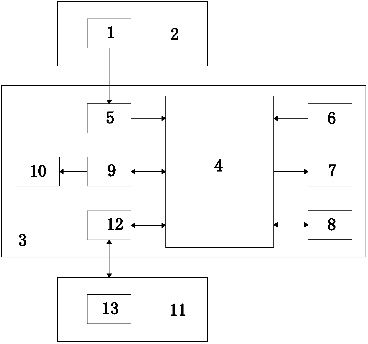
[0023] Embodiment 1 of the present invention: a scenic spot navigation system based on barcode scanning technology, such as figure 1 As shown, it includes a ticket 2 with a barcode 1 and a mobile phone 3; the mobile phone 3 is provided with a main control unit 4, and the mobile phone 3 is also provided with a barcode scanning module 5, a GPS module 6 and a display module 7 connected to the main control unit 4 ;
[0024] The barcode scanning module 5 is used to scan the barcode 1 on the ticket 2 to obtain the map data of the scenic spot;
[0025] GPS module 6, is used for obtaining the coordinate data of the tourist's position that holds this mobile phone 3;
[0026] The display module 7 is used to display the position of tourists on the map of the scenic spot.
[0027] The mobile phone 3 is provided with a route planning algorithm storage module 8 connected to the main control unit 4, which is used to store the algorithm for planning the travel route according to the map dat...
Embodiment 2
[0035] Embodiment 2 of the present invention: a scenic spot navigation system based on barcode scanning technology, such as figure 1 As shown, it includes a ticket 2 with a barcode 1 and a mobile phone 3; the mobile phone 3 is provided with a main control unit 4, and the mobile phone 3 is also provided with a barcode scanning module 5, a GPS module 6 and a display module 7 connected to the main control unit 4 ;
[0036] The barcode scanning module 5 is used to scan the barcode 1 on the ticket 2 to obtain the map data of the scenic spot;
[0037] GPS module 6, is used for obtaining the coordinate data of the tourist's position that holds this mobile phone 3;
[0038] The display module 7 is used to display the position of tourists on the map of the scenic spot.
[0039] The mobile phone 3 is provided with a route planning algorithm storage module 8 connected to the main control unit 4, which is used to store the algorithm for planning the travel route according to the map dat...
PUM
 Abstract
Description
Claims
Application Information
 - R&D
- Intellectual Property
- Life Sciences
- Materials
- Tech Scout
- Unparalleled Data Quality
- Higher Quality Content
- 60% Fewer Hallucinations
Browse by: Latest US Patents, China's latest patents, Technical Efficacy Thesaurus, Application Domain, Technology Topic, Popular Technical Reports.
© 2025 PatSnap. All rights reserved.Legal|Privacy policy|Modern Slavery Act Transparency Statement|Sitemap|About US| Contact US: help@patsnap.com

