
Map matching-assistant indoor positioning method

A positioning method and map matching technology, which can be used in wireless communication services, electrical components, wireless communication, etc., and can solve problems such as computational redundancy.

Active Publication Date: 2013-10-23
严格集团股份有限公司
View PDF3 Cites 19 Cited by
  • Summary
  • Abstract
  • Description
  • Claims
  • Application Information

AI Technical Summary

Problems solved by technology

[0004] In order to solve the problem that the existing indoor map matching algorithm requires additional measurement data from sensors and iterative algorithm search process, resulting in redundant calculations, the present invention provides a map matching-assisted indoor positioning method

Method used


Image

  • Map matching-assistant indoor positioning method
  • Map matching-assistant indoor positioning method
  • Map matching-assistant indoor positioning method

Examples


specific Embodiment approach 1

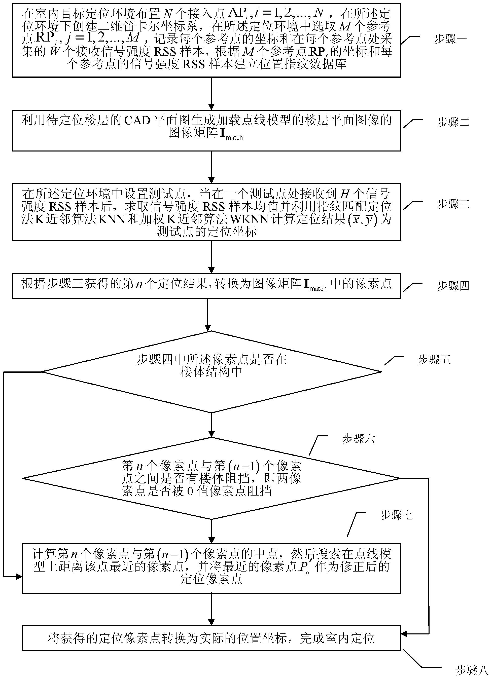
[0030] Specific implementation mode 1. Combination figure 1 This specific embodiment will be described. A map matching assisted indoor positioning method, it comprises the following steps:

[0031] Step 1: Arrange N access points AP in the indoor target positioning environment i ,i=1,2,...,N, create a two-dimensional Cartesian coordinate system in the positioning environment, and select M reference points RP in the positioning environment j ,j=1,2,...,M, record the coordinates of each reference point and W received signal strength RSS samples collected at each reference point, according to M reference points RP j The coordinates and the signal strength RSS samples of each reference point establish a location fingerprint database;

[0032] Step 2: Use the CAD plan of the floor to be located to generate the image matrix I of the floor plan image of the loaded point-line model match ;

[0033] Step 3: Set test points in the positioning environment. After receiving H signal s...

specific Embodiment approach 2

[0039] Specific embodiment two, the difference between this specific embodiment and specific embodiment one is described step 2: Utilize the CAD plan of the floor to be positioned to generate the image matrix I of the floor plan image of the loaded point line model match The process is:

[0040] After the point-line model is loaded into the CAD plan of the floor, a CAD plan of the loaded point-line model can be obtained; the CAD plan after loading the point-line model and the original CAD plan are respectively saved as pictures; the two pictures are respectively Convert to two binary image matrices I model and I no_model;In these two binary image matrices, set the pixel points of people's daily activity area to value +1, and set the pixel points of the building structure and point-line model to value 0;

[0041] Get indoor map image matrix I match :

[0042] I no_model -2×(I model ⊕I no_model )=I match

[0043] Among them, ⊕ is an XOR operation. So, in the floor plan...

specific Embodiment approach 3

[0044] Specific embodiment three, the difference between this specific embodiment and specific embodiment one or two is that the step three: set test points in the positioning environment, after receiving H signal strength RSS samples at a test point, Find the average value of the signal strength RSS sample and use the fingerprint matching positioning method K-nearest neighbor algorithm KNN and weighted K-nearest neighbor algorithm WKNN to calculate the positioning result The process of positioning coordinates for the test point is:

[0045] According to the fingerprint matching positioning method K nearest neighbor algorithm KNN to obtain the formula:

[0046] D i = ( Σ j = 1 ...


PUM


Abstract

The invention discloses a map matching-assistant indoor positioning method which relates to a map matching-assistant positioning method and is used for solving a redundant calculation problem which is caused by additional measurement data from a sensor and an iterative algorithm searching process which are required by an existing indoor map matching algorithm. The method comprises the steps of: arranging access points and reference points in an indoor target positioning environment and building a position fingerprint database; utilizing a computer-aided design (CAD) plan of a floor to be positioned to generate an image array Imatch for loading a floor plan image of a point-line model; calculating positioning coordinates of test points as positioning results; converting the positioning coordinates into pixel points, judging whether a building body, blocking a midpoint of the nth pixel point and the (n-1)th pixel point, exists between the nth pixel point and the (n-1)th pixel point, searching for the pixel point which is positioned on the point-line model and is nearest to the point, and utilizing the nearest pixel point as a revised positioning pixel point; and converting the obtained positioning pixel point into practical position coordinates, and completing indoor positioning. The method can be widely applied to indoor positioning.

Description

technical field [0001] The invention relates to a map matching auxiliary positioning method. Background technique [0002] Map matching assisted positioning technology has become an important part of land vehicle navigation system. High-precision digital maps can not only provide drivers with vehicle location information, but can also be used to improve the positioning performance of integrated navigation systems. At present, this technology has been widely used in outdoor vehicle navigation and positioning. In the field of indoor positioning, the randomness of user movement in diverse indoor environments increases the difficulty of applying map matching technology in indoor environments. At the same time, in indoor complex radio environments, due to various errors, the positioning results obtained by WLAN-based fingerprint matching indoor positioning methods may deviate from people's normal activity areas. Therefore, the map matching algorithm can use map information to ...

Claims


Application Information

Patent Timeline
IPC IPC(8): H04W4/04H04W64/00
Inventor 徐玉滨孙永亮马琳沙学军
Owner 严格集团股份有限公司
Learn More