
Bus positioning method based on double-beacon and double-module communication

A positioning method and bus technology, applied in traffic control systems, traffic control systems of road vehicles, instruments, etc., can solve problems such as abnormal communication links, inability to locate, and easy disconnection

Inactive Publication Date: 2013-09-11
上海新兴媒体信息传播有限公司
View PDF5 Cites 14 Cited by
  • Summary
  • Abstract
  • Description
  • Claims
  • Application Information

AI Technical Summary

Problems solved by technology

[0004] GPS positioning: It is the most widely used positioning technology. The disadvantage is that in the "urban canyons" such as major urban CBDs and urban tunnels, and in natural canyons, GPS positioning may have trouble
[0008] (1) Although the cost-effectiveness of GPS positioning modules has made great progress in recent years, including the significant improvement in sensitivity and noise indicators, it will still be impossible to locate under elevated roads and tunnels in big cities, and in business districts with many high-rise buildings. Residential areas will have positioning drift due to the "canyon effect"
[0009] (2) There are technical defects in the single data return channel
At present, the communication module of the bus terminal is commonly used as the GPSR communication module. This wireless communication method has some inherent defects, such as low uplink rate, easy disconnection, and in some areas where the coverage of mobile base stations is insufficient, it cannot even communicate normally for a short time.
[0010] (3) At present, the data collection and reporting mechanism generally designed by vehicle-mounted GPS terminals is 200-meter displacement or 20-second interval or event trigger
[0011] In reality, the error caused by the current GPS positioning offset exceeds 100 meters, or even 200 meters; the average communication delay of GPRS is 10 to 20 seconds (the ideal value is 10 seconds, and the delay of more than 30 seconds is also common); plus the aforementioned The vehicle information collection data triggers the return mechanism, which leads to the most important thing is to make real-time arrival forecast. The off-the-shelf vehicle GPS data can actually only be used as auxiliary data and historical data, and even when only station-level forecasts are made, it must be done during the "coming soon" forecast. It's hard to be accurate
[0012] In order to overcome the defects of a single positioning method and overcome the abnormal communication link caused by a single communication module, it is necessary to reform the bus positioning method

Method used


Image

  • Bus positioning method based on double-beacon and double-module communication
  • Bus positioning method based on double-beacon and double-module communication
  • Bus positioning method based on double-beacon and double-module communication

Examples


Embodiment Construction

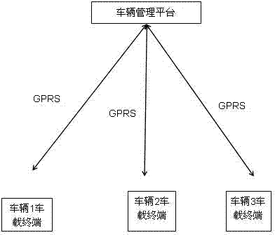
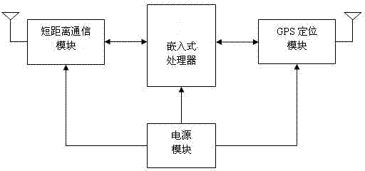
[0039] Bus positioning equipment based on dual beacons and dual-mode communication, including tags and poles, such as figure 2 As shown in the structural diagram of the tag in the implementation of the present invention, a tag includes a short-distance communication module and a GPS positioning module, powered by a power supply module, and connected to an embedded processor respectively, and is connected with RFID-based beacon positioning and GPS positioning The combined vehicle-mounted intelligent terminal is independently installed on the bus, and the GPS vehicle positioning information is uploaded to the vehicle management platform through GPRS.

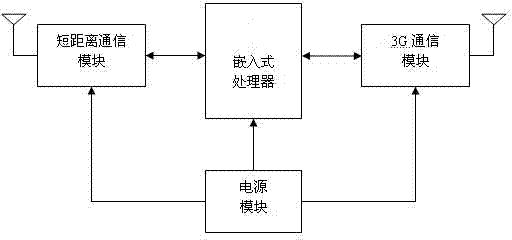
[0040] Such as image 3 As shown in the structural diagram of the benchmarking pole in the implementation of the present invention, a benchmarking pole includes a short-distance communication module and a 3G communication module, powered by a power supply module, and respectively connected with embedded processors, and uploading ...


PUM


Abstract

The invention relates to a bus positioning method based on double-beacon and double-module communication. A label device of a vehicle-mounted terminal based on a radio frequency identification (RFID) technique is installed on a bus, and a benchmark device comprising a card reader and an information releasing unit are arranged in an intermediate terminal bus shelter. A double-beacon mode is adopted for positioning the bus, a vehicle-mounted intelligent terminal based on combination of RFID beacon positioning and global positioning system (GPS) positioning serves as the main beacon, a short-distance communication module and an independent GPS module are combined to serve as an auxiliary beacon, a communication module is additionally arranged in the intermediate terminal bus shelter to serve as an auxiliary information channel, and the short-distance communication module and a remote wireless communication module are arranged in the information releasing unit of the intermediate terminal bus shelter. A communication device of the intermediate terminal bus shelter and the vehicle-mounted intelligent terminal of the bus adopt different wireless communication operators. Effective data amount of the bus positioning method is 2.5 times as that of the vehicle-mounted terminal, and 99% of data of a label are delayed within 15 seconds, and information is accurate and timely.

Description

technical field [0001] The invention relates to a bus positioning method, in particular to a bus positioning method based on dual beacons and dual-mode communication. Background technique [0002] With the continuous acceleration of urbanization in contemporary society, more and more people begin to gather in cities. Traffic problems are generally encountered in various cities. Traffic jams are frequent and roads are congested, so vigorously developing public transportation has become an effective way for cities to relieve traffic pressure. As the main travel tool for urban residents, buses have always been concerned by the majority of passengers for their service quality. [0003] Therefore, at present, almost all buses in the urban area of ​​Shanghai are equipped with special bus terminals, so it is imminent to provide bus information services through the bus terminals. Common vehicle positioning technologies include the following technologies: Global Positioning System...

Claims


Application Information

Patent Timeline
IPC IPC(8): G08G1/127
Inventor 吴兵肖俊朱道圣郭征茜
Owner 上海新兴媒体信息传播有限公司
Learn More