A virtual environment system for remote sensing satellite ground data processing grid nodes

A data processing system and grid node technology, applied in the field of virtual environment construction, can solve problems such as interruptions and affect the operation of existing systems, and achieve the effects of good scalability, convenient simulation and verification, and security assurance

Active Publication Date: 2016-06-08
CHINA CENT FOR RESOURCES SATELLITE DATA & APPL
View PDF3 Cites 0 Cited by
  • Summary
  • Abstract
  • Description
  • Claims
  • Application Information

AI Technical Summary

Problems solved by technology

These methods put forward solutions from different angles, but because they are all directly connected to the grid platform, it is inevitable to partially transform the original business system, interrupt or affect the operation of the existing system business

Method used


Image

  • A virtual environment system for remote sensing satellite ground data processing grid nodes
  • A virtual environment system for remote sensing satellite ground data processing grid nodes
  • A virtual environment system for remote sensing satellite ground data processing grid nodes

Examples


Embodiment Construction

[0016] In order to better understand the present invention, a detailed description of the application of the present invention will be made below.

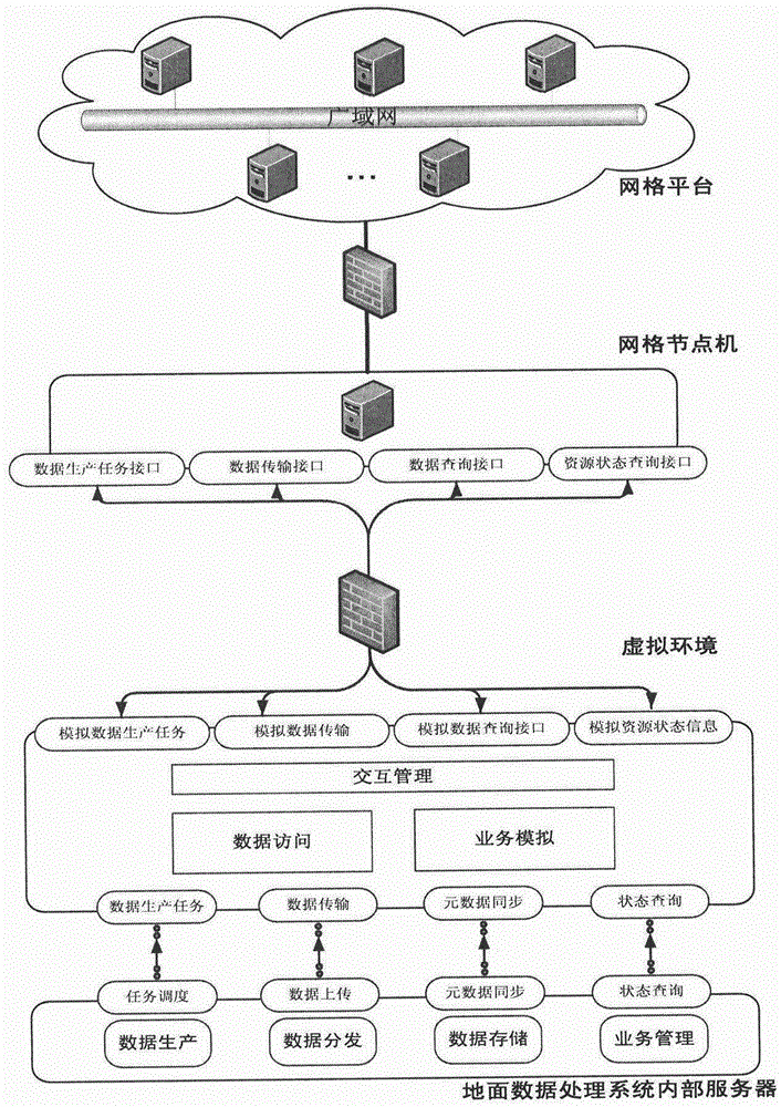
[0017] The present invention is a virtual environment system for the grid node of the satellite ground data processing system, such as figure 1 As shown, it is mainly to connect the resources in the satellite ground data processing system to the grid platform without affecting the existing business; because the data and services of the existing satellite ground data processing system are very complicated, they cannot be directly connected to the external network grid, a virtual business environment is required as a transition. The virtual environment simulates various states of the real business, and forwards the grid request to the internal server of the ground data processing system. At the same time, external grid users access the internal server of the ground data processing system through the grid terminal and the virtual env...


PUM


Abstract

The invention relates to a virtual environment system for a remote sensing satellite ground data processing grid node. The system comprises an interactive management module, a data access module and a service simulation module which operate on a server virtualized by VMware virtual software, wherein the VMware virtual software operates on a physical server; the interactive management module is used for receiving data inquiry, task state inquiry and resource state inquiry instructions transmitted by a user or a task order of data production and transmitting the received instructions to the service simulation module; the received data inquiry result, the task state inquiry result, the resource state inquiry result and the data production state are transmitted to the user and displayed; the service simulation module is used for storing metadata in a satellite ground data processing system in the local and simulating the corresponding function of the satellite ground data processing system according to the received instructions; and the data access module is used for caching the received data product according to the received data production state, pushing the data product to the user and transmitting the data transmission state to the interactive management module.

Description

technical field [0001] The invention relates to a construction technology of a virtual environment, which is suitable for system integration and data integration of remote sensing satellite ground systems. Background technique [0002] The remote sensing satellite ground system is divided into multiple business links such as data receiving system, data processing system, task management system, application system, and end users. The association requirements of the business itself make there are a large amount of data exchange and business collaboration between each link. Therefore, it is necessary to establish a data sharing service grid platform to effectively solve the problem of ground system integration in a distributed heterogeneous network environment, realize the overall unified management and organization of resources, and realize the sharing of remote sensing satellite data resources between nodes. It can perform one-stop search for various remote sensing satellite ...

Claims


Application Information

Patent Timeline
Patent Type & Authority Patents(China)
IPC IPC(8): G06F9/455H04L29/08
Inventor 万伟孙业超王峰
Owner CHINA CENT FOR RESOURCES SATELLITE DATA & APPL
Why Eureka
Try Eureka