Automatic registration method for multi-source remote sensing images based on J-divergences

A remote sensing image and automatic registration technology, applied in the field of computer vision and remote sensing, can solve the problems of high mutual information image mismatch, low efficiency, coherence difference, etc., and achieve the effect of expanding the feasible search space and improving the robustness.

Inactive Publication Date: 2013-02-20
SUN YAT SEN UNIV
View PDF2 Cites 9 Cited by
  • Summary
  • Abstract
  • Description
  • Claims
  • Application Information

AI Technical Summary

Problems solved by technology

In current practical applications, manual selection of control points is often used for polynomial registration, which is less efficient
[0005] None of the existing automatic registration models in the prior art can solve the registration problem of multi-source remote sensing images well, such as using mutual information as a similarity index to register remote sensing images, and mutual information is more sensitive to noise in remote sensing images , the multi-source remote sensing image automatic registration model using mutual information as the similarity index is not very robust, and it cannot guarantee that the mutual information at the time of complete registration can obtain a global consensus during the entire image registration process. The maximum value, the high mutual information that occurs when the overlap is low, is prone to image misalignment, especially when the coherence difference is obvious and the high-noise images (such as optical images and radar images) are registered, this phenomenon is more obvious
At this time, the only way to limit the search space of the optimization algorithm is to search only around the transformation parameters corresponding to the complete registration, or to require a high overlapping area between the image to be registered and the reference image, which greatly limits the automatic registration model. Applications

Method used


Image

  • Automatic registration method for multi-source remote sensing images based on J-divergences
  • Automatic registration method for multi-source remote sensing images based on J-divergences
  • Automatic registration method for multi-source remote sensing images based on J-divergences

Examples


Embodiment Construction

[0035] The technical solutions of the present invention will be further described below in conjunction with the accompanying drawings and embodiments.

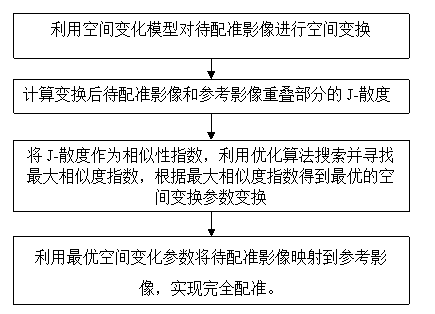
[0036] Such as figure 1 Shown is the flow chart of the method of the present invention. A method for automatic registration of multi-source remote sensing images based on J-divergence, the specific steps are as follows:

[0037] (S1) Using the spatial variation model to perform spatial transformation on the image to be registered;

[0038] (S2) Calculate the J-divergence of the overlapping part of the transformed image to be registered and the reference image, where each calculated J-divergence is equivalent to the objective function value corresponding to a set of spatial transformation parameters in the transformed space; the specific steps yes:

[0039] (S21) extracting the joint histogram of the overlapping parts of the transformed image to be registered and the reference image;

[0040] (S22) Calculate the edge densit...


PUM


Abstract

The invention relates to the computer vision and remote sensing field, in particular to an automatic registration method for multi-source remote sensing images based on J-divergences. The method comprises performing spatial transformation on an image to be registered through a spatial transformation model; calculating J-divergences of an overlap part of the image to be registered after transformation with a reference image, wherein, each of the calculated J-divergences is equivalent to a objective function value corresponding to a group of spatial transformation parameters in transformation space; using the J-divergences as similarity indexes, searching and seeking for a maximum similarity index through an optimization algorithm, and obtaining an optimum spatial transformation parameter according to the maximum similarity index; and using the optimum spatial transformation parameter to map the image to be registered to the reference image to achieve complete registration. By using the J-divergences as similarity indexes for remote sensing image registration, the problem of mutual information sensitivity to noise and overlap degrees is solved, the feasible search space of similarity indexes is expanded, and the model robustness is improved.

Description

technical field [0001] The invention relates to the fields of computer vision and remote sensing, in particular to an automatic registration method for multi-source remote sensing images based on J-divergence. Background technique [0002] With the rapid development of digital communication technology and aerial photography technology, modern remote sensing technology has been able to obtain ground observation data dynamically and accurately through multiple means. The salient features of modern sensing technology are multi-sensor platforms, multi-resolution, multi-spectral and multi-temporal, which enable people to dynamically, quickly, accurately and timely acquire remote sensing images with different spatial resolutions, temporal resolutions and spectral resolutions . [0003] Different remote sensing platforms are equipped with different sensors. Common sensors generally image through visible light, thermal infrared, microwave and other bands. The remote sensing images...

Claims


Application Information

Patent Timeline
IPC IPC(8): G06T7/00
Inventor 黎夏许晓聪刘小平黄康宁梁嘉咏
Owner SUN YAT SEN UNIV
Why Eureka
Try Eureka