
Angle tracking system

An angular tracking and sub-system technology, applied in the radar field, can solve the problems of occupying satellite resources, being susceptible to interference, and having a short range of drones.

Active Publication Date: 2012-06-20
NANJING XINXUAN ELECTRONICS SYST ENG
View PDF4 Cites 30 Cited by
  • Summary
  • Abstract
  • Description
  • Claims
  • Application Information

AI Technical Summary

Problems solved by technology

At present, most of the domestic platforms use radio stations and other platforms to realize information transmission, but this method makes the UAVs close in range and narrow in bandwidth, which is very susceptible to interference; foreign countries use satellite communications, which solves the problem of UAVs in short distances and narrow bandwidths. Narrow and highly susceptible to interference problems, but takes up a lot of satellite resources

Method used


Image

  • Angle tracking system
  • Angle tracking system
  • Angle tracking system

Examples


Embodiment Construction

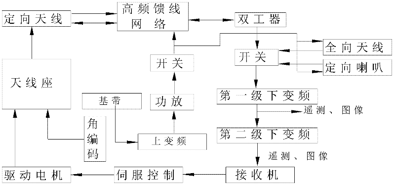
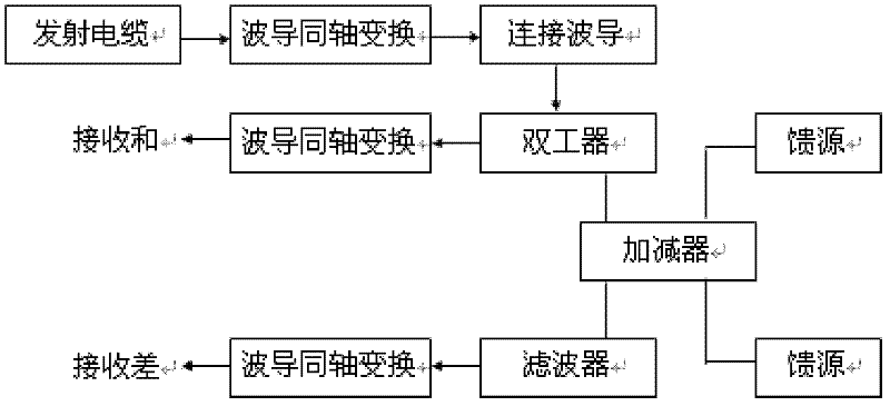
[0033] The ground vehicle angle tracking system of the UAV line-of-sight link of the present invention will be described in detail below in conjunction with the accompanying drawings and specific implementation.

[0034] Calculation of channel parameters, estimation of receiving link level, minimum receiving level P of receiving link Rmin Calculate according to the formula:

[0035] P Rmin =[E b / N c ]+[B]+[K]+[T]+[N F ]-[P G ];

[0036] In the formula: E b / N c The normalized signal-to-noise ratio is taken as 6.6dB (that is, corresponding to a bit error rate of 10 -5 , the demodulation threshold is 9.6dB, and then subtract the decoding gain of 3dB); B is the passband bandwidth; K Boltzmann constant: -228.6dB; T is the system noise temperature, which is taken as 298K (24.74dB); N F Receiver noise figure, taken as 2dB; P G Spread spectrum processing gain: 10lg0(0dB). After substituting each value into the above formula, the minimum receiving level P of the system rec...


PUM


Abstract

The invention provides an angle tracking system, which is characterized by comprising a control center, an antenna branch system, a feeder line branch system, an emission branch system, a receiving branch system, a servo branch system and a communication interface branch system. The angle tracking system can search, capture and track unmanned airplanes, precisely position the unmanned airplanes according to orientation information, elevation measurement information and information frame ranging information which are acquired by an angle tracking branch system, emit real-time remote control signals of a flying state of the unmanned airplane and a working state of airborne equipment, and receive real-time remote sensing signals of a flying parameter and detection information of the unmannedairplane and the working state of the airborne equipment; each working row channel is provided with a plurality of frequency points; and the working frequency band is wide, and the anti-interference performance is high.

Description

technical field [0001] The invention belongs to the field of radar, in particular to a ground vehicle angle tracking system for a line-of-sight link of an unmanned aerial vehicle. Background technique [0002] It has been more than a century since the British developed military drones in 1914. After unremitting efforts, drones have become an indispensable part of people's lives. At present, drones are used in various fields, such as geological exploration, meteorological monitoring, military and maritime inspections, etc. How to effectively feed the monitoring information on the UAV back to the control center has become an important direction of research. At present, most of the domestic platforms use radio stations and other platforms to realize information transmission, but this method makes the UAVs close in range and narrow in bandwidth, which is very susceptible to interference; foreign countries use satellite communications, which solves the problem of UAVs in short ...

Claims


Application Information

Patent Timeline
IPC IPC(8): G01S13/68
Inventor 谷义龙徐忠明张向东房福松沈春乐
Owner NANJING XINXUAN ELECTRONICS SYST ENG
Learn More