Aerial survey device and method for geomagnetic field intensity

A technology of magnetic field strength and aerial measurement, applied in the field of flight carriers, can solve the problems of low efficiency, low precision and low altitude of high-precision magnetic measurement on the ground, and achieve the effect of convenient transportation, small size and low cost

Inactive Publication Date: 2012-03-21
杨镜明 +1
View PDF2 Cites 14 Cited by
  • Summary
  • Abstract
  • Description
  • Claims
  • Application Information

AI Technical Summary

Problems solved by technology

[0003] Just in order to solve the problems of low precision of airborne magnetic method measurement and detection target body and low efficiency of ground high-precision magnetic survey existing in the above-mentioned prior art, the purpose of t...

Method used


Image

  • Aerial survey device and method for geomagnetic field intensity
  • Aerial survey device and method for geomagnetic field intensity
  • Aerial survey device and method for geomagnetic field intensity

Examples


Embodiment Construction

[0014] The preferred embodiments of the present invention will be described below in conjunction with the accompanying drawings. It should be understood that the preferred embodiments described here are only used to illustrate and explain the present invention, and are not intended to limit the present invention.

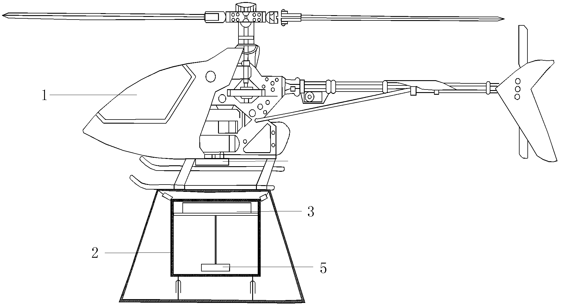
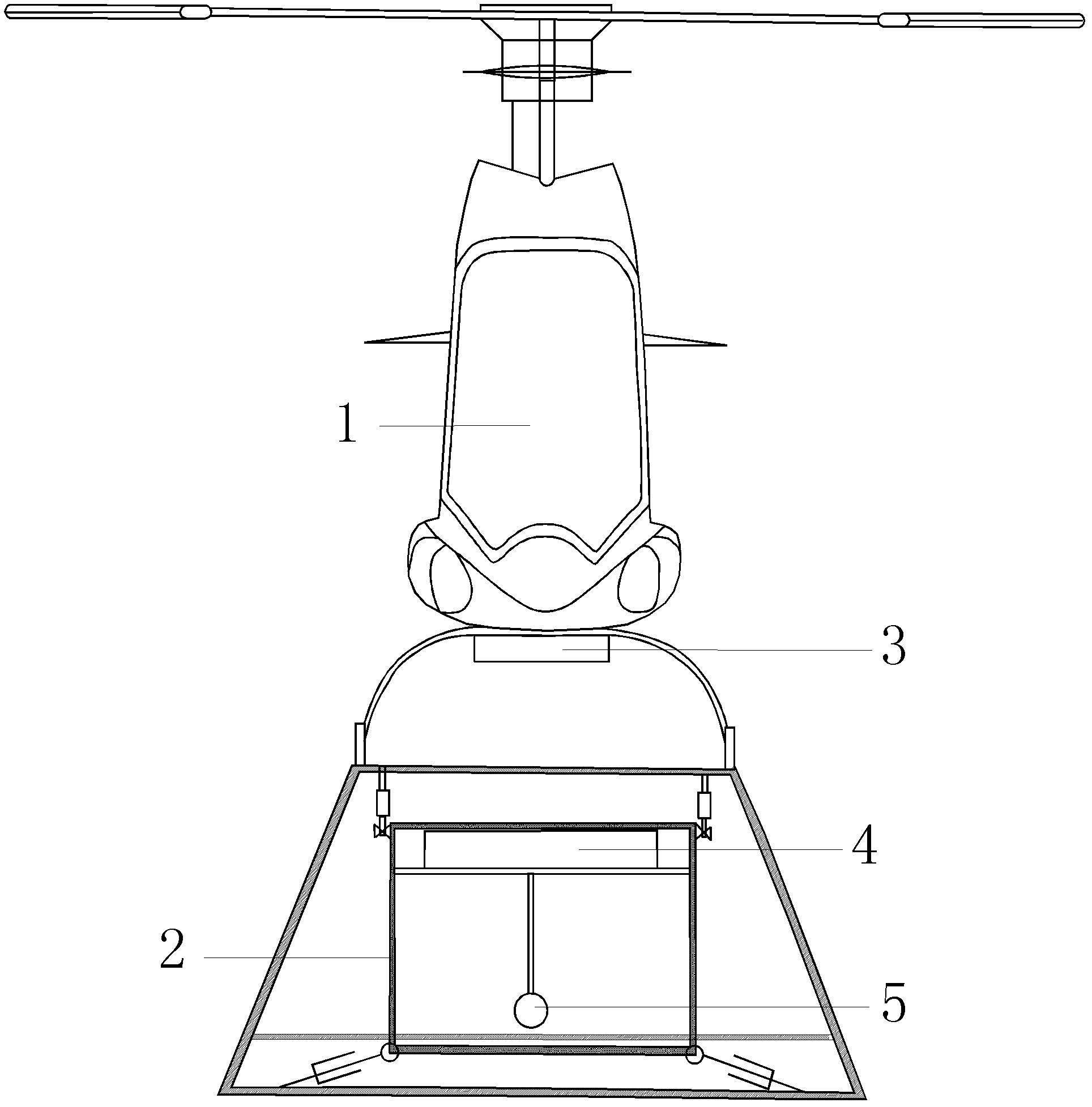
[0015] As shown in questions 1 and 2, an aeronautical device for measuring the strength of the geomagnetic field includes a model airplane helicopter 1, a magnetometer 4 and a flight control system. The model airplane helicopter 1 includes a body and a pan-tilt device 2. The magnetometer 4 is installed on On the cloud platform device 2 described above, the flight control system includes an airborne part and a ground station part, the flight control system airborne part 3 is installed on the aircraft model helicopter 1 body, and the flight control system airborne part 3 is connected to the ground The station part is connected by radio, and the flight control system ai...


PUM


Abstract

The invention provides an aerial survey device and method for geomagnetic field intensity. The aerial survey device comprises an aero-model helicopter, a magnetometer and a flight control system, wherein, the flight control system comprises an airborne part and a ground station part; and the airborne part is arranged on the aero-model helicopter body and is wirelessly connected with the ground station part. The aerial survey method comprises the following steps: the flight control system transfers flight status data of the aero-model helicopter, geographic and geomorphic photography data and magnetic survey data from the magnetometer to the ground station control system in real time; and the ground station control system controls the flight height and flight path of the aero-model helicopter according to the received data so that the magnetometer can acquire geomagnetic field intensity data. The contour-chasing high-precision magnetic survey device has the advantages of control capabilities for the contour-chasing flight height as well as hovering and low-speed flight, low cost, high safety, convenient carrying procedure, small overall volume, no need of an airport and auxiliary equipment during the takeoff and landing processes, no need of a pilot and the like.

Description

technical field [0001] The invention belongs to the technical field of magnetic measurement, and in particular relates to a device and method for carrying high-precision measurement of the strength of the geomagnetic field, and a flight carrier for realizing geological prospecting, exploration and environmental engineering investigation. Background technique [0002] At present, when geophysical methods and magnetic methods are used to detect the distribution of underground mineral deposits and solve geological problems on land, aerial surveys and ground surveys are generally used. Aerial surveys usually use manned fixed-wing aircraft or helicopters to carry surveyors and equipment for aeromagnetic surveys, which have the advantages of long time in the air, large-scale equipment, high measurement efficiency, regular survey network, and large amount of information. It has played an important role in the exploration of metallogenic belts, providing rich data for regional geolo...

Claims


Application Information

Patent Timeline
IPC IPC(8): G01V3/40
Inventor 杨镜明刘剑
Owner 杨镜明
Why Eureka
Try Eureka