Raster data type realization method and system for database system

A raster data and data type technology, applied in the field of information processing, can solve the problems of large data volume and difficult to maintain data consistency, achieve high retrieval efficiency, and solve the effects of concurrency and security risks

Inactive Publication Date: 2013-07-24
INST OF GEOGRAPHICAL SCI & NATURAL RESOURCE RES CAS +1
View PDF5 Cites 1 Cited by
  • Summary
  • Abstract
  • Description
  • Claims
  • Application Information

AI Technical Summary

Problems solved by technology

[0012] ●A large number of remote sensing data products are mainly stored in file formats such as GeoTiff, and the data volume is huge (a single satellite data center is often measured in hundreds of TB). It is almost impossible to import all of them into the database, and even if they are completely imported into the database for storage, the same copy Data needs to maintain two versions of file storage and database storage, and data consistency is difficult to maintain;

Method used


Image

  • Raster data type realization method and system for database system
  • Raster data type realization method and system for database system
  • Raster data type realization method and system for database system

Examples


specific Embodiment approach

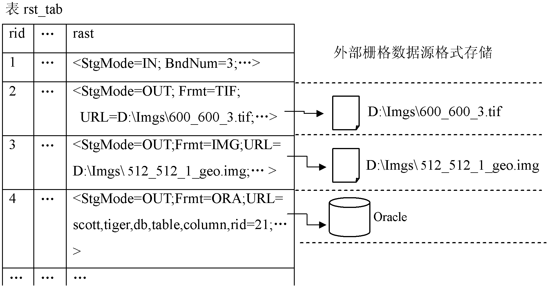
[0058] Take the record with rid=1 as an example: "StgMode=IN" in the field rast is used to indicate that the raster data stored in this record is stored locally, that is, the raster data is saved in the DBMS in the internal raster format of the database In the data file (data file inside the database), as for the specific storage format, reference may be made to patent US 2005 / 0055376A1, etc., which are not limited here.

[0059] Take the record with rid=2 as an example: the raster data saved in the field rast adopts the external storage mode, and is a file-type raster data, which specifically includes two parts, ① saved in the raster data type field Description of the external raster data source: "StgMode=OUT" is used to indicate that the raster data stored in this record is stored externally, "Frmt=TIF" indicates that the format of the external raster data source is Tiff format, "URL =D:\Imgs\600_600_3.tif" to record the link information of the path where the external raster...


PUM


Abstract

The invention discloses a raster data type realization method and system for a database system, and aims at the problems of difficulties in the realization of unified organization, high-efficiency integrated query and retrieval and concurrent secure accessing of large-scale raster data organized and stored in forms of GeoTiff file and the like. A conventional physical storage mode for a raster data type is expanded, local storage based on an in-database raster format and external storage based on an external raster data source format can be supported at the same time, and the high-efficiency integration and unified operations based on an SQL (structured query language) of the database system over internally and externally stored raster data are realized by the introduction of a unified mapping mechanism for data structures and the expansion of a conventional database system structure, comprising the expansion of an external storage driver and a raster logic object processor.

Description

technical field [0001] The invention mainly relates to information processing technology, in particular to a method and system for realizing grid data type in the kernel of a database management system. Background technique [0002] In recent years, with the rapid development of remote sensing and information detection technology, geospatial data is growing exponentially. How to efficiently organize and access massive geospatial data from multiple sources and at multiple scales has become an urgent need to solve the core question. [0003] Raster data is an important part of geospatial data. It is geospatial data stored in a pixel (or pixel) matrix structure. It is a general term for a type of data, covering remote sensing images, digital elevation models, grid data, etc. Specific forms, even ordinary photos are typical raster data. Since the geospatial data collected by the remote sensing platform basically belongs to raster data (that is, remote sensing data products), r...

Claims


Application Information

Patent Timeline
Patent Type & Authority Patents(China)
IPC IPC(8): G06F17/30
Inventor 谢炯姜平张明波陈荣国陈振程昌秀陈应东
Owner INST OF GEOGRAPHICAL SCI & NATURAL RESOURCE RES CAS
Why Eureka
Try Eureka