
Cruise image based imaging method of water-surface aerial view

An imaging method and bird's-eye view technology, applied in the field of image processing, can solve the problems of insufficient real-time monitoring, high monitoring cost, and easily affected monitoring accuracy.

Inactive Publication Date: 2011-02-16
NANJING UNIV
View PDF3 Cites 62 Cited by
  • Summary
  • Abstract
  • Description
  • Claims
  • Application Information

AI Technical Summary

Problems solved by technology

[0020] The problem to be solved by the present invention is: there are deficiencies in the monitoring of the water surface in the prior art, such as the requirements for monitoring large-area waters cannot be met, the real-time monitoring is not enough, the monitoring cost is high, and the monitoring accuracy is easily affected; a simple and easy to realize , a water surface monitoring method with high precision and good effect

Method used


Image

  • Cruise image based imaging method of water-surface aerial view
  • Cruise image based imaging method of water-surface aerial view
  • Cruise image based imaging method of water-surface aerial view

Examples


Embodiment Construction

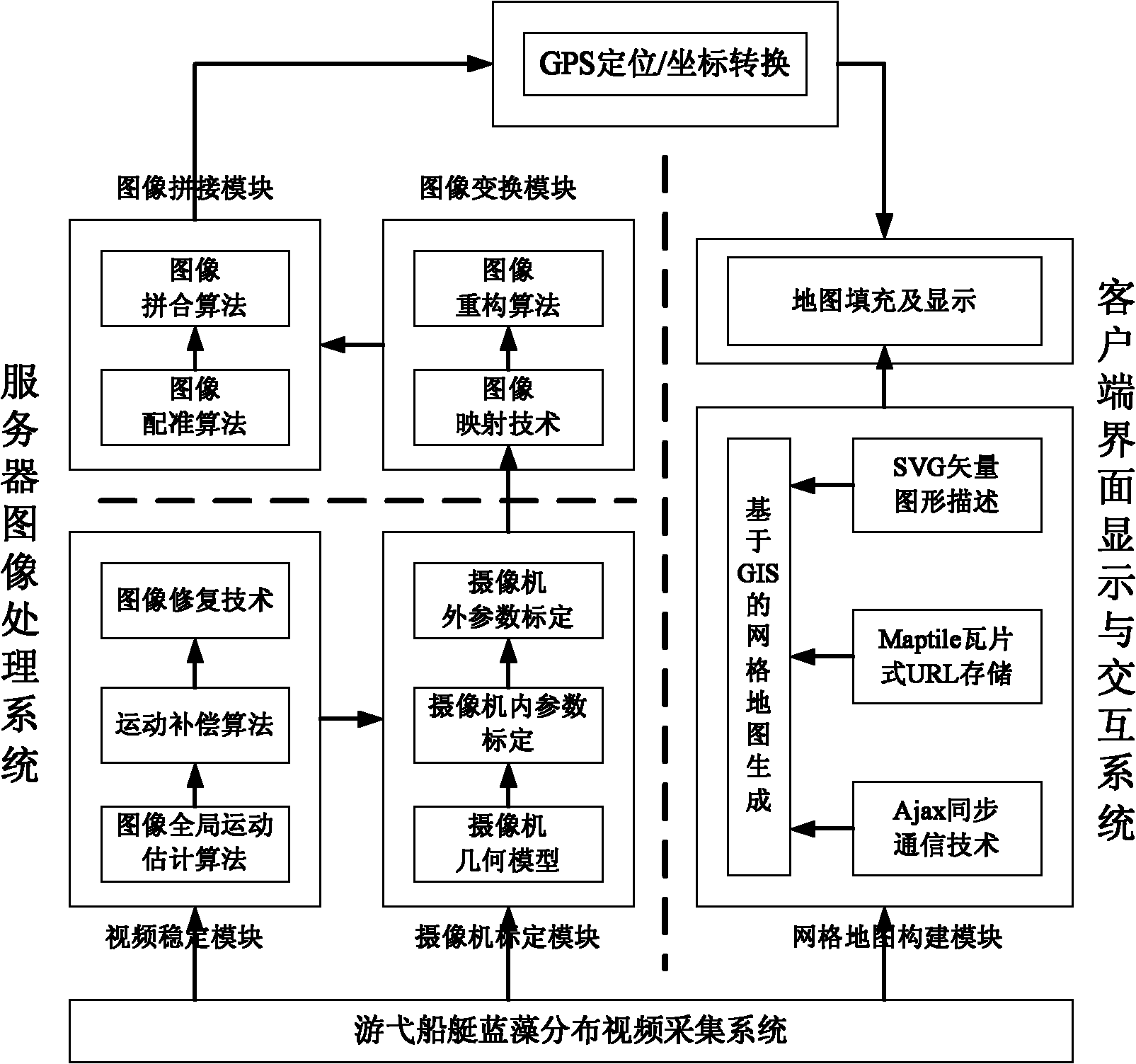
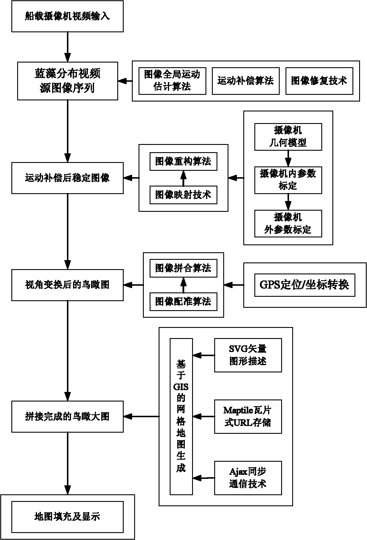
[0077] The present invention builds a bird's-eye view of the water surface based on a ship-mounted camera, which is different from a fixed camera monitoring system on land. The cruising characteristics of the image and the characteristics of the water surface image different from the land landscape determine that the system needs to adopt a special processing method. figure 1 The imaging system architecture of the present invention is shown, including a server image processing system, a client interface display and interaction system, and a cruising boat video acquisition system. The cruising boat video acquisition system includes a video acquisition device and a GPS positioning device. The video data is processed to obtain a bird's-eye view image of the water surface, and input to the client interface display and interaction system; among them: the server image processing system includes a video stabilization module, camera calibration module, image transformation module and im...


PUM


Abstract

The invention relates to a cruise image based imaging method of a water-surface aerial view, which comprises the steps of: firstly, establishing an imaging system which comprises a server image processing system, a client interface display and interactive system, and a video collecting system of a cruise boat; installing a video camera and a GPS (Global Position System) device on the boat; collecting water-surface video data; processing the video data by the server image processing system to obtain a water aerial view; and inputting the water-surface aerial view into the client interface display and interactive system. A water-surface video is collected by the cruise boat, and is converted into the water aerial view. The method has the advantages of small distortion, short period, high aging performance, low investment and good compatibility, and is disturbed by less noise.

Description

technical field [0001] The invention belongs to the field of image processing technology, and relates to image stabilization technology, camera calibration technology, image restoration technology, etc., and converts video frame images captured by patrolling boats on the water surface into bird's-eye views of the water surface to display large-area water surface conditions, such as blue-green algae, etc. , specifically a water surface bird's-eye view imaging method based on cruising images. Background technique [0002] Since the 1960s, the rapid economic development of the Taihu Basin has brought enormous pressure to the environment, resulting in serious damage to the ecosystem and a decline in environmental quality. According to the current "Surface Water Environmental Quality Standard GB3838-88", the average water quality of Taihu Lake in the mid-1990s reached Class IV, and one-third of the lake area fell into Class V, showing that the water quality has dropped by one lev...

Claims


Application Information

Patent Timeline
IPC IPC(8): G06T7/00G06T1/00G06T5/50
Inventor 李勃董蓉顾昊江登表张潇吴聪郁健刘虎陈晨陈启美
Owner NANJING UNIV
Learn More