Method for constructing geometric correction of expandable multi-satellite multi-sensor remote sensing images

A technology for geometric correction and remote sensing images, applied in the field of geometric correction of remote sensing satellite images

Inactive Publication Date: 2010-07-21
CENT FOR EARTH OBSERVATION & DIGITAL EARTH CHINESE ACADEMY OF SCI
View PDF1 Cites 9 Cited by
  • Summary
  • Abstract
  • Description
  • Claims
  • Application Information

AI Technical Summary

Problems solved by technology

[0010] The purpose of the present invention is to provide a scalable multi-satellite multi-sensor remote sensing image geometric correction construction method to solve the problem of multi-satellite multi-sensor remote sensing image geometric correction

Method used


Image

  • Method for constructing geometric correction of expandable multi-satellite multi-sensor remote sensing images
  • Method for constructing geometric correction of expandable multi-satellite multi-sensor remote sensing images
  • Method for constructing geometric correction of expandable multi-satellite multi-sensor remote sensing images

Examples


Embodiment Construction

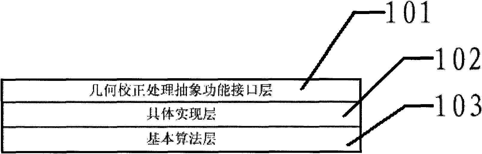
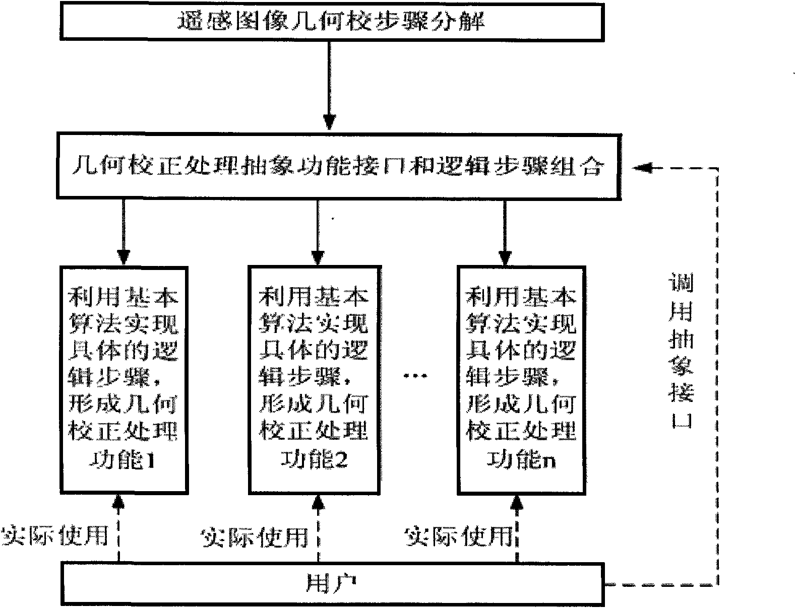
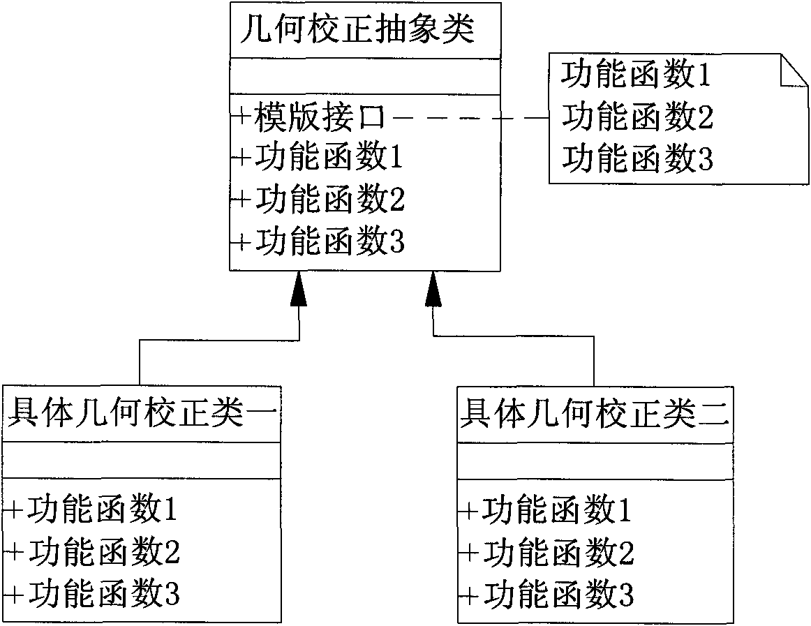
[0021] Such as Figure 1-2 As shown, the scalable multi-satellite multi-sensor remote sensing image geometric correction construction method described in the present invention includes the following steps:

[0022] 1) According to the processing flow of the geometric correction algorithm, the steps required for geometric correction of remote sensing images are divided into: image data input, output image range calculation, image correction model, pixel position transformation, resampling algorithm and corrected image output, and then in the abstract class The processing logic of the above steps is specified in the overall calling method of ;

[0023] 2) The process of the geometric correction construction method is further divided into three layers: the geometric correction processing abstract function interface layer 101, the concrete implementation layer 102 and the basic algorithm layer 103; the geometric correction processing abstract function interface layer 101 is used t...


PUM


Abstract

The invention relates to a method for constructing the geometric correction of expandable multi-satellite multi-sensor remote sensing images, which comprises the following steps: 1) according to the processing flow of a geometric correction algorithm, dividing the geometric correction of the remote sensing images into the steps of image data input, the calculation of the range of output images, image correction model, the conversion of pixel positions, a resampling algorithm and the output of correction images, and then setting the processing logic of the steps in a general invoking method of an abstract class; and 2) dividing the process of the method for constructing the geometric correction into three layers further, namely a geometric correction processing abstract function interface layer, a specific realization layer and a basic arithmetic layer; and taking satellite names or sensor identification as input parameters by users, and selecting a specific realization algorithm to be used to realize the corresponding algorithm and complete the corresponding processing function during program running. The method has the advantage that the function of the geometric correction of the multi-satellite multi-sensor remote sensing images can be processed and the required function can be expanded under the condition of no need of modifying the existing programs.

Description

technical field [0001] The invention relates to the technical field of geometric correction of remote sensing satellite images, in particular to an expandable method for constructing geometric correction of multi-satellite and multi-sensor remote sensing images. Background technique [0002] Remote sensing satellite images are distorted by factors such as the earth's rotation, atmospheric refraction, terrain fluctuations, and sensor position and attitude changes during imaging. Therefore, geometric correction and positioning must be performed on the acquired images to eliminate distortion errors and achieve accurate geocoding of images. . Among them, the establishment of the imaging geometric model, that is, the correction model, is the basis of image geometric correction and positioning, which defines the mathematical relationship between image pixel coordinates and ground space coordinates. Generally, calibration models are divided into strict imaging models and generaliz...

Claims


Application Information

Patent Timeline
Patent Type & Authority Applications(China)
IPC IPC(8): G06T1/00G06T7/40
Inventor 李景山刘定生
Owner CENT FOR EARTH OBSERVATION & DIGITAL EARTH CHINESE ACADEMY OF SCI
Why Eureka
Try Eureka