
Gravel pit earth volume measuring method based on digital image technology

A technology of digital image and earthwork quantity, which is applied to the measurement of earthwork quantity in sand and gravel pits. The field of earthwork quantity measurement in sand and gravel pits based on digital image technology can solve the problems of incomplete and inaccurate data collection, and achieve simple equipment and improved measurement. Accuracy, the effect of reducing the number of layouts

Inactive Publication Date: 2010-06-23
SOUTHEAST UNIV
View PDF0 Cites 17 Cited by
  • Summary
  • Abstract
  • Description
  • Claims
  • Application Information

AI Technical Summary

Problems solved by technology

However, this kind of field measurement will have incomplete and inaccurate data collection, such as terrain changes such as ditches, ridges, dikes, slopes, etc. There are no points or few points below, and they will also be affected by weather and environment

Method used


Image

  • Gravel pit earth volume measuring method based on digital image technology
  • Gravel pit earth volume measuring method based on digital image technology
  • Gravel pit earth volume measuring method based on digital image technology

Examples


Embodiment Construction

[0033] The specific embodiments of the present invention will be further described below in conjunction with the accompanying drawings.

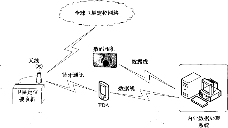
[0034] Such as figure 1 , the method of earthwork measurement based on close-range photogrammetry technology has

[0035] (1) GNSS network for global satellite positioning;

[0036] (2) Field data acquisition system: a handheld computer with an operating system of Windows Mobile 5.0 and above and field data acquisition software installed, a digital camera, and a set of GPS / RTK equipment;

[0037] Office data processing system: a computer with .NetFramework 2.0 installed with the office data processing system.

[0038]Before field measurement, configure the parameters and network connection of the handheld computer deployed with field data acquisition software; when performing field measurement, set up control points, run the field software on the handheld computer, and receive data in real time through the GNSS network The GPS positioning...


PUM


Abstract

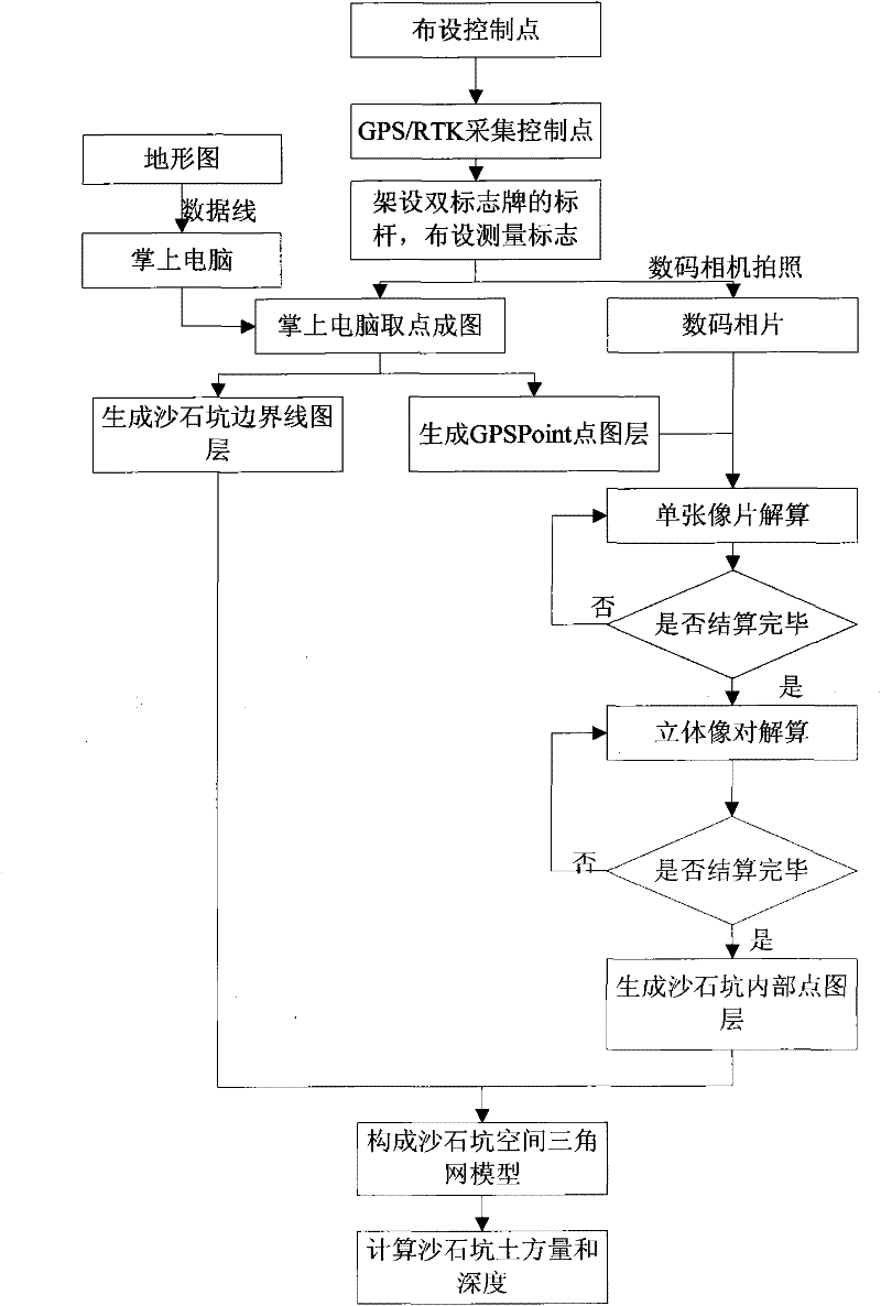
A gravel pit earth volume measuring method based on digital image technology adopts a palm computer, a GPS receiver and a digital camera to realize the digital acquisition and recording of field information. During field measurement, the GPS receiver distributes control points and collects the three-dimensional coordinates of the control points; the software running on the palm computer receives GPS positioning results in real-time through the GNSS network and generates a GPSPoint point coverage and gravel pit boundary coverage; a proper control is selected to erect a marker post, two signboards are arranged on the marker post and used as the photo control points, the digital camera is adopted to take photos of the gravel pit and the marker post; when the field operation is over, the photos and the field acquisition data are uploaded to an interior work data processing system; according to the control point coverage, a single photo is utilized to resolve the photo information, and then the three-dimensional coordinates of the internal point of the gravel pit are obtained through three-dimensional relative calculation; a triangular network model of the gravel pit is constructed and is calculated to obtain the depth and earth volume of the gravel pit.

Description

technical field [0001] The invention relates to a method for measuring the earth volume of a sandstone pit, in particular to a method for measuring the earthwork volume of a sandstone pit based on digital image technology, and belongs to the technical field of land management electronic information. Background technique [0002] With the acceleration of the country's urbanization and the development of various construction projects, the speed of sand and gravel mining in my country has gradually accelerated, but most of them are small and medium-sized. From the mid-to-late 1990s to the beginning of this century, with the acceleration of my country's urbanization process, especially the rapid development of infrastructure construction such as real estate and roads, large, medium and small cities have a huge market demand for sand and gravel. The phenomenon of sand mining continues to intensify, reaching a state of out-of-control for a time, and the characteristics of corporati...

Claims


Application Information

Patent Timeline
Patent Type & Authority Applications(China)
IPC IPC(8): G01B11/00G01B11/03G01C11/00
Inventor 王庆王慧青沙月进张玉珠胡璇
Owner SOUTHEAST UNIV
Learn More