
Freeway network vehicle track identification system and method based on mobile positioning technology

A mobile positioning and high-speed road network technology, applied in positioning, radio wave measurement systems, measurement devices, etc., can solve the problems of delaying the arrival of rescue personnel at the scene, inability to accurately describe the location, and low frequency of use. The effect of speeding on the expressway and solving the problem of ambiguous path recognition

Inactive Publication Date: 2010-02-10
View PDF0 Cites 36 Cited by
  • Summary
  • Abstract
  • Description
  • Claims
  • Application Information

AI Technical Summary

Problems solved by technology

The installation of fixed emergency telephones is separated by distance, the frequency of use is low, and the construction and maintenance costs are high; although dialing the special service number for help can report the situation on the spot in time, for most help-seekers, it is impossible to accurately describe the location. Especially in bad weather conditions, delaying the arrival of rescuers on the scene

Method used

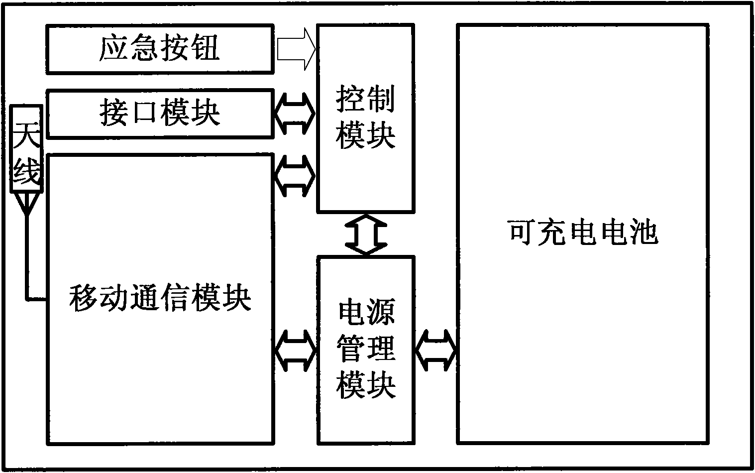

Image

  • Freeway network vehicle track identification system and method based on mobile positioning technology
  • Freeway network vehicle track identification system and method based on mobile positioning technology

Examples


Embodiment 1

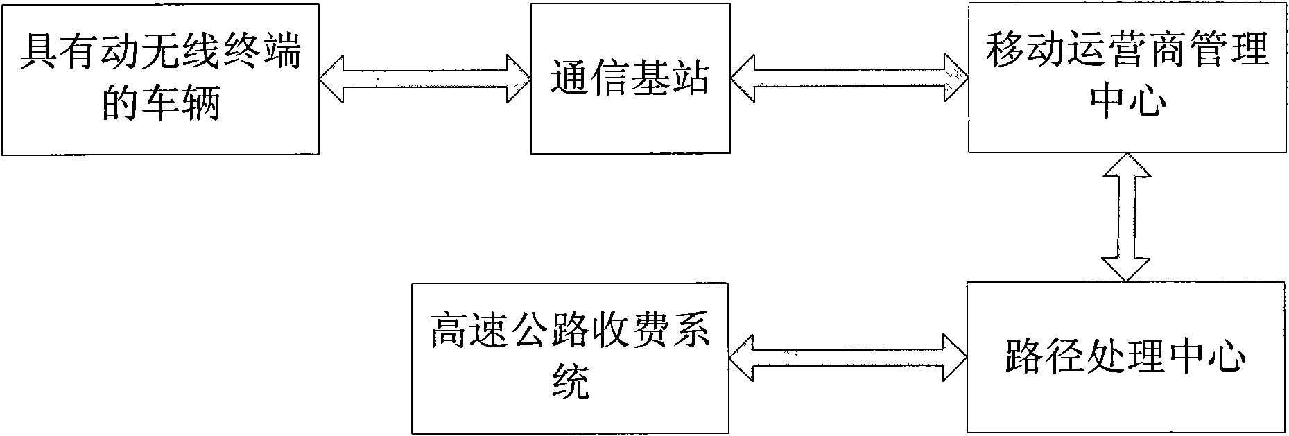
[0015] The vehicle trajectory recognition system and method in the expressway network based on mobile positioning technology, including a vehicle-mounted mobile wireless terminal or a mobile wireless terminal arranged on a pass card distributed to the vehicle, the mobile wireless terminal is a mobile communication terminal (i.e. a mobile phone) or has The mobile phone chip with mobile phone communication function, the mobile wireless terminal identification system used to identify whether the vehicle carries a mobile wireless terminal, the mobile operator management center connected with the mobile wireless terminal through wireless communication, and the path processing center connected with the mobile operator management center .

[0016] Set the mobile wireless terminal on the vehicle or distribute the access card equipped with the mobile wireless terminal to the vehicle, and use the mobile wireless terminal identification system to identify and confirm the mobile wireless t...

Embodiment 2

[0018] This embodiment is a method for monitoring the driving path of a high-speed vehicle based on mobile positioning technology. The method includes the following steps:

[0019] (1) At the intersection of entering the expressway network, a mobile wireless terminal is established on the vehicle entering the expressway network, and the mobile wireless terminal is connected with the mobile operator management center for wireless communication; the mobile wireless terminal described here is a vehicle-mounted mobile wireless terminal Or the mobile wireless terminal set on the pass card distributed to the vehicle, the mobile wireless terminal is a mobile phone communication terminal (i.e. a mobile phone) or a mobile phone chip with a mobile phone communication function;

[0020] (2) Steps of activating the mobile wireless terminal before the vehicle enters the expressway entrance, and using the mobile wireless terminal identification system to identify and confirm the mobile wirel...


PUM


Abstract

The invention discloses a freeway network vehicle track identification system and a method based on mobile positioning technology. A monitoring system comprises a vehicle-mounted mobile wireless terminal or a mobile wireless terminal arranged on a password card distributed to vehicles, a mobile operator management center in wireless communication connection with the wireless terminal, and a path processing center connected with the mobile operator management center. The freeway network vehicle track identification system and the method based on mobile positioning technology of the invention utilize mature base station positioning technology based on the mobile network to realize the whole course track monitoring of driving vehicles on freeways, provide technology basis for vehicle overspeed, track abnormality and the like and provide position information support for emergency rescue; thus, the aim of effectively inhibiting overspeed, toll fee evasion and fraud and the like can be realized, and the ambiguity path identification problem of the freeway network vehicle driving can be solved.

Description

technical field [0001] The invention relates to a vehicle track recognition system and method in a highway network based on mobile positioning technology. Background technique [0002] With the development of expressways in our country and the rapid increase of car ownership, the number of incidents such as toll evasion, traffic accidents, and vehicle failures on expressways is increasing. [0003] With the continuous development of expressways in our country, a large-scale and complex expressway traffic network has been formed, and most provinces and cities have realized intra-provincial toll collection. At present, most expressways use networked semi-automatic toll collection. , that is, the method of "manual toll collection, computer management, and closed-circuit television monitoring". This method only uses the toll card as the vehicle toll voucher, and only pays attention to the entry and exit of road network vehicles, and lacks effective means of vehicle trajectory mo...

Claims


Application Information

Patent Timeline
IPC IPC(8): G08G1/01G01S5/02G07B15/00
Inventor 严皓任佳
Learn More