Locomotive wheel diameter automatic calibration system and method based on satellite positioning
A satellite positioning and automatic calibration technology, applied in automatic systems, beacon systems using radio waves, positioning and other directions, can solve the problems of large human influence, large errors, large construction and maintenance costs, etc., to reduce train positioning errors, Guaranteed safe effect
- Summary
- Abstract
- Description
- Claims
- Application Information
AI Technical Summary
Problems solved by technology
Method used
Image
Examples
Embodiment 1
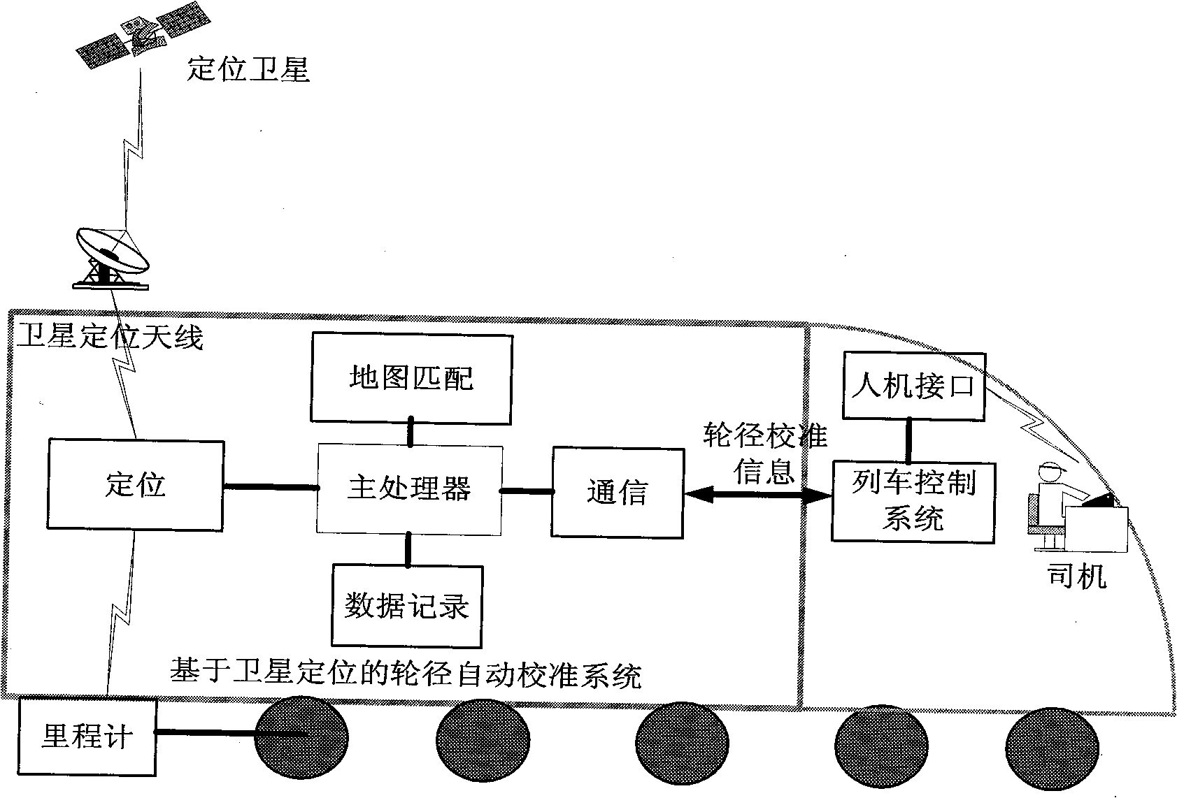
[0027] Example 1 as figure 2 As shown, the locomotive wheel diameter automatic calibration system based on satellite positioning includes a main processor, a positioning module, a map matching module, a data recording module, a communication module and a map database. During the operation of the train, the positioning module receives the position information of the train through the satellite positioning receiver, calculates the position information to obtain the current latitude and longitude information of the locomotive, and converts it into geodetic coordinate information according to actual needs. The positioning information is matched with the map through the map matching module, and the main processor reads the digital map from the map database, and searches for matching points corresponding to the positioning coordinates on the digital map to obtain the position of the train on the map. The main processor obtains the wheel diameter calibration information through rele...
Embodiment 2
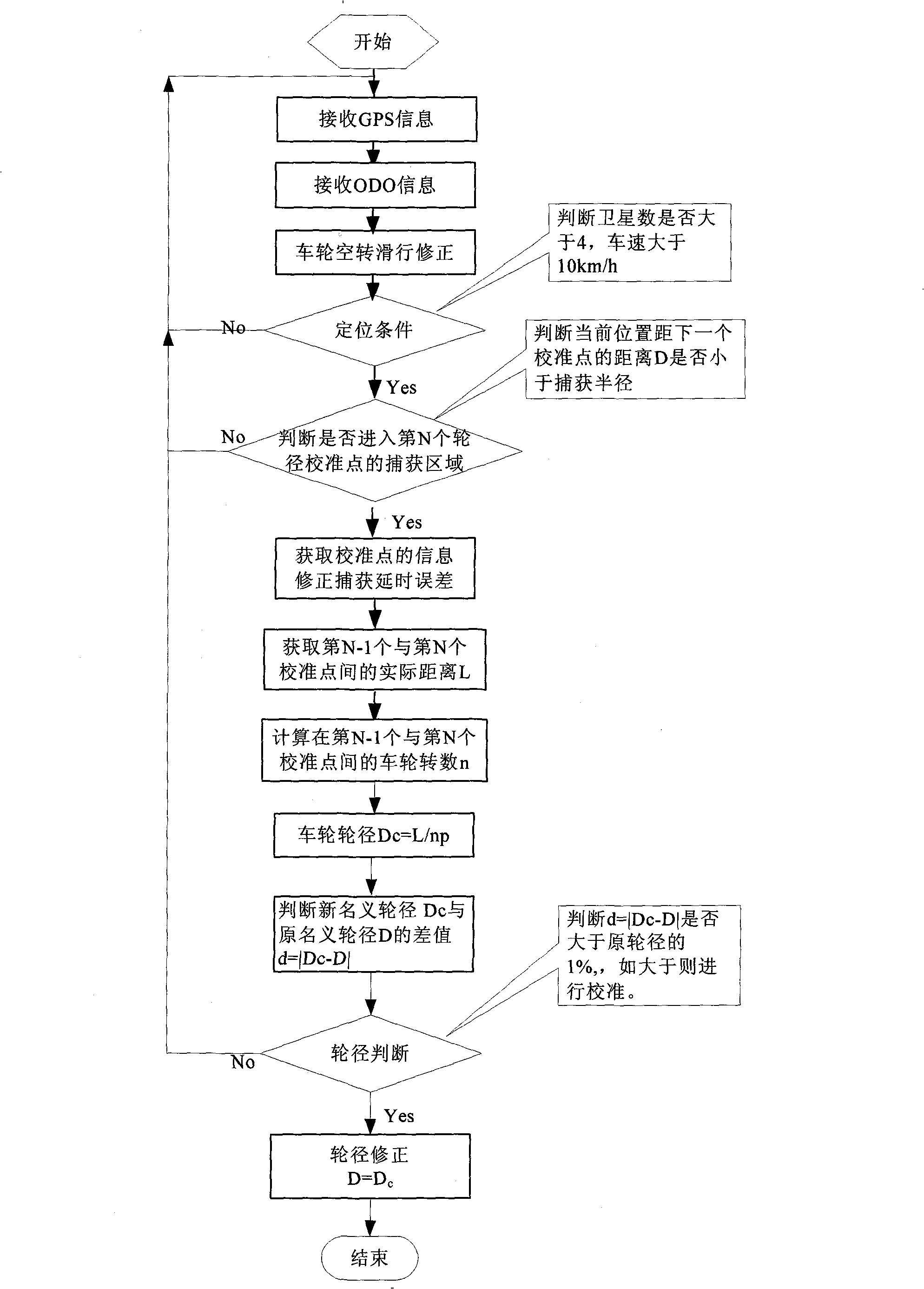
[0028] Example 2 image 3 It is a flow chart of the method for automatically calibrating the wheel diameter of a locomotive based on satellite positioning according to the present invention. The locomotive wheel diameter automatic calibration method based on satellite positioning comprises the following steps: first, determine the position of the wheel diameter calibration key point, set up the map database of the wheel diameter calibration key point, in this embodiment the establishment of the map database can be established manually or through Satellite positioning is automatically established; then, by detecting the number of wheel rotations of the train passing between two calibration points, the actual distance between two key points, and combining satellite positioning to determine whether the train has reached the key point of wheel diameter calibration, thereby realizing wheel diameter calibration . In this example, if image 3 As shown, the specific process steps to...
Embodiment 3
[0035] Embodiment 3 In the above step 1, the mileage information sent by the odometer is synchronized with the satellite positioning information. Figure 4 It is a schematic diagram of the method for synchronizing satellite positioning information and odometer information according to the present invention. As shown in the figure, after the system is initialized, start the counter; the output of the odometer is a pulse signal, and the output frequency of the satellite positioning receiver is per second Once, so consider counting the pulse signal of the odometer in units of 1 second. When counting, the 1pps signal sent by the satellite positioning receiver is used as the reference, and the number of pulses between the arrival of the two 1pps signals is recorded to obtain the operation of the train. Speed; when the 1pps signal comes, extract the value in the counter, and restart counting after clearing the counter to realize the synchronization function.
PUM
 Abstract
Description
Claims
Application Information
 - Generate Ideas
- Intellectual Property
- Life Sciences
- Materials
- Tech Scout
- Unparalleled Data Quality
- Higher Quality Content
- 60% Fewer Hallucinations
Browse by: Latest US Patents, China's latest patents, Technical Efficacy Thesaurus, Application Domain, Technology Topic, Popular Technical Reports.
© 2025 PatSnap. All rights reserved.Legal|Privacy policy|Modern Slavery Act Transparency Statement|Sitemap|About US| Contact US: help@patsnap.com


