Eureka AIR delivers breakthrough ideas for toughest innovation challenges, trusted by R&D personnel around the world.

Spatially integrated aerial photography for bridge, structure, and environmental monitoring

a technology for aerial photography and bridges, applied in the field of data processing, can solve the problems of high deterioration rate, scarcity of maintenance and new construction funding, and the bridges in the united states are facing a crisis, so as to facilitate spatial integration and automatic damage detection

Active Publication Date: 2015-04-21
THE UNIV OF NORTH CAROLINA AT CHAPEL HILL
View PDF20 Cites 36 Cited by
  • Summary
  • Abstract
  • Description
  • Claims
  • Application Information

AI Technical Summary

Benefits of technology

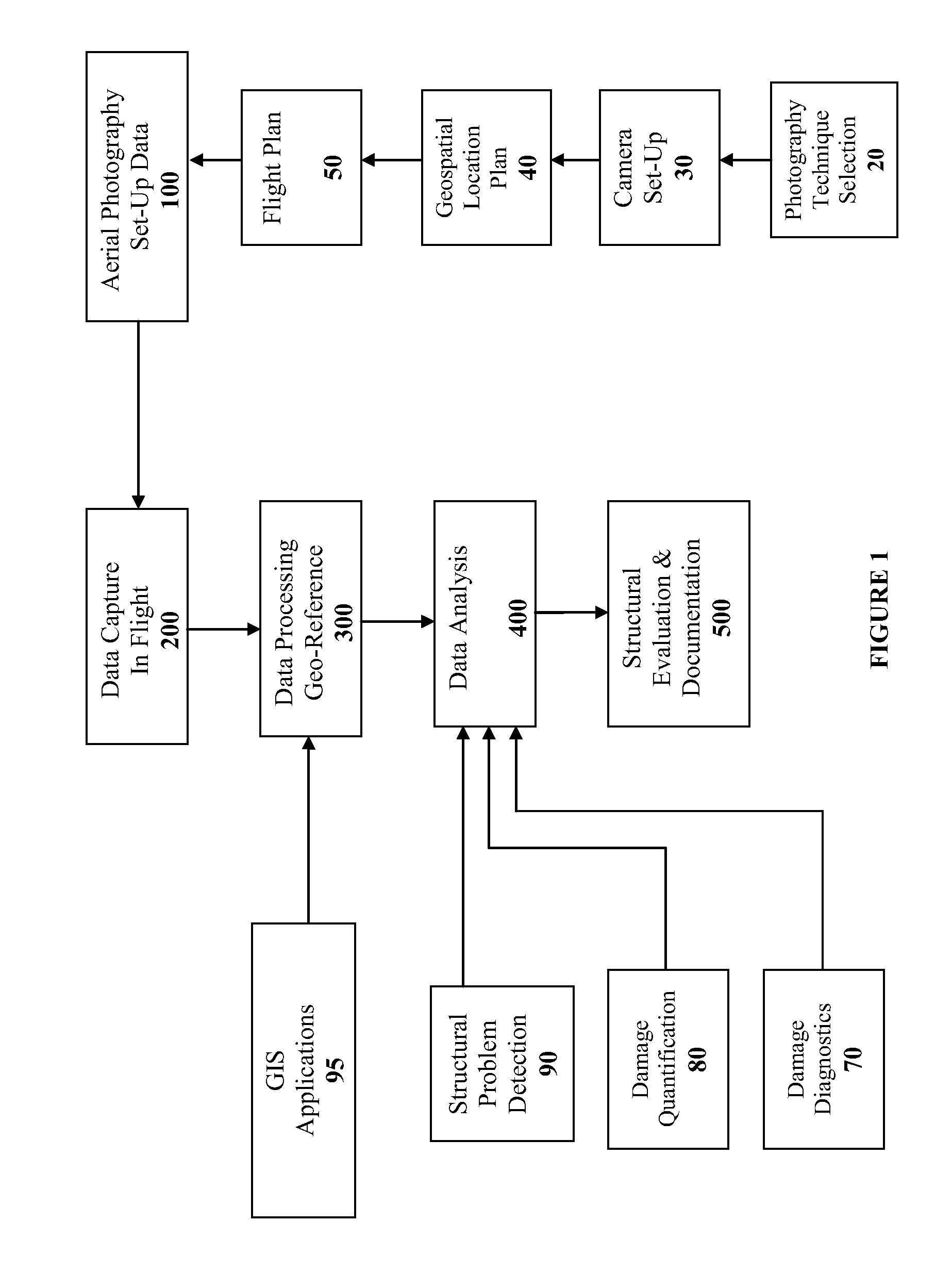
The present invention proposes a low-cost solution for remote bridge inspection using small-format aerial photography. This technique can provide top-down views of sub-inch cracks and joint openings on bridge decks or highway pavements. An Onboard Global Positioning System geo-references the images collected, facilitating spatial integration and automated damage detection. A deck condition rating technique based on large crack detection is used to quantify the condition of the existing bridge decks. Overall, this invention offers a cost-effective and efficient means for inspecting bridges and highways.

Problems solved by technology

Bridges in the United States are facing a crisis of high deterioration rates coupled with a scarcity of maintenance and new construction funding.
The report stated that more than a quarter of all bridges are considered either structurally deficient or functionally obsolete.
With the increasing investment needs for national infrastructure improvement, the HTF is facing the problem of a financial deficit.
Furthermore, visual-based inspections tend to be time consuming as the inspector must visit the bridge site, assemble photographic and text-based information, and make a determination regarding the integrity of the structure.
All of these techniques, however, are localized, labor intensive, and relatively expensive.
Due to the sheer size of most bridge structures, however, these SHM techniques may be cost prohibitive.
CRS-SI applications to structural health monitoring have been extremely limited, however.
Among the factors contributing to the limited use of such technologies are lack of guidelines for the use of CRS-SI technologies for bridge management, limited experience with the technology among bridge managers, and difficulties in integrating different kinds of inspection data into a manageable form.

Method used


Image

  • Spatially integrated aerial photography for bridge, structure, and environmental monitoring
  • Spatially integrated aerial photography for bridge, structure, and environmental monitoring
  • Spatially integrated aerial photography for bridge, structure, and environmental monitoring

Examples


Embodiment Construction

[0021]The present invention now will be described more fully hereinafter in the following detailed description of the invention, in which some, but not all embodiments of the invention are described. Indeed, this invention may be embodied in many different forms and should not be construed as limited to the embodiments set forth herein; rather, these embodiments are provided so that this disclosure will satisfy applicable legal requirements.

[0022]The terminology used herein is for the purpose of describing particular embodiments only and is not intended to be limiting of the invention. As used herein, the term “and / or” includes any and all combinations of one or more of the associated listed items. As used herein, the singular forms “a,”“an,” and “the” are intended to include the plural forms as well as the singular forms, unless the context clearly indicates otherwise. It will be further understood that the terms “comprises” and / or “comprising,” when used in this specification, spe...


PUM


Abstract

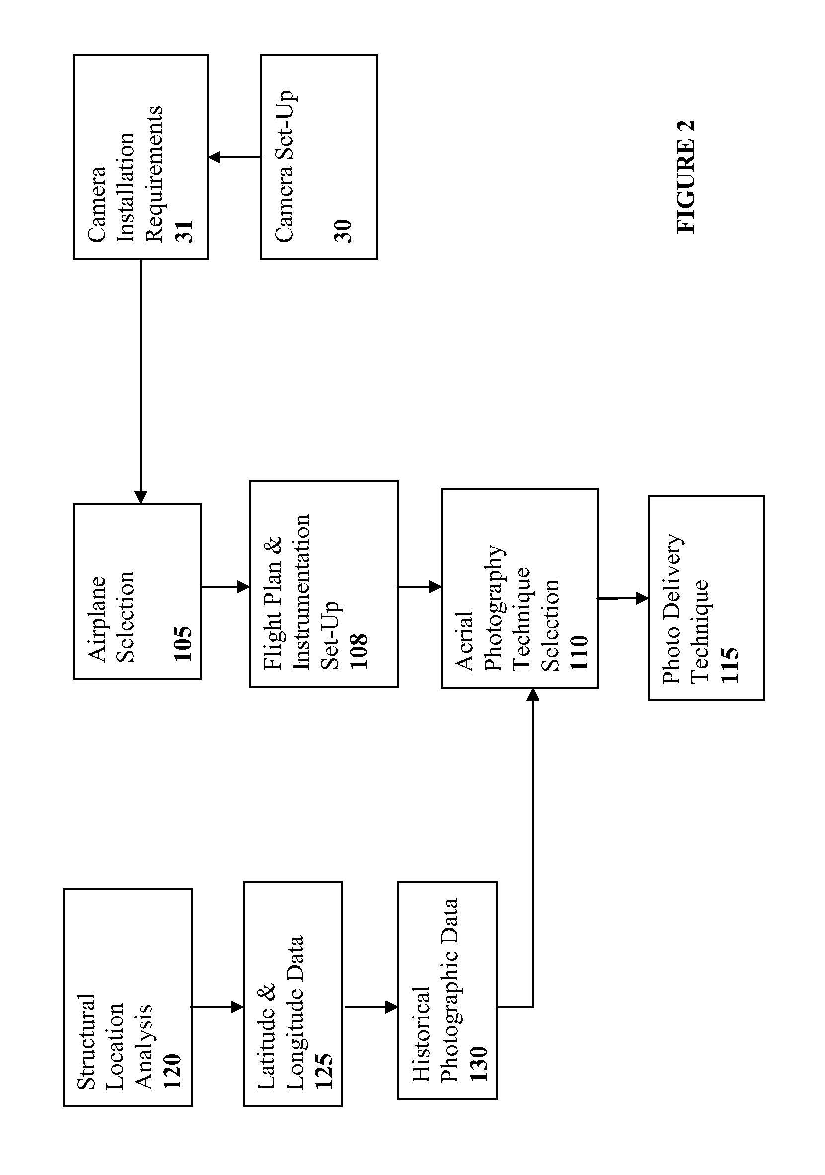
Spatially Integrated Small-Format Aerial Photography (SFAP) is one aspect of the present invention. It is a low-cost solution for bridge surface imaging and is proposed as a remote bridge inspection technique to supplement current bridge visual inspection. Providing top-down views, the airplanes flying at about 1000 feet can allow visualization of sub-inch (large) cracks and joint openings on bridge decks or highway pavements. On board Global Positioning System (GPS) is used to help geo-reference images collected and allow automated damage detection. A deck condition rating technique based on large crack detection is used to quantify the condition of the existing bridge decks.

Description

CROSS-REFERENCE TO RELATED APPLICATIONS[0001]This application claims priority to U.S. Provisional Patent Application No. 61 / 326,828, filed Apr. 22, 2010, which is hereby incorporated by reference herein in its entirety.GOVERNMENT SUPPORT[0002]This invention was made with Government support under award number DTOS59-07-H-0005 from the United States Department of Transportation (USDOT). The Government has certain rights in the invention.FIELD OF THE INVENTION[0003]The invention relates generally to data processing. More specifically, the invention relates to data processing involving the monitoring of highway and railroad bridges and other structures.BACKGROUND[0004]A nation's transportation infrastructure is crucial to its economic growth and public safety. The function and condition of roads, rails, and ports determine the efficiency of commerce. Bridges are part of the critical transportation infrastructure that can be considered the backbone of a nation's healthy economy. The cond...

Claims


Application Information

Patent Timeline
Patent Type & Authority Patents(United States)
IPC IPC(8): G06K9/00G06T7/00
CPCG06T7/0002G06T2207/10024G06T2207/10032G06T2207/30184
Inventor CHEN, SHEN-ENHAUSER, EDWIN W.BOYLE, CHARLES G.
Owner THE UNIV OF NORTH CAROLINA AT CHAPEL HILL
Why Eureka
Eureka Blog
Learn More