
Reverse geocoding system using combined street segment and point datasets

a street segment and point dataset technology, applied in traffic control systems, navigation instruments, instruments, etc., can solve the problems of fewer high-accuracy address matches and not comprehensive geographic coverage, and achieve the effect of increasing the overall system accuracy

Active Publication Date: 2010-02-23
PRECISELY SOFTWARE INC
View PDF3 Cites 22 Cited by
  • Summary
  • Abstract
  • Description
  • Claims
  • Application Information

AI Technical Summary

Benefits of technology

"The present invention provides a system and method for combining centerline and point level datasets for reverse geocoding purposes. The system analyzes the geometrical relationships of street segments and points in datasets containing both street segment and point data to determine an address for a particular location. The system can match to the most accurate nearby address or intersection based on the geometric relationships of the combined street networks and individual locations. The system employs the spatial relationships of street segment networks and point locations to select matches to slightly farther points over interpolated street segment locations to increase accuracy. The technical effect of the invention is to provide a more accurate and efficient system for reverse geocoding."

Problems solved by technology

However, point datasets require that a large amount of data be stored and searched to find an address for the input longitude and latitude and they do not contain intersection points.
Point datasets, consisting of parcel or improvement centroids for specific addresses are now available, but these are not comprehensive in their geographic coverage.
This strict matching results in fewer high accuracy address matches being made.

Method used


Image

  • Reverse geocoding system using combined street segment and point datasets
  • Reverse geocoding system using combined street segment and point datasets
  • Reverse geocoding system using combined street segment and point datasets

Examples


Embodiment Construction

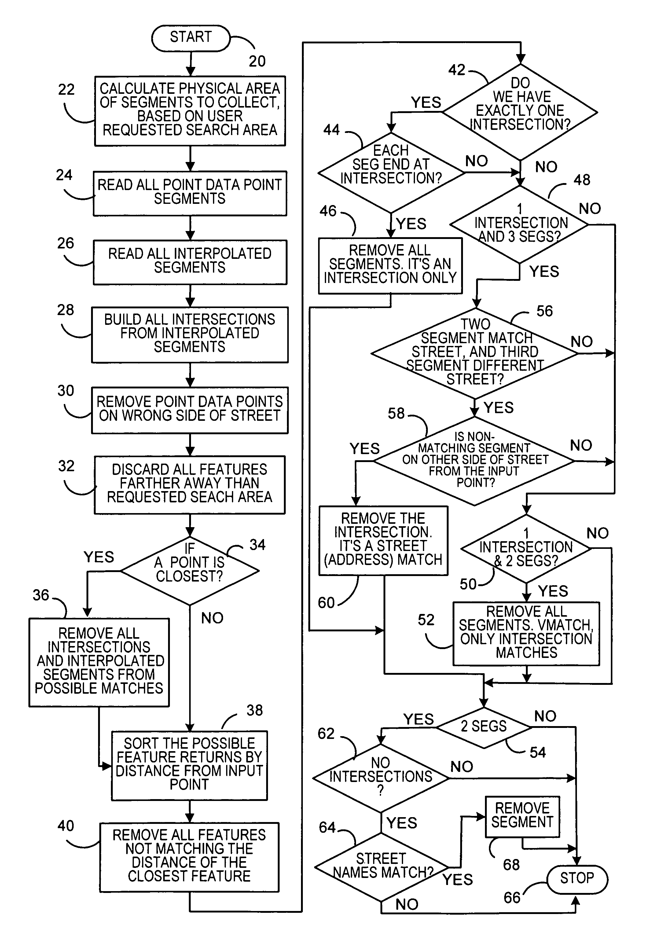
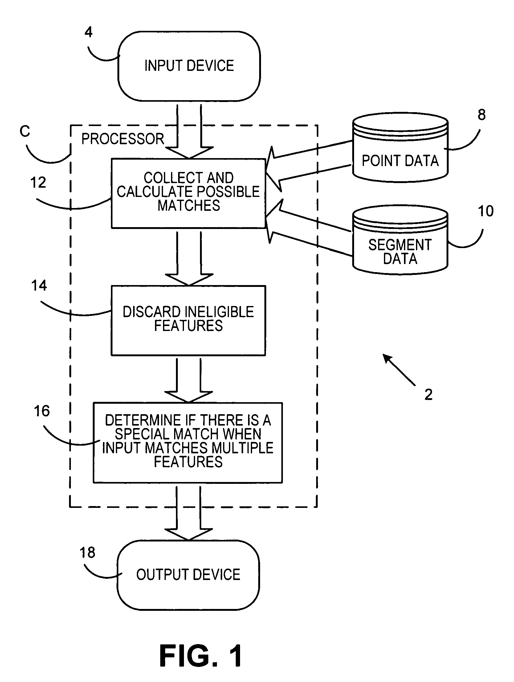
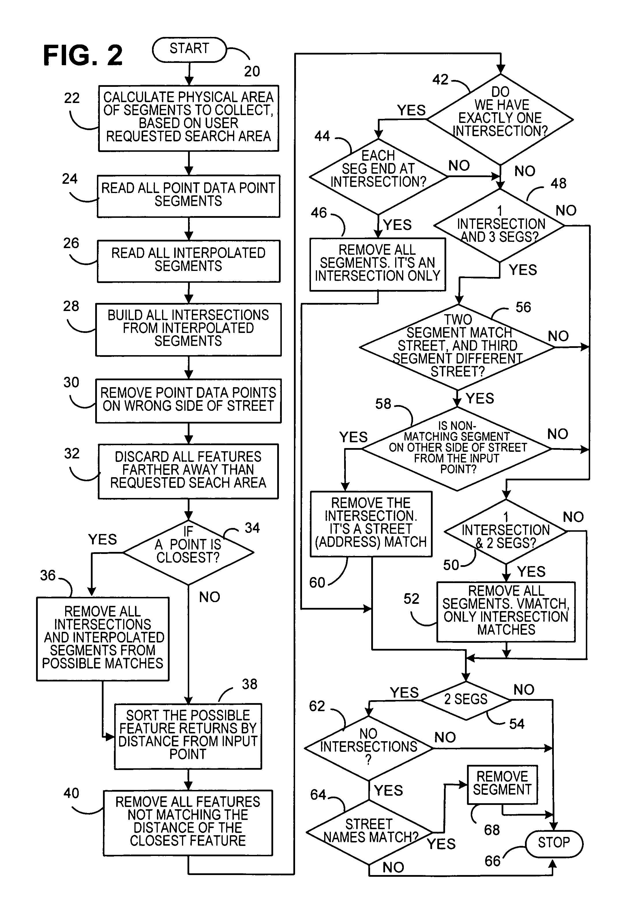
[0026]Reference is now made to FIG. 1. A reverse geocoding system 2 includes an input device 4. The input device 4 can be, for example, a keyboard or other input system. The input can also be from another module in a larger system that requires information from the reverse geocoding system 2. The input device 4 is connected to a processor 6. The processor 6 is connected to operate in conjunction with a database 8 containing point data and a database 10 containing street segment data. The processor 6 contains a program store which causes the processor 6 to process information from both the database 8 and the database 10 and operate in the manner shown in FIG. 2. This is based on input data from the input device 4 of the latitude and longitude of an input point to be processed, along with a maximum search distance in all directions to be used to find a specific feature through the reverse geocoding system 2 and a squeeze distance. The squeeze distance is an offset from the ends of eac...


PUM


Abstract

A reverse geocoding system and method processes a point level dataset and a street segment dataset to determine an address for a particular latitude and longitude of an input point entered into the system. A determination is made if the point level dataset contains a point level data address match to the entered latitude and longitude data within the closest street segment and without crossing the street segment. Any such point level data address match is output. When no such point level data address match is made, the system computes an interpolated address from a range of addresses of the closest street segment in the street segment dataset based on the entered latitude and longitude of the input point in relation to said range of addresses for the closest street segment. The interpolated address from the closest street segment in the street segment dataset is output. The street segment dataset may also contain unranged street segments without ranges of addresses.

Description

FIELD OF THE INVENTION[0001]The present invention relates to reverse geocoding systems and more particularly to a reverse geocoding system employing point level and street segment datasets.BACKGROUND OF THE INVENTION[0002]Reverse geocoding systems return an address based on the closest georeferenced data item in a dataset to an input physical location, usually the latitude and longitude of the physical location. These datasets are generally comprised of street segment centerlines, each attributed with ranges of addresses, or single-parcel polygons that contain one street address attribute for each polygon. Individual addresses are calculated from the street segments by interpolation. Addresses are computed in parcel datasets using standard point-in-polygon processes. Street intersections are derived from street segments that abut or cross. Point or parcel datasets, hereinafter referred to as point datasets or point level datasets, are known to give more accurate results than street ...

Claims


Application Information

Patent Timeline
Patent Type & Authority Patents(United States)
IPC IPC(8): G01C21/30
CPCG06F17/30241G06F16/29
Inventor SEARIGHT, KEITH R.LOGAN, DAVID J.BOURLAND, II, FREDDIE J.LOHER, CATHERINE J.CHARLTON, BERKLEY R.
Owner PRECISELY SOFTWARE INC
Learn More