
Digital map data processing system

a data processing system and digital map technology, applied in the field of digital map data processing system, can solve the problems of damage to manual adjustment of such awkward display, and the display of road polygons of certain geometry, so as to improve the appearance of the resulting map and achieve the effect of high potential

Inactive Publication Date: 2009-03-24
ZENRIN
View PDF9 Cites 4 Cited by
  • Summary
  • Abstract
  • Description
  • Claims
  • Application Information

AI Technical Summary

Benefits of technology

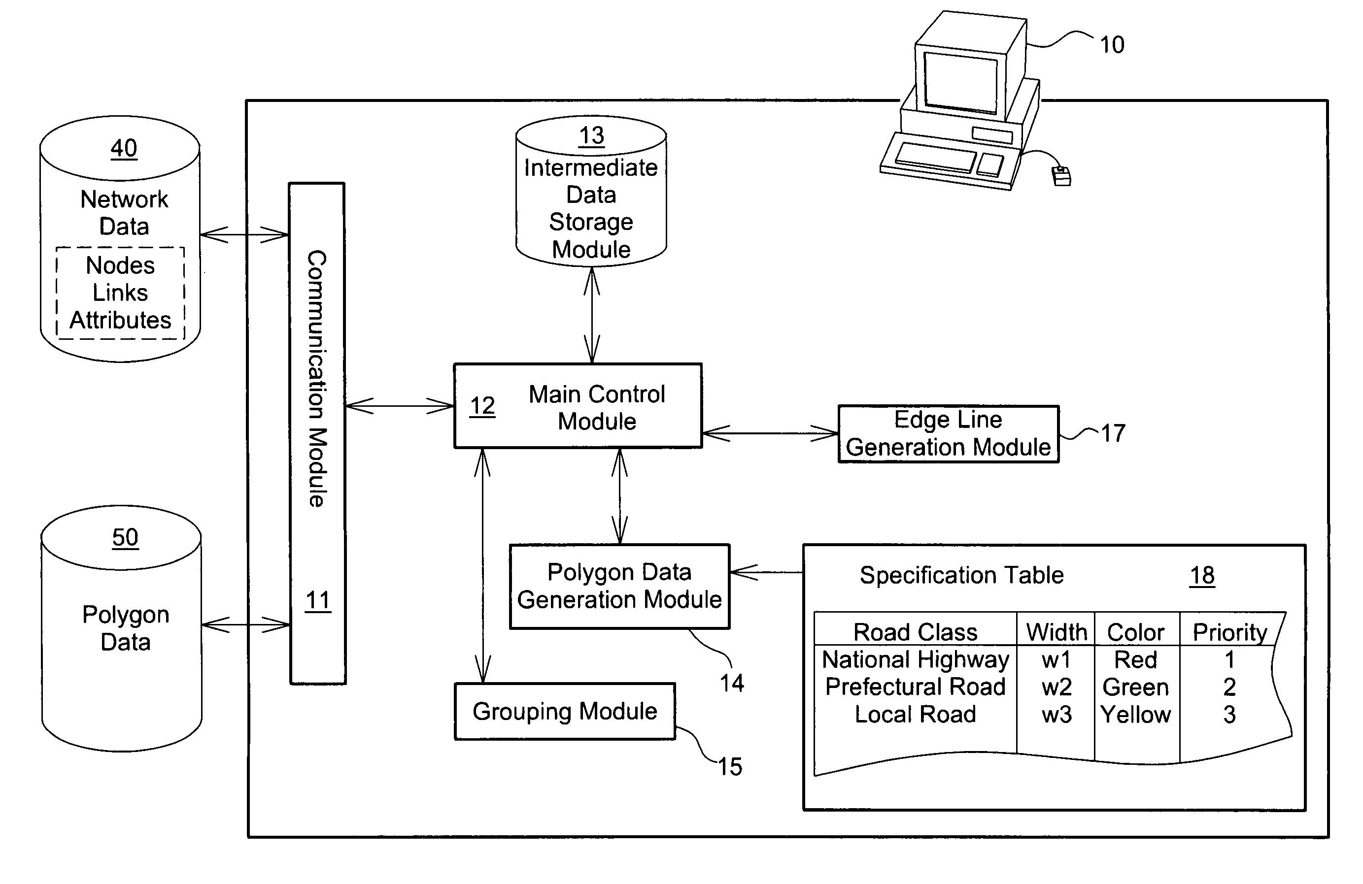
[0009]The digital map data processing system of the invention takes into account the attributes or other factors of each connection road and applies the optimum processing technique to specify the terminal geometry of the object road for smooth connection with the connection road. The selective use of the multiple terminal processing techniques desirably reduces the awkwardness in display of map drawing. The arrangement of the invention requires relatively light load for generation of road polygons with less awkwardness in display of map drawing.
[0025]Adjustment of the terminal geometry at a connection of adjacent polygons may be required for the improved appearance of a map. A preferable procedure of the terminal geometry adjustment selects a suitable processing technique among multiple options, in response to a requirement for the adjustment, based on at least part of the attributes, geometry, and directions of an object road as a processing target and a connection road to be connected with the object road. The selection of the processing technique may be based on whether the connection road and the object road are set in one identical group or whether some of the connection road polygons are set in one identical group. This arrangement ensures the continuity of geometry for adjacent polygons to be regarded as a continuous road.

Problems solved by technology

The conventional color code technique may, however, cause some awkwardness in display of road polygons of certain geometry at an intersection between a national highway and a prefectural road.
This damages the appearance of a resulting map.
The operator's manual adjustment of such awkward display for the improved map appearance undesirably requires the heavy load for generation of map data.
Such elimination of the edge lines is manually specified by the operator and thus requires the extremely heavy load.

Method used


Image

  • Digital map data processing system
  • Digital map data processing system
  • Digital map data processing system

Examples


case 4

[0159]In Case 4, multiple connection roads at an intersection are the mixture of those in the same road class as and those in a different road class from the object road, and the object road has non-continuity with any connection road. In this case, the polygon convex process is performed individually for the respective roads.

[0160]This modified example executes the polygon terminal processing for three or more roads and accordingly has some difference in the polygon convex process from that of the embodiment (see FIG. 9). The polygon convex process of the modified example is described briefly with reference to the flowchart of FIG. 9. The polygon convex process of the modified example specifies the continuity or non-continuity of connection roads (step S120A) after convexing the terminal geometry of the polygon of the object road (step S120). While the connection status in Case 4 (see FIG. 17) specifies the continuity or non-continuity of an object road with a connection road, the ...


PUM


Abstract

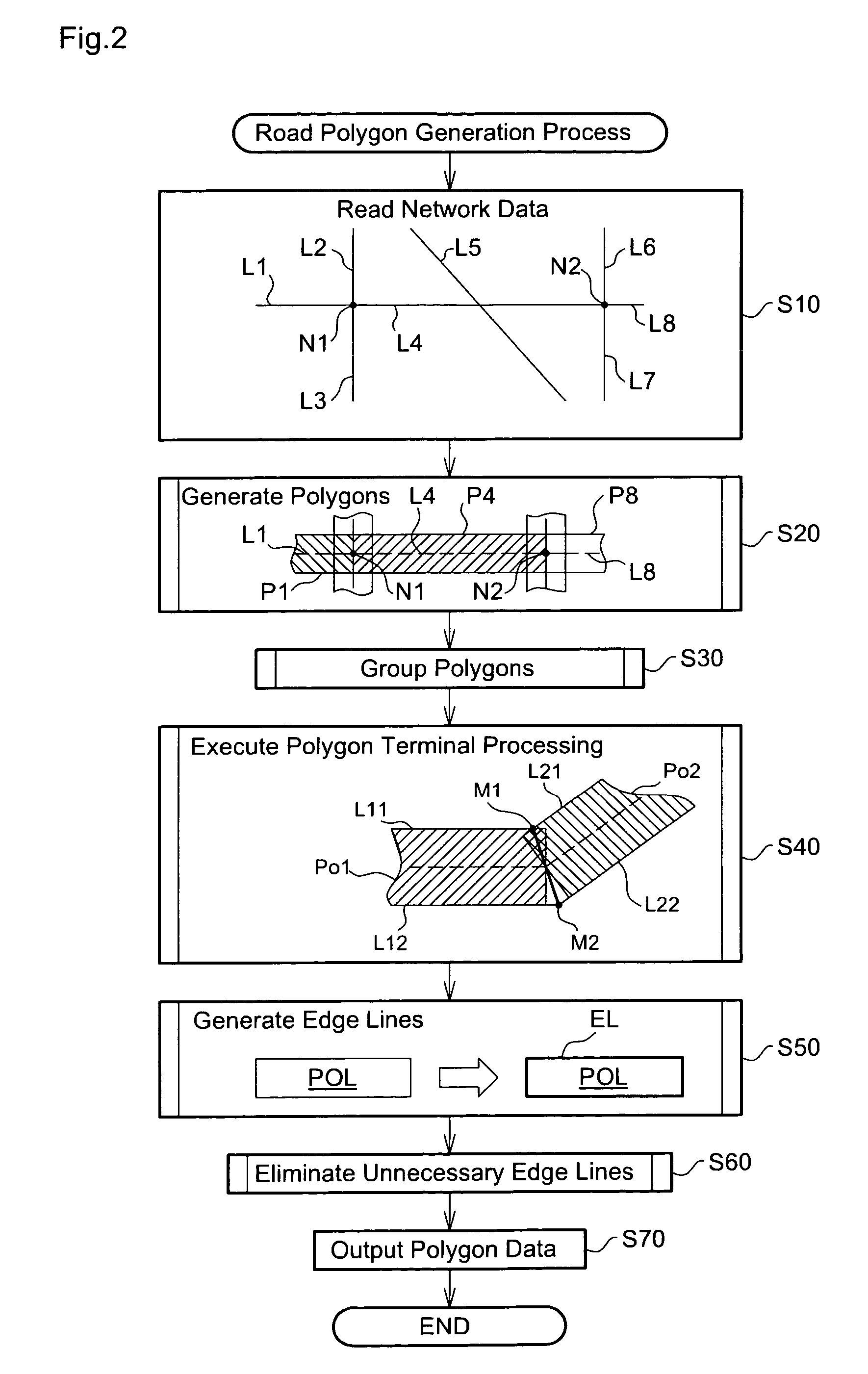
A digital map data processing system is described that improves the appearance of a map without increasing the labor in automatic generation of road polygons required for generation of map data. The digital map data processing system reads network data, which expresses multiple roads by nodes and links, and generates polygon data including road polygons by processing the network data. The road polygon generation process includes generation of rectangular polygons of specified widths about respective links, generation of edge lines around polygons, and elimination of unnecessary edge lines. The digital map data processing system selectively applies a suitable terminal processing technique to specify terminal geometry of each object polygon, based on connection with each connection polygon and geometries and attributes of the object polygon and the connection polygon. This desirably improves the appearance at a connection of adjacent polygons.

Description

BACKGROUND OF THE INVENTION[0001]1. Field of the Invention[0002]The present invention relates to a technique of generating map data required for drawing or displaying a map.[0003]2. Description of the Related Art[0004]Digital map data are used for display of maps on the screen of a computer or a navigation system. The digital map data consist of diverse polygon data representing roads, railways, constructions, and variety of other features. Various techniques have been proposed to automatically generate such polygon data, especially road polygon data for the relieved load on generation of the digital map data.[0005]For example, a technique disclosed in Japanese Patent Laid-Open Gazette No. H06-83937 utilizes path finding data or network data consisting of nodes and links and automatically generates road polygons of preset widths from link data. Another proposed technique adjusts a polygonal line connection between adjacent road polygons to smooth arc geometry or adjusts a connection...

Claims


Application Information

Patent Timeline
Patent Type & Authority Patents(United States)
IPC IPC(8): G09G5/00
CPCG01C21/32G01C21/3867G01C21/3819
Inventor FUKI, TETUZOSHIBATA, OSAMUKONDOH, KUNIHIROTANAKA, KENICHIRO
Owner ZENRIN
Learn More