Method for monitoring cellular communication, and system therefor

Inactive Publication Date: 2005-09-20
CELLINT TRAFFIC SOLUTIONS LTD
View PDF10 Cites 32 Cited by
  • Summary
  • Abstract
  • Description
  • Claims
  • Application Information

AI Technical Summary

Problems solved by technology

Until now these needs are fulfilled only partially, not in real time and in a very costly manner: Airplanes in peak hours, Cameras at key locations and (inaccurate) reports of driver's experience are used to generate partial, close to real time traffic data.
These inaccurate, costly methods are being used because until the last years there were no means to accurately inexpensively locate vehicles from remote.
Due to the quantities of calls or data-links that are required in order to receive a complete traffic picture, this method is not relevant to cellular operators, and their systems are likely to collapse if incorporated in such a system.
While the voice / data information goes all the way from the mobile unit to the cellular switch, the information that flows on the control channels does not always reach the cellular switch.
This method is inaccurate in rural areas because of the large cells and will provide erroneous positions in urban areas due to the frequent radiation blocking and reflecting elements.
Since this method is based on signal strength measurements that are performed periodically, it will get conflicting measurements in case of sharp signal changes within several meters range due to RF radiation blocking / reflecting elements.
This makes it insufficient in dense urban areas where such sharp changes are common.
Further more—a system that will collect the signal strength data from all the base stations will be very large, costly and unrealistic to implement.
In addition it may work only in cases where just one road, without any junctions, passes through a cell, and thus it can't be used for urban areas, nor for junctions within a cell.
The methods described in the prior art detailed above are insufficient for high accuracy traffic speed monitoring in urban areas.
They do not supply solutions to the RF radiation blocking and reflecting elements within urban areas that have a very strong influence on handovers and signal strength sharp changes when driving through an urban area.
In addition the implementation of the methods mentioned above involve very high costs and many unnecessary elements.
Although the manner in which they extract the information is not disclosed, it may be extracted either from the lines connecting the base stations to the base station controllers or from the air interface, which requires large quantities of expensive equipment (about 10-100 times more expensive and 50 times more components relative to monitoring the communication lines between the base station controllers and the switch).
Trying to send all this information through the cellular network to the cellular switch is also not practical because it will load the cellular network in a manner that will cause it to collapse.
The 3rd prior art discloses an extremely expensive implementation requiring RF receivers spread over the covered area.

Method used


Image

  • Method for monitoring cellular communication, and system therefor
  • Method for monitoring cellular communication, and system therefor
  • Method for monitoring cellular communication, and system therefor

Examples


Embodiment Construction

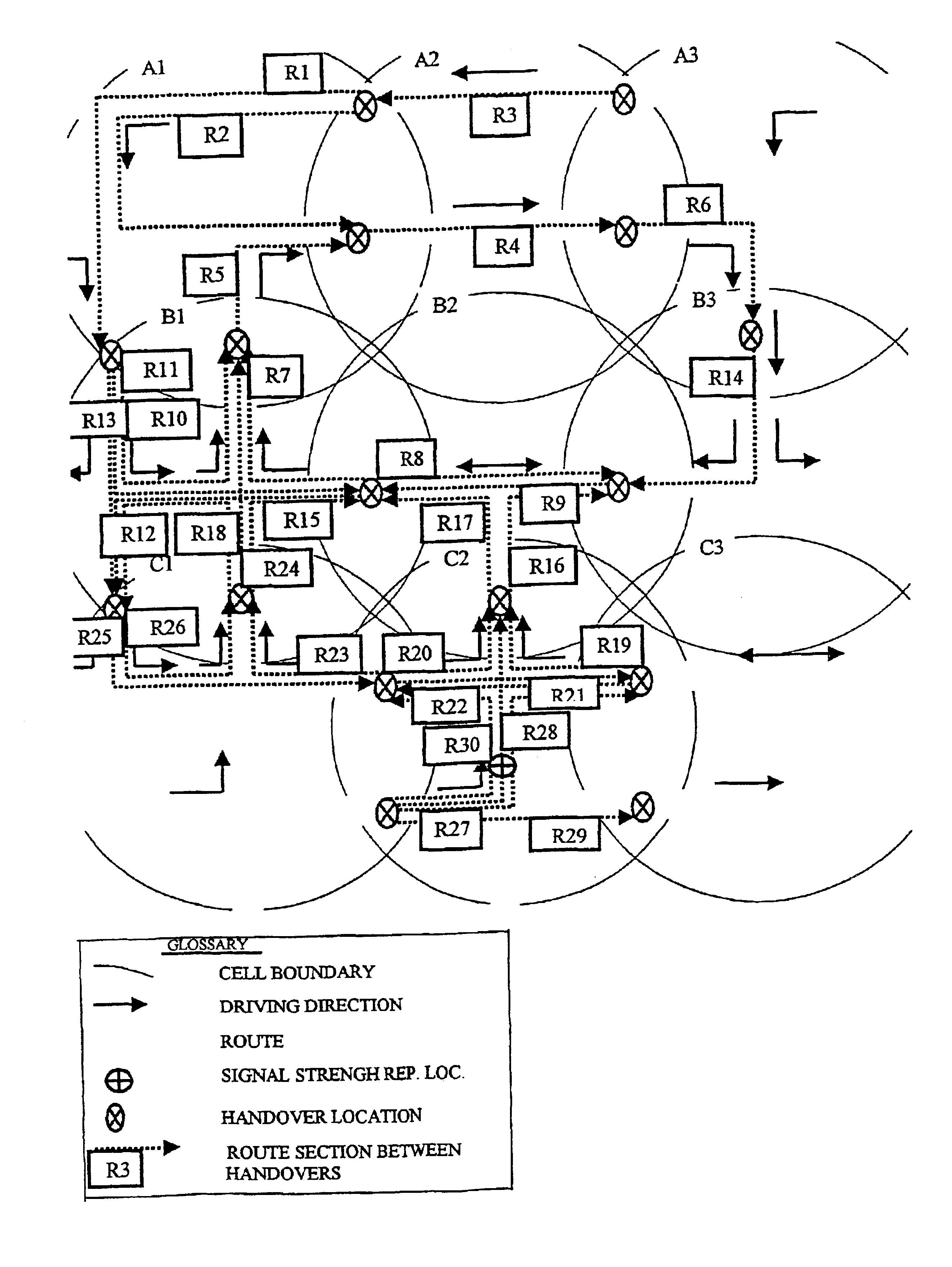
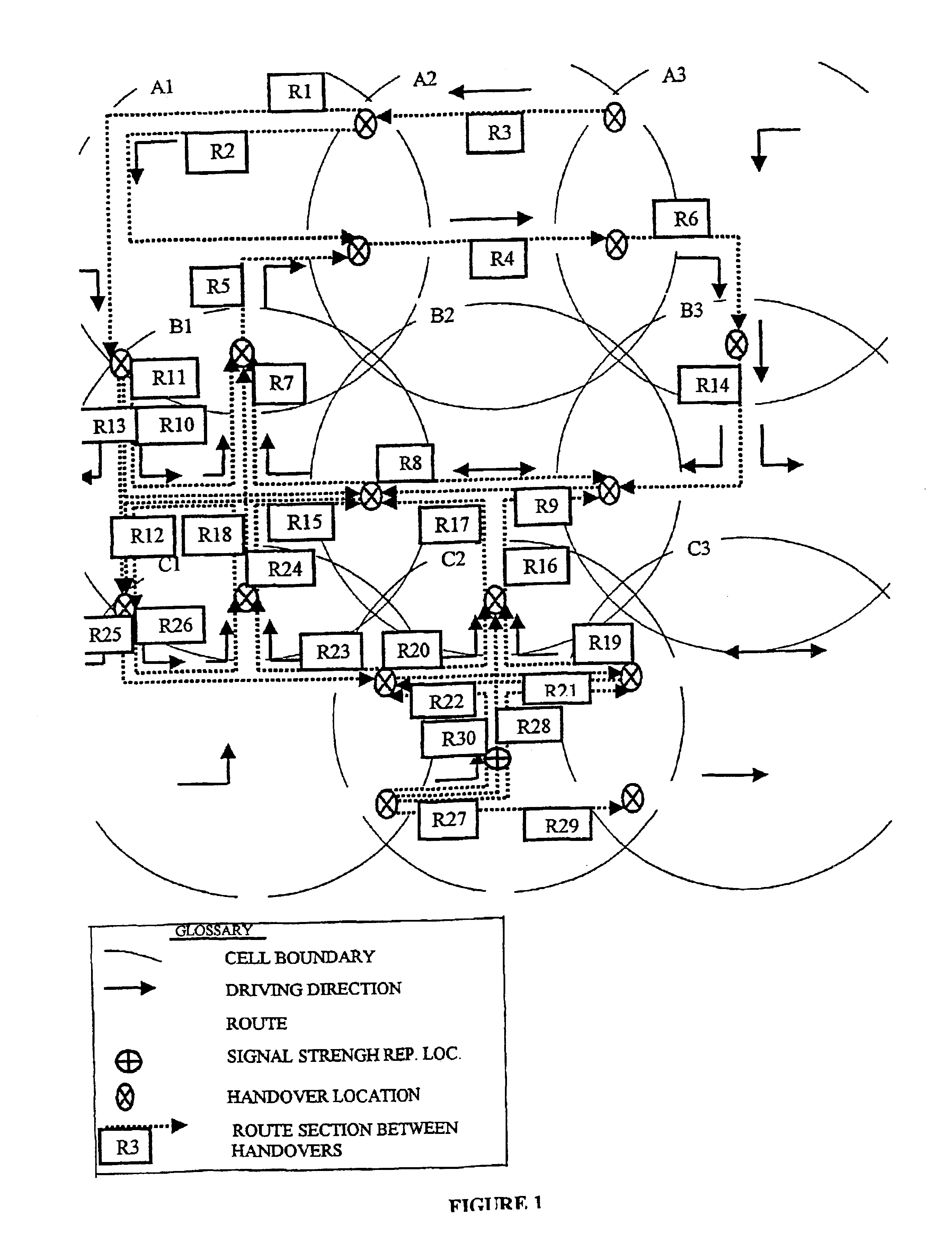
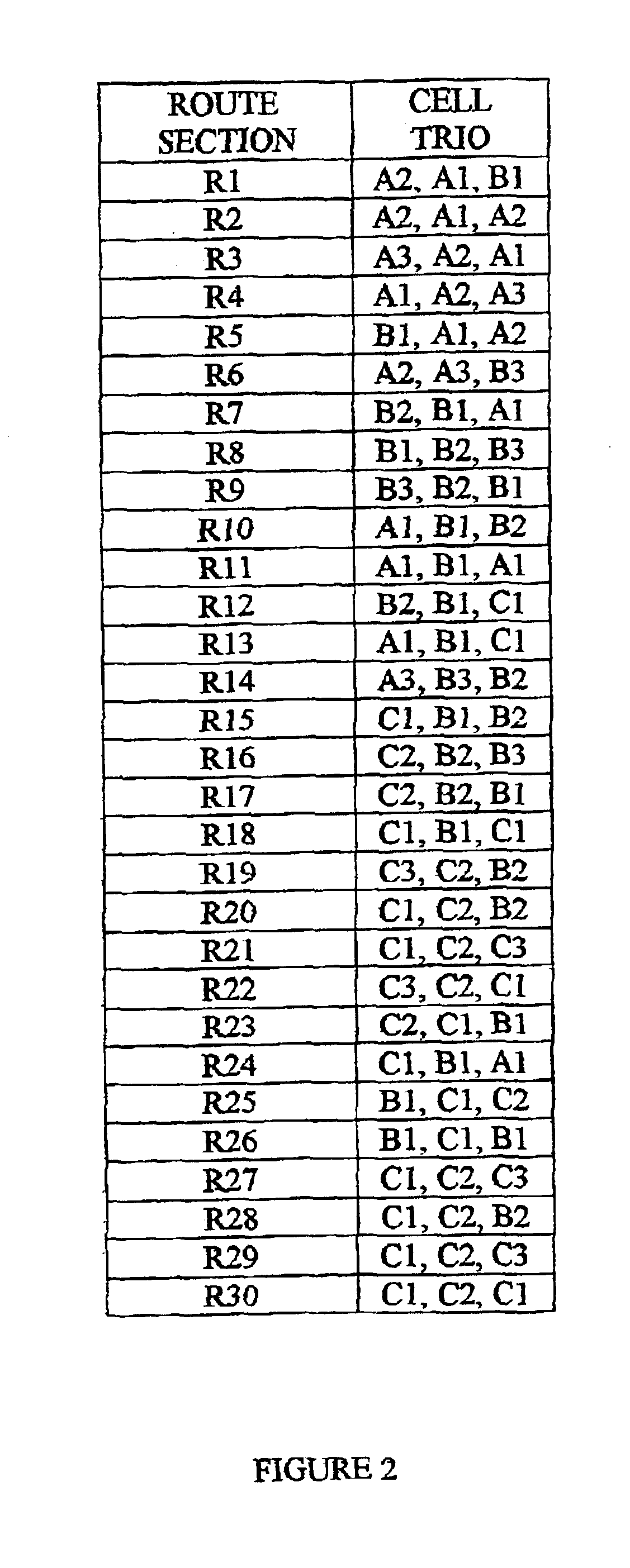
[0033]The current invention derives vehicle location information from the data available on the cellular network. There are 3 main sources from which the data may be collected:[0034]1. Mobile unit reports detailing the signal level from surrounding cells during calls. During a call the mobile unit periodically (every 30 seconds) reports the signal level for the surrounding cells, to be used by the network (the switch) as a basis for it's handover decisions. A single report may not indicate the exact location, since there may be several locations at which the signal level is the same. In addition signal levels may vary due to external factors. However, when several reports are matched against the possible routes a vehicle may take within a certain area, this can be turned into an accurate location accompanied by the exact timing.[0035]This information is available to the base station controller as an integral part of each call, and can either be extracted from the base station contro...


PUM


Abstract

A system and method that continuously extracts traffic load and speed on roads within the coverage area of a cellular network. The data is extracted directly from the higher level of communications in a cellular network without using any external sensors. The cellular data used by the system includes cell handover sequences as the major input. The method consists of a learn phase in which a vehicle with a location device (say GPS system) travels across the covered routes and collects the cellular data and location data in parallel. In the continuous data collection stage the cellular data is processed and correlated to the data collected in the learn phase to yield the route and exact location of the vehicle on it. Each such two locations yield the travel distance and time, and thus the driving speed in this route section. This procedure is performed continuously across the covered area to yield the traffic load and speed.

Description

FIELD[0001]This invention relates generally to traffic load monitoring, and in particular to determining the location and speed of vehicles carrying mobile phones using the cellular phone system.BACKGROUND[0002]Real time traffic loads detection and traffic speed measurement in specific routes is an urgent and important need in the modern urban areas. Statistical data about traffic loads in different time frames is a valuable asset for municipal planning authorities as well as commercial companies (road services, fleet companies etc.)[0003]Until now these needs are fulfilled only partially, not in real time and in a very costly manner: Airplanes in peak hours, Cameras at key locations and (inaccurate) reports of driver's experience are used to generate partial, close to real time traffic data. Counters periodically located across the road in specific locations are used to generate local and partial statistical traffic data.[0004]These inaccurate, costly methods are being used because...

Claims


Application Information

Patent Timeline
IPC IPC(8): G08G1/01H04Q7/34H04W24/00H04W64/00
CPCG08G1/0104H04W24/00H04W64/006
Inventor KAPLAN, JOSEPHAVNI, OFER
Owner CELLINT TRAFFIC SOLUTIONS LTD
Why Eureka
Try Eureka