
Supervised point map matcher

a point map and matcher technology, applied in the direction of navigation instruments, instruments, process and machine control, etc., can solve the problems of satellite geometry, error or inaccurate measurement, and simple location on its own not being useful to a user,

Active Publication Date: 2020-07-02
HERE GLOBAL BV
View PDF0 Cites 9 Cited by
  • Summary
  • Abstract
  • Description
  • Claims
  • Application Information

AI Technical Summary

Benefits of technology

The patent describes a method and device for identifying the current road segment based on positional data and heading data of a device. The method uses a point based map matching algorithm to accurately match positional points and determine the distance and heading errors between the map and the device's positional data. The device includes a global positioning system, a magnetometer, a geographic database, and a map matching processor. The technical effects of the patent include improving accuracy and efficiency of map matching and identifying the current road segment in real-time navigation.

Problems solved by technology

A simple location on its own may not be useful to a user.
For location data such as from GPS, there exists the possibility for errors or inaccurate measurements.
Satellite geometry also becomes an issue when using a GPS receiver in a vehicle, near tall buildings, or in mountainous or canyon areas.
The fewer the satellites, the less accurate the GPS position will be.
Another source of error in GPS is multipath.
The added time increases the potential for error in the overall position determination.
For example, errors may be introduced when signals are reflected of buildings or geographical entities such as large rocks, etc.
As the less direct path will be longer and take extra time, this can add errors into the system if the receiver recognizes the reflected signal.
Propagation delay due to atmospheric effects and internal clock errors may also affect accuracy.
Clock errors may be introduced as a clock inside the receiver may be nowhere near as accurate as the atomic clocks on board the satellite.
GPS satellite orbit errors may also result from deviations from the positions given in ephemeris data.
The result is that while GPS is useful, it is not accurate enough to pin point the exact location of a receiver.
Errors or inaccurate measurements for positional data may lead to incorrect map matches.
Incorrect map matches may result in severe consequences for both the mapping service and an end user.
However, for most applications that require vehicle location, such a positional output is meaningless unless the latitude and longitude can be correlated to a road or feature.
While this method is easy and quick to implement it may be inaccurate when dealing with complicated roadway configurations.
A point based map matcher may have difficultly correctly matching the positional points.
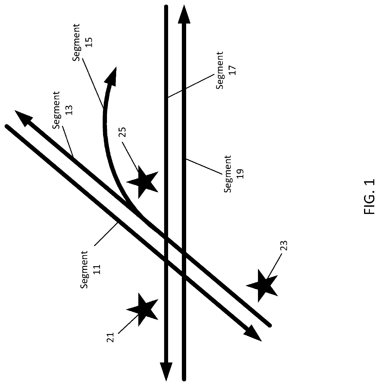
Even using heading, the probe point 25 may be difficult for a point based map matcher.
Using additional information such as prior data points or other more complex algorithms may provide an accurate answer but may be too slow or too computationally intensive.
This is one of the problems with map matching.
There is a tradeoff between accuracy and speed.
Point based map matchers are known to be very fast but include lower accuracy while path based map matchers are slower but include higher accuracy.
The accurate map matched points are used to identify the error patterns of segments that are located in challenging road geometry that makes it hard for a point based map matcher to obtain accurate map matching.
It is often impossible to determine a GPS position inside tunnels, inside buildings or in urban canyons.
GPS receivers cannot provide a maximum deviation and thus, for example, are unable to indicate that the calculated location lies within 3.5 meters of the actual location with 95% probability.
The complexity of the algorithms is both related to the accuracy of the algorithm and the processing time and resources required.
More complex algorithms such as path based map matching algorithms may be more accurate, but require additional time, additional inputs, and additional computing resources.
However, the quickness and efficiency comes with a downside of not being as accurate as, for example, a path based map matcher.
Changing the bandwidth changes the shape of the kernel: for a lower bandwidth, only points very close to the current position are given any weight, which leads to the estimate looking chaotic.
A naïve point based map-matchers may have problems in this type of road geometry as probes on the parallel road (going in same direction) get miss map matched, also probes going on exit ramp, sometimes is map matched to the highway.
KDE is a data smoothing problem where inferences about the entire population are made based on a finite data sample.
Additionally, the illustrations are merely representational and may not be drawn to scale.

Method used


Image

  • Supervised point map matcher
  • Supervised point map matcher
  • Supervised point map matcher

Examples


embodiment 1

[0132]The following embodiments are disclosed. A method for providing a point based map matching algorithm, the method comprising: acquiring a plurality of probe reports for a road segment, the plurality of probe reports comprising heading data and a plurality of positional points generated using global positioning systems; map matching the plurality of positional points using a path based map matching algorithm; map matching the plurality of positional points using a point based map matching algorithm; determining accurately point based map matched positional points and erroneously point based map matched positional points using a comparison between the path based map matched positional points and the point based map matched positional points; identifying a distance error value and a heading error value for each of the accurately point based map matched positional points and the erroneously point based map matched positional points; generating, using kernel density estimation, a p...

embodiment 4

[0135] the method of embodiment 1, wherein the plurality of probe reports are for road segments include the same configuration.

[0136]Embodiment 5: the method of embodiment 1, wherein providing the probability weights comprises: storing the probability weights as an artifact for the road segment in a geographic database.

embodiment 6

[0137] the method of embodiment 1, wherein the heading data is provided by a magnetometer.

[0138]Embodiment 7: the method of embodiment 1, wherein the probability density distributions are gaussian.

[0139]Embodiment 8: the method of embodiment 7, wherein a respective probability weight is calculated using a mean and a variance of the respective probability density distribution.


PUM


Abstract

System and methods are provided for a supervised point map matcher. The supervised point map matcher learns parameters from historical data that provide insight into the optimal probabilistic metrics that inform the bias of probes heading and distance for segments on the roadway. Probability weights for segments are generated. A more accurate path based map matching algorithm is used to identify direction and heading errors in the historical probe data. Values for the probability weights are calculated using kernel density estimation and a gaussian probability density function. The probability weights are used to improve the real time performance of the point map matcher. A confidence value is calculated as a function of the probability weights and provided with the map matched results.

Description

FIELD[0001]The following disclosure relates to navigation devices or services.BACKGROUND[0002]Navigation services use positional data to locate vehicles or devices. A simple location on its own may not be useful to a user. Map matching is the process used to match the location to a digital map where the map matched location may be used in mapping or routing applications. The input to most matching algorithms includes location data acquired using a systems such as a global positioning system referred to commonly as GPS.[0003]For location data such as from GPS, there exists the possibility for errors or inaccurate measurements. An accurate location determination from a GPS receiver requires line of sight with GPS satellites. Satellite geometry also becomes an issue when using a GPS receiver in a vehicle, near tall buildings, or in mountainous or canyon areas. When the GPS signals are blocked from several satellites, the relative position of the remaining satellites determines how accu...

Claims


Application Information

Patent Timeline
IPC IPC(8): G01C21/30G01C21/34G01C21/36
CPCG01C21/3415G01C21/3667G01C21/30G05D1/0274G06F17/18G01C21/3811G01C21/3819
Inventor FOWE, JAMES
Owner HERE GLOBAL BV
Learn More