Unsupervised learning of metric representations from slow features

Active Publication Date: 2019-09-05
HONDA RES INST EUROPE
View PDF7 Cites 8 Cited by
  • Summary
  • Abstract
  • Description
  • Claims
  • Application Information

AI Technical Summary

Benefits of technology

This patent proposes a way to learn how to navigate without needing outside sensors, which saves money and makes the process more robust against synchronization issues. The method can be used in mobile devices like self-localizing lawn mowers, and it improves position accuracy by combining displacement data (odometer data) with a map of the environment created from the learned parameters. The approach uses linear movement patterns along straight line segments as a constraint to make it possible to extract metric positions.

Problems solved by technology

Localization is a key issue for mobile autonomous devices (mobile robots), as many functions such as moving to a target location starting from a current location require the current location in position data.
While the cited approaches are feasible for research purposes, their use is ill suited for a small commercial robots like a lawn mowing robot with only limited computing resources.
The locations need not be connected as in a topological map and interpolation between the locations may not be possible.
In contrast to the SLAM approaches mentioned above, environment representations generated based on slowness learning algorithms, sometimes referred to as temporal stability learning, are not metric and thus have no direct way to include metric odometer data.
However, a multitude of potentially uncalibrated additional sensors providing sensor data can be used to generate environmental representations with a relatively simple setup and low computational effort.
The use of external sensors, however, is costly, cumbersome and often problematic because of synchronization issues between the autonomous device and external sensors.
The method combines odometry with its locally excellent results, which nevertheless degrade with time, and a learned environmental representation, which finds a consistent spatial representation globally, but is inherently non-metric and locally jittered.
The precision of displacement data degrades with time during the movement due to accumulating errors.
Thus, limited memory and computational resources are used economically.

Method used


Image

  • Unsupervised learning of metric representations from slow features
  • Unsupervised learning of metric representations from slow features
  • Unsupervised learning of metric representations from slow features

Examples


Embodiment Construction

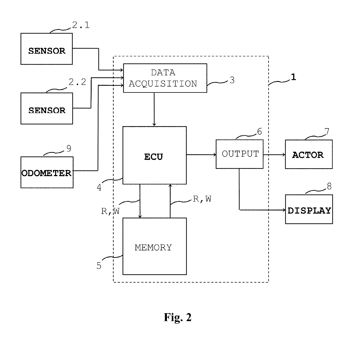
[0069]The term odometry is used for methods using integration the mobile device's displacement measurements, for example from wheel turns or an IMU. The term is used for displacement sensors or odometer systems (sensors) as well as for integrated displacement measurements which provide displacement data.

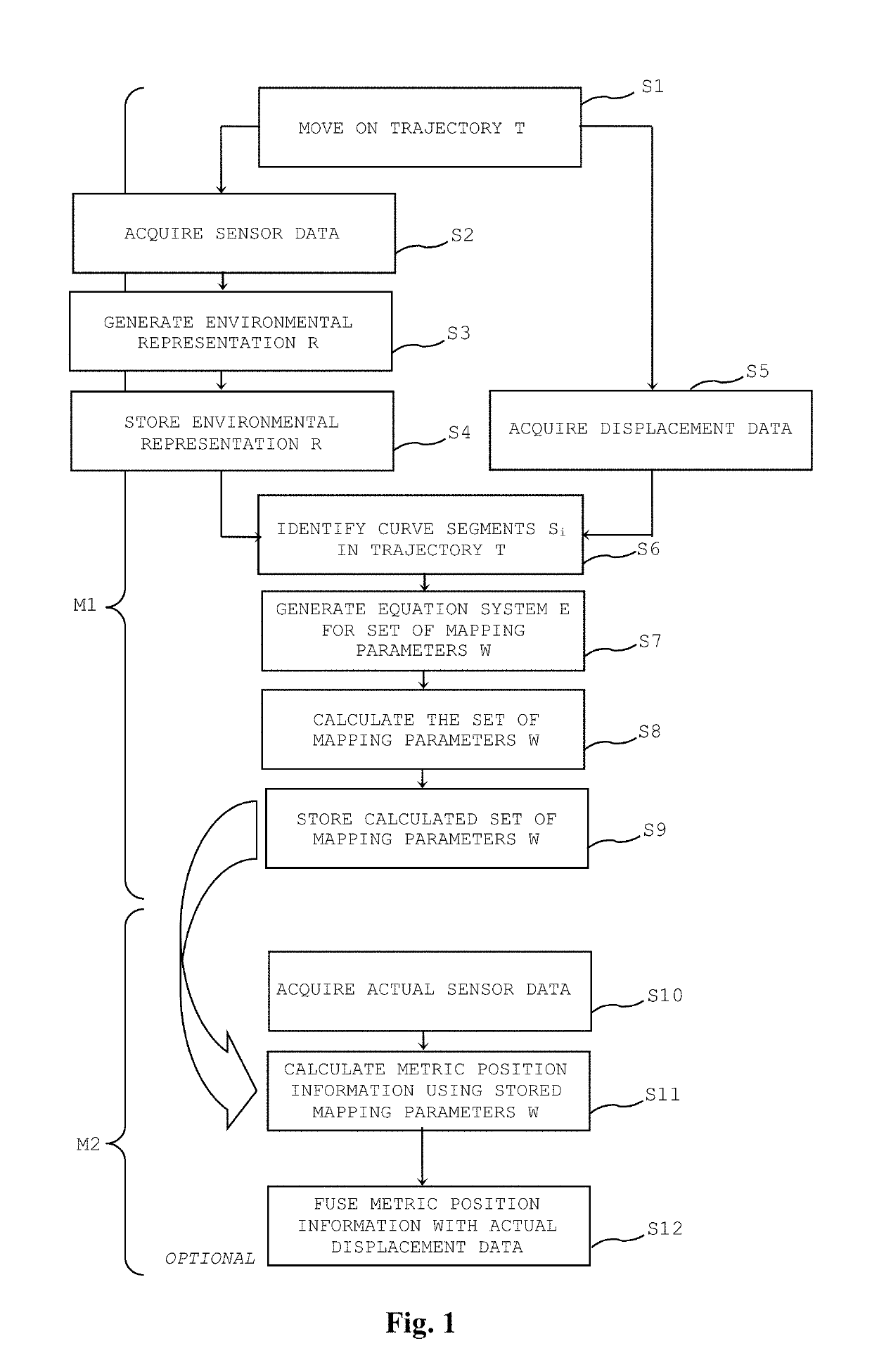
[0070]In FIG. 1 a flowchart of a self-localization method for a mobile device according to an embodiment is shown. For the structural units and modules of the localization system reference to FIG. 2 and reference numbers in FIG. 2 is made.

[0071]Generally a navigation method for a mobile device comprises two distinct phases: In a (first) learning (training) phase M1 environmental representations R are learned. In a (second) application phase M2, a navigation task is performed based on the learned environmental representations R.

[0072]A navigation task can include navigating the mobile device from a starting point to a target point in a working area (working environment).

[0073]The indi...


PUM


Abstract

A method of unsupervised learning of a metric representation and a corresponding system for a mobile device determines a metric position information for a mobile device from an environmental representation. The mobile device comprises at least one sensor for acquiring sensor data and an odometer system configured to acquire displacement data of the mobile device. An environmental representation is generated based on the acquired sensor data by applying an unsupervised learning algorithm. The mobile device moves along a trajectory and the displacement data and the sensor data are acquired while the mobile device is moving along the trajectory. A set of mapping parameters is calculated based on the environmental representation and the displacement data. A metric position estimation is determined based on a further environmental representation and the calculated set of mapping parameters.

Description

BACKGROUNDField[0001]The invention relates to the field of self-localization of mobile systems and in particular for autonomous mobile systems such as robots, using unsupervised learning such as slow feature analysis for generating environmental representations. The invention proposes a method for unsupervised learning of a metric representation and a corresponding system for a mobile device.Description of the Related Art[0002]Localization is a key issue for mobile autonomous devices (mobile robots), as many functions such as moving to a target location starting from a current location require the current location in position data.[0003]Visual Self-Localization is an emerging field of research. A camera sensor on a mobile robot yields rich and versatile sensor data that can be used for localization purposes. Major classes of localization approaches are for example Self Localization and Mapping (SLAM) algorithms and algorithms based on slowness learning such as Slow Feature Analysis ...

Claims


Application Information

Patent Timeline
IPC IPC(8): G06N3/04G06F17/18H04W4/02G06N3/08
CPCG06N3/0472G06F17/18G06N3/088H04W4/026H04W4/027G05D1/0272G05D1/0274G01C21/3407G06V20/56G06N3/047
Inventor FRANZIUS, MATHIASMETKA, BENJAMINBAUER-WERSING, UTE
Owner HONDA RES INST EUROPE
Why Eureka
Try Eureka